Enable Location

We need your location to show you interesting places around you

Discover nearby places

Find interesting locations and hidden gems around you

Precise directions

Get accurate directions and distances to places

Your location is never shared with other users. It's only used when you tap the location button.

Swan's Landing Archeological Site

Log in to your account

Start exploring — it's free

Trusted by 63,764 travelers worldwide

Continue with Google
Continue with Apple
or

We will send you a code to connect

By continuing, you accept our Terms and Conditions and our Privacy Policy

Check your inbox

We've sent a pincode in your inbox. Please enter the code below.

Discussion Reviews 1 Photos
1.5k Popularity

Swan's Landing Archeological Site, Archaeological site in Harrison County, Indiana, United States.

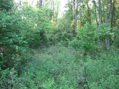
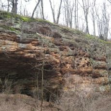
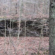
Swan's Landing is an archaeological site along the Ohio River in Harrison County where excavations have uncovered ancient artifacts and layers from prehistoric times. The location spans across several hectares and reveals multiple levels of human activity from the distant past.

The site dates from the Early Archaic period thousands of years ago and shows that people lived in this region during ancient times. The finds document an important phase of early human settlement in North America.

The excavations revealed numerous Kirk cluster projectile points, scrapers, hammerstones, and stone tools made from local Wyandotte chert materials.

The site is located near a river and characterized by floodplain terrain that visitors should keep in mind. Finding the exact location requires local knowledge and you should check accessibility conditions beforehand.

The region contains an exceptionally large amount of local flint, a material that ancient inhabitants used to make tools. This natural deposit was a reason why people regularly visited and worked at this location.

The community of curious travelers

AroundUs brings together thousands of curated places, local tips, and hidden gems, enriched daily by 60,000 contributors worldwide.

Start exploring
Location
GPS coordinates
38.13181,-86.26889
Latest update
December 14, 2025 15:01
Around this place
Marengo Cave
United States of America

Marengo Cave

27.8 km
Confederate Monument in Louisville
United States of America

Confederate Monument in Louisville

16.6 km
Wyandotte Caves
United States of America

Wyandotte Caves

11 km
Corydon Historic District
United States of America

Corydon Historic District

15.5 km
Fort Duffield
United States of America

Fort Duffield

32.6 km
Doe Run Inn
United States of America

Doe Run Inn

23.1 km
O'Bannon Woods State Park
United States of America

O'Bannon Woods State Park

11 km
Harrison Spring
United States of America

Harrison Spring

13.1 km
Matthew E. Welsh Bridge
United States of America

Matthew E. Welsh Bridge

14.2 km
Rockhouse Cliffs Rockshelters
United States of America

Rockhouse Cliffs Rockshelters

28.2 km
Harrison–Crawford State Forest
United States of America

Harrison–Crawford State Forest

8.1 km
Kintner-Withers House
United States of America

Kintner-Withers House

25.4 km
Potts Creek Rockshelter
United States of America

Potts Creek Rockshelter

27.8 km
Corydon Battle Site
United States of America

Corydon Battle Site

14.4 km
Kintner-McGrain House
United States of America

Kintner-McGrain House

15.8 km
Jacob Rickenbaugh House
United States of America

Jacob Rickenbaugh House

30.7 km
Gabriel Farnsley House
United States of America

Gabriel Farnsley House

32.3 km
Meade County Jail
United States of America

Meade County Jail

16.7 km
Irvington Historic District
United States of America

Irvington Historic District

27.8 km
Old Perry County Courthouse
United States of America

Old Perry County Courthouse

32.2 km
Brandenburg Methodist Episcopal Church
United States of America

Brandenburg Methodist Episcopal Church

17.1 km
Georgetown Historic District
United States of America

Georgetown Historic District

31.4 km
William Proctor House
United States of America

William Proctor House

26.6 km
Edward Yeakel House
United States of America

Edward Yeakel House

16.9 km
Brandenburg Commercial District
United States of America

Brandenburg Commercial District

16.8 km
Jones-Willis House
United States of America

Jones-Willis House

16.9 km
Corydon Capitol State Historic Site
United States of America

Corydon Capitol State Historic Site

15.5 km
Doe Run Creek Historic District
United States of America

Doe Run Creek Historic District

23.6 km
Show the full map
Reviews
Share your experience

No review yet

Discussions
Start a discussion...

No discussion yet

« Swan's Landing Archeological Site - Archaeological site in Harrison County, Indiana, United States » is provided by Around Us (aroundus.com). Images and texts are derived from Wikimedia project under a Creative Commons license. You are allowed to copy, distribute, and modify copies of this page, under the conditions set by the license, as long as this note is clearly visible.

Discover hidden gems everywhere you go!

From secret cafés to breathtaking viewpoints, skip the crowded tourist spots and find places that match your style. Our app makes it easy with voice search, smart filtering, route optimization, and insider tips from travelers worldwide. Download now for the complete mobile experience.

Around Us App Screenshot

A unique approach to discovering new places

Le Figaro

All the places worth exploring

France Info

A tailor-made excursion in just a few clicks

20 Minutes

Around Us
Travel Guide & Maps
Download

Send to your phone

QR Code
1

Open the camera app on your mobile.

2

Point at the QR code with your camera. A notification will appear.

3

Tap the notification to open the link.