Enable Location

We need your location to show you interesting places around you

Discover nearby places

Find interesting locations and hidden gems around you

Precise directions

Get accurate directions and distances to places

Your location is never shared with other users. It's only used when you tap the location button.

Troy Public High School

Log in to your account

Start exploring — it's free

Trusted by 63,307 travelers worldwide

Continue with Google
Continue with Apple
or

We will send you a code to connect

By continuing, you accept our Terms and Conditions and our Privacy Policy

Check your inbox

We've sent a pincode in your inbox. Please enter the code below.

Discussion Reviews 1 Photos
1.6k Popularity

Troy Public High School, high school in Pennsylvania, United States

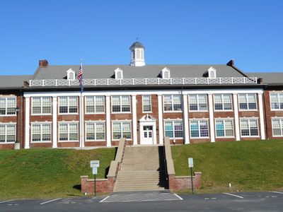
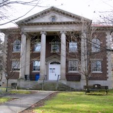
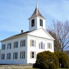
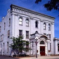
Troy Public High School is a school building in Pennsylvania located on High Street on a large property. The structure was built between 1923 and 1924, with extensions added in the 1930s and additional facilities like a gymnasium, library, and auditorium constructed in 1954.

The building was reconstructed after a fire in 1922 and reopened in 1924 with modern facilities. The location has deeper roots, with a schoolhouse built in 1823 and an academy established in 1840 before the current structure was created.

The school is named after Troy and serves as a community landmark that reflects local values around education. Its presence in the town has made it a gathering place for residents across generations who recognize it as central to the area's sense of identity.

The building is located on High Street and easy to spot, with clear markings indicating its historic status. Keep in mind this is an active school, so it is best to arrange access ahead of time or observe the exterior from the public area.

The building was designed by architects Lawrie and Lappley and features an E-shaped structure with nine vertical sections. A distinctive octagonal cupola crowns the roof, giving the building a recognizable silhouette from various angles.

The community of curious travelers

AroundUs brings together thousands of curated places, local tips, and hidden gems, enriched daily by 60,000 contributors worldwide.

Start exploring
Location
GPS coordinates
41.78917,-76.78556
Latest update
February 9, 2026 08:19
Around this place
Newtown Battlefield State Park
United States of America

Newtown Battlefield State Park

28.8 km
Mt. Pisgah State Park
United States of America

Mt. Pisgah State Park

10 km
Old Loggers Path
United States of America

Old Loggers Path

31.2 km
Elmira Coca-Cola Bottling Company Works
United States of America

Elmira Coca-Cola Bottling Company Works

33.5 km
Park Church
United States of America

Park Church

33.5 km
Chemung County Historical Society
United States of America

Chemung County Historical Society

33.4 km
F. M. Howell and Company
United States of America

F. M. Howell and Company

33.1 km
Chemung Canal Bank Building
United States of America

Chemung Canal Bank Building

33.3 km
Bradford County Courthouse
United States of America

Bradford County Courthouse

28.9 km
Methodist Episcopal Church of Burlington
United States of America

Methodist Episcopal Church of Burlington

12.9 km
Protection of the Flag Monument
United States of America

Protection of the Flag Monument

28.7 km
Waverly Village Hall
United States of America

Waverly Village Hall

31.2 km
John Brand Jr. House
United States of America

John Brand Jr. House

32.9 km
Alexander Eustace House
United States of America

Alexander Eustace House

32.9 km
Sunbury Historic District
United States of America

Sunbury Historic District

8.1 km
Spalding Memorial Library-Tioga Point Museum
United States of America

Spalding Memorial Library-Tioga Point Museum

28.7 km
John Brand Sr. House
United States of America

John Brand Sr. House

32.9 km
Athens Historic District
United States of America

Athens Historic District

28.6 km
Towanda Historic District
United States of America

Towanda Historic District

28.2 km
Universalist Meeting House of Sheshequin
United States of America

Universalist Meeting House of Sheshequin

25.6 km
United States Post Office (Waverly, New York)
United States of America

United States Post Office (Waverly, New York)

31.2 km
Christ Episcopal Church
United States of America

Christ Episcopal Church

25.6 km
Bridge in Athens Township
United States of America

Bridge in Athens Township

29.3 km
Van Dyne Civic Building
United States of America

Van Dyne Civic Building

311 m
Dr. Hovey Everett House
United States of America

Dr. Hovey Everett House

30.3 km
Chemung District School No. 10
United States of America

Chemung District School No. 10

27.3 km
Chemung Valley History Museum
United States of America

Chemung Valley History Museum

33.3 km
Knapp's Covered Bridge
United States of America

Knapp's Covered Bridge

19.3 km
Show the full map
Reviews
Share your experience

No review yet

Discussions
Start a discussion...

No discussion yet

« Troy Public High School - high school in Pennsylvania, United States » is provided by Around Us (aroundus.com). Images and texts are derived from Wikimedia project under a Creative Commons license. You are allowed to copy, distribute, and modify copies of this page, under the conditions set by the license, as long as this note is clearly visible.

Discover hidden gems everywhere you go!

From secret cafés to breathtaking viewpoints, skip the crowded tourist spots and find places that match your style. Our app makes it easy with voice search, smart filtering, route optimization, and insider tips from travelers worldwide. Download now for the complete mobile experience.

Around Us App Screenshot

A unique approach to discovering new places

Le Figaro

All the places worth exploring

France Info

A tailor-made excursion in just a few clicks

20 Minutes

Around Us
Travel Guide & Maps
Download

Send to your phone

QR Code
1

Open the camera app on your mobile.

2

Point at the QR code with your camera. A notification will appear.

3

Tap the notification to open the link.