Enable Location

We need your location to show you interesting places around you

Discover nearby places

Find interesting locations and hidden gems around you

Precise directions

Get accurate directions and distances to places

Your location is never shared with other users. It's only used when you tap the location button.

Tygart River Reservoir Dam

Log in to your account

Start exploring — it's free

Trusted by 62,520 travelers worldwide

Continue with Google
Continue with Apple
or

We will send you a code to connect

By continuing, you accept our Terms and Conditions and our Privacy Policy

Check your inbox

We've sent a pincode in your inbox. Please enter the code below.

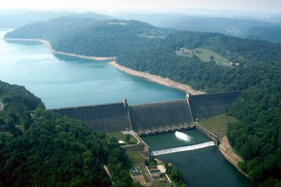
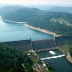
Tygart River Reservoir Dam, Gravity dam in Taylor County, United States.

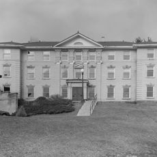
Tygart River Reservoir Dam is a concrete structure featuring Art Deco design elements visible in its facade. The dam system stores water for power generation and flood control while creating a large reservoir behind it.

The dam was built between 1934 and 1938 as a New Deal project during the economic crisis. It fundamentally changed the region, requiring the relocation of communities while providing employment during difficult economic times.

The structure displays Art Deco design elements that reflect the architectural style of its era. Today it stands as a testament to engineering achievement and draws visitors interested in how industrial design shaped American infrastructure.

The site is accessible during most seasons and offers viewpoints overlooking the valley and reservoir. Visitors should wear comfortable shoes, as there are steep paths and stairs to reach different areas.

It was designed by Paul Philippe Cret, a French-American architect known for his modernist approach. His influence shows throughout the structure, where functional engineering meets artistic design.

The community of curious travelers

AroundUs brings together thousands of curated places, local tips, and hidden gems, enriched daily by 60,000 contributors worldwide.

Start exploring
Location
Architects
Paul Philippe Cret
Elevation above the sea
334 m
GPS coordinates
39.31140,-80.03280
Latest update
December 12, 2025 08:01
Around this place
Philippi Covered Bridge
United States of America

Philippi Covered Bridge

17.6 km
Tygart Lake State Park
United States of America

Tygart Lake State Park

1.2 km
Valley Falls State Park
United States of America

Valley Falls State Park

10.1 km
Pleasant Creek Wildlife Management Area
United States of America

Pleasant Creek Wildlife Management Area

6 km
High Gate
United States of America

High Gate

20.9 km
Grafton National Cemetery
United States of America

Grafton National Cemetery

2.8 km
Anna Jarvis House
United States of America

Anna Jarvis House

2.2 km
United States of America

West Virginia National Cemetery

4 km
Barbour County Courthouse
United States of America

Barbour County Courthouse

17.7 km
Adaland
United States of America

Adaland

12.7 km
Dunbar School
United States of America

Dunbar School

21.8 km
Robert H. Mollohan-Jefferson Street Bridge
United States of America

Robert H. Mollohan-Jefferson Street Bridge

21.2 km
Whitescarver Hall
United States of America

Whitescarver Hall

16.9 km
Governor Joseph Johnson House
United States of America

Governor Joseph Johnson House

19.7 km
Fairmont Normal School Administration Building
United States of America

Fairmont Normal School Administration Building

22 km
Philippi Historic District
United States of America

Philippi Historic District

18 km
Peck-Crim-Chesser House
United States of America

Peck-Crim-Chesser House

17.6 km
Jacobs-Hutchinson Block
United States of America

Jacobs-Hutchinson Block

21.5 km
Fairmont Downtown Historic District
United States of America

Fairmont Downtown Historic District

21.3 km
Thomas C. Miller Public School
United States of America

Thomas C. Miller Public School

21.9 km
Fairmont Railroad Bridge
United States of America

Fairmont Railroad Bridge

19.9 km
J.N.B. Crim House
United States of America

J.N.B. Crim House

20.1 km
Fleming-Watson Historic District
United States of America

Fleming-Watson Historic District

21.2 km
Thomas W. Fleming House
United States of America

Thomas W. Fleming House

21.3 km
Shaw House
United States of America

Shaw House

20.7 km
Clelland House
United States of America

Clelland House

13.8 km
Grafton Downtown Commercial Historic District
United States of America

Grafton Downtown Commercial Historic District

3.4 km
Marion County Courthouse
United States of America

Marion County Courthouse

21.5 km
Show the full map
« Tygart River Reservoir Dam - Gravity dam in Taylor County, United States » is provided by Around Us (aroundus.com). Images and texts are derived from Wikimedia project under a Creative Commons license. You are allowed to copy, distribute, and modify copies of this page, under the conditions set by the license, as long as this note is clearly visible.

Discover hidden gems everywhere you go!

From secret cafés to breathtaking viewpoints, skip the crowded tourist spots and find places that match your style. Our app makes it easy with voice search, smart filtering, route optimization, and insider tips from travelers worldwide. Download now for the complete mobile experience.

Around Us App Screenshot

A unique approach to discovering new places

Le Figaro

All the places worth exploring

France Info

A tailor-made excursion in just a few clicks

20 Minutes

Around Us
Travel Guide & Maps
Download

Send to your phone

QR Code
1

Open the camera app on your mobile.

2

Point at the QR code with your camera. A notification will appear.

3

Tap the notification to open the link.