Enable Location

We need your location to show you interesting places around you

Discover nearby places

Find interesting locations and hidden gems around you

Precise directions

Get accurate directions and distances to places

Your location is never shared with other users. It's only used when you tap the location button.

Philippi Covered Bridge

Log in to your account

Start exploring — it's free

Trusted by 62,530 travelers worldwide

Continue with Google
Continue with Apple
or

We will send you a code to connect

By continuing, you accept our Terms and Conditions and our Privacy Policy

Check your inbox

We've sent a pincode in your inbox. Please enter the code below.

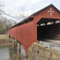
Philippi Covered Bridge, Historic covered bridge in Barbour County, United States.

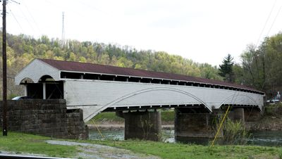
Philippi Covered Bridge is an 87-meter wooden structure spanning the Tygart Valley River with a double-barrel design supported by three sandstone piers. The bridge crosses water with sloped approaches on both banks and functions as part of the active road network.

Construction finished in 1852 under builder Lemuel Chenoweth, and the crossing later gained military importance during conflict in the 1860s. The bridge continued in use after wartime damage and received major restoration work in the late 20th century.

The bridge holds status on the National Register since 1972, showing early American construction methods. Visitors see here a working example of 19th-century engineering that still serves its original purpose.

Vehicles use this working bridge daily on US Route 250, so expect occasional traffic when crossing. The structure accommodates normal car traffic, and visiting during quieter times offers a better experience for photographs.

This is the only covered bridge in the entire United States remaining as part of the federal highway system. This distinction makes it a remarkable example of historical infrastructure maintained within the modern road network.

The community of curious travelers

AroundUs brings together thousands of curated places, local tips, and hidden gems, enriched daily by 60,000 contributors worldwide.

Start exploring
Location
Inception
1852
GPS coordinates
39.15310,-80.04360
Latest update
December 9, 2025 18:45
Around this place
Tygart Lake State Park
United States of America

Tygart Lake State Park

16.9 km
Audra State Park
United States of America

Audra State Park

12.7 km
Valley Falls State Park
United States of America

Valley Falls State Park

27 km
Tygart River Reservoir Dam
United States of America

Tygart River Reservoir Dam

17.6 km
Pleasant Creek Wildlife Management Area
United States of America

Pleasant Creek Wildlife Management Area

12.1 km
Grafton National Cemetery
United States of America

Grafton National Cemetery

20.4 km
Carrollton Covered Bridge
United States of America

Carrollton Covered Bridge

7.9 km
Anna Jarvis House
United States of America

Anna Jarvis House

15.6 km
United States of America

West Virginia National Cemetery

20.1 km
Barbour County Courthouse
United States of America

Barbour County Courthouse

386 m
William Post Mansion
United States of America

William Post Mansion

23.6 km
Adaland
United States of America

Adaland

5.8 km
Templemoor
United States of America

Templemoor

17.1 km
Whitescarver Hall
United States of America

Whitescarver Hall

811 m
Governor Joseph Johnson House
United States of America

Governor Joseph Johnson House

23.7 km
Philippi Historic District
United States of America

Philippi Historic District

533 m
Downtown Buckhannon Historic District
United States of America

Downtown Buckhannon Historic District

23.9 km
Agnes Howard Hall
United States of America

Agnes Howard Hall

23.8 km
Peck-Crim-Chesser House
United States of America

Peck-Crim-Chesser House

380 m
Bernard E. Wilmoth House
United States of America

Bernard E. Wilmoth House

16.5 km
Daniel Bassel House
United States of America

Daniel Bassel House

27 km
J.N.B. Crim House
United States of America

J.N.B. Crim House

6.6 km
Quality Hill Historic District
United States of America

Quality Hill Historic District

28.5 km
Trinity Memorial Methodist Episcopal Church
United States of America

Trinity Memorial Methodist Episcopal Church

28.8 km
Clelland House
United States of America

Clelland House

28.4 km
Grafton Downtown Commercial Historic District
United States of America

Grafton Downtown Commercial Historic District

20.9 km
Southern Methodist Church Building
United States of America

Southern Methodist Church Building

24.2 km
Buckhannon Central Residential Historical District
United States of America

Buckhannon Central Residential Historical District

23.9 km
Show the full map
« Philippi Covered Bridge - Historic covered bridge in Barbour County, United States » is provided by Around Us (aroundus.com). Images and texts are derived from Wikimedia project under a Creative Commons license. You are allowed to copy, distribute, and modify copies of this page, under the conditions set by the license, as long as this note is clearly visible.

Discover hidden gems everywhere you go!

From secret cafés to breathtaking viewpoints, skip the crowded tourist spots and find places that match your style. Our app makes it easy with voice search, smart filtering, route optimization, and insider tips from travelers worldwide. Download now for the complete mobile experience.

Around Us App Screenshot

A unique approach to discovering new places

Le Figaro

All the places worth exploring

France Info

A tailor-made excursion in just a few clicks

20 Minutes

Around Us
Travel Guide & Maps
Download

Send to your phone

QR Code
1

Open the camera app on your mobile.

2

Point at the QR code with your camera. A notification will appear.

3

Tap the notification to open the link.