Enable Location

We need your location to show you interesting places around you

Discover nearby places

Find interesting locations and hidden gems around you

Precise directions

Get accurate directions and distances to places

Your location is never shared with other users. It's only used when you tap the location button.

Carrollton Covered Bridge

Log in to your account

Start exploring — it's free

Trusted by 62,519 travelers worldwide

Continue with Google
Continue with Apple
or

We will send you a code to connect

By continuing, you accept our Terms and Conditions and our Privacy Policy

Check your inbox

We've sent a pincode in your inbox. Please enter the code below.

Carrollton Covered Bridge, Covered bridge in Barbour County, US

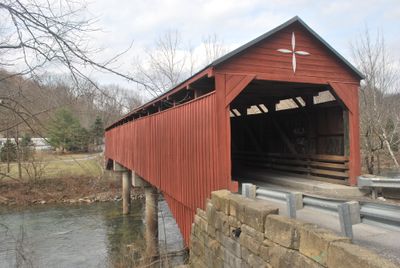
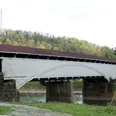
Carrollton Covered Bridge is a wooden span crossing the Buckhannon River in Barbour County, West Virginia. The structure features a protective roof and wooden siding, sitting on concrete supports with a single-lane concrete deck accessible to vehicles.

Built in 1856 by local builders Emmet and Daniel O'Brien, this structure became part of a turnpike system connecting regional roads in the area. It represents a key crossing point from the period when such wooden bridges were essential to local transportation networks.

The bridge represents mid-19th century engineering methods with its combination of Burr trusses and multiple Kingpost trusses spanning the waterway.

The bridge sits along West Virginia Route 36 and is easy to reach from this highway. The concrete deck accommodates vehicle traffic, and a dedicated walkway serves pedestrians crossing on foot.

A fire caused significant damage to the structure, but restoration teams worked to bring it back using a combination of salvaged timber and freshly milled wood. This recovery effort showed the determination to preserve such landmarks for future visitors.

The community of curious travelers

AroundUs brings together thousands of curated places, local tips, and hidden gems, enriched daily by 60,000 contributors worldwide.

Start exploring
Location
Inception
1856
GPS coordinates
39.09010,-80.08670
Latest update
December 14, 2025 11:05
Around this place
Monongahela National Forest
United States of America

Monongahela National Forest

27.3 km
Philippi Covered Bridge
United States of America

Philippi Covered Bridge

7.9 km
Tygart Lake State Park
United States of America

Tygart Lake State Park

24.5 km
Audra State Park
United States of America

Audra State Park

5.8 km
Tygart River Reservoir Dam
United States of America

Tygart River Reservoir Dam

25.1 km
Pleasant Creek Wildlife Management Area
United States of America

Pleasant Creek Wildlife Management Area

19.2 km
Graceland
United States of America

Graceland

27.1 km
Anna Jarvis House
United States of America

Anna Jarvis House

22.9 km
United States of America

West Virginia National Cemetery

27 km
Barbour County Courthouse
United States of America

Barbour County Courthouse

8.1 km
Halliehurst mansion
United States of America

Halliehurst mansion

27.3 km
William Post Mansion
United States of America

William Post Mansion

16 km
Adaland
United States of America

Adaland

12.4 km
Davis and Elkins Historic District
United States of America

Davis and Elkins Historic District

27.3 km
Templemoor
United States of America

Templemoor

14.6 km
Whitescarver Hall
United States of America

Whitescarver Hall

8.7 km
Governor Joseph Johnson House
United States of America

Governor Joseph Johnson House

26.3 km
Philippi Historic District
United States of America

Philippi Historic District

7.8 km
Downtown Buckhannon Historic District
United States of America

Downtown Buckhannon Historic District

16.4 km
Agnes Howard Hall
United States of America

Agnes Howard Hall

16.1 km
Peck-Crim-Chesser House
United States of America

Peck-Crim-Chesser House

8.1 km
Bernard E. Wilmoth House
United States of America

Bernard E. Wilmoth House

14.5 km
Daniel Bassel House
United States of America

Daniel Bassel House

24.7 km
J.N.B. Crim House
United States of America

J.N.B. Crim House

6.6 km
Southern Methodist Church Building
United States of America

Southern Methodist Church Building

16.7 km
Pinecrest
United States of America

Pinecrest

26.8 km
Buckhannon Central Residential Historical District
United States of America

Buckhannon Central Residential Historical District

16.3 km
Kanawha Theater
United States of America

Kanawha Theater

16.5 km
Show the full map
« Carrollton Covered Bridge - Covered bridge in Barbour County, US » is provided by Around Us (aroundus.com). Images and texts are derived from Wikimedia project under a Creative Commons license. You are allowed to copy, distribute, and modify copies of this page, under the conditions set by the license, as long as this note is clearly visible.

Discover hidden gems everywhere you go!

From secret cafés to breathtaking viewpoints, skip the crowded tourist spots and find places that match your style. Our app makes it easy with voice search, smart filtering, route optimization, and insider tips from travelers worldwide. Download now for the complete mobile experience.

Around Us App Screenshot

A unique approach to discovering new places

Le Figaro

All the places worth exploring

France Info

A tailor-made excursion in just a few clicks

20 Minutes

Around Us
Travel Guide & Maps
Download

Send to your phone

QR Code
1

Open the camera app on your mobile.

2

Point at the QR code with your camera. A notification will appear.

3

Tap the notification to open the link.