Enable Location

We need your location to show you interesting places around you

Discover nearby places

Find interesting locations and hidden gems around you

Precise directions

Get accurate directions and distances to places

Your location is never shared with other users. It's only used when you tap the location button.

Anna Jarvis House

Log in to your account

Start exploring — it's free

Trusted by 62,520 travelers worldwide

Continue with Google
Continue with Apple
or

We will send you a code to connect

By continuing, you accept our Terms and Conditions and our Privacy Policy

Check your inbox

We've sent a pincode in your inbox. Please enter the code below.

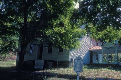
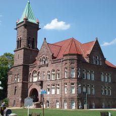
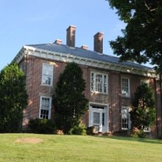
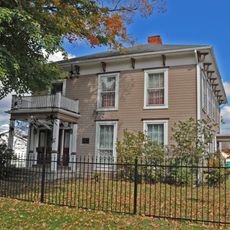
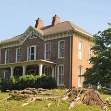
Anna Jarvis House, Historic residence in Webster, United States.

The Anna Jarvis House is a two-story residential building with a gabled roof and balanced front facade, showing how people lived during the mid-1800s in West Virginia. The structure now functions as a museum with displays about the family and their connection to the founding of Mother's Day.

Built in 1854, the house served in 1861 as the first field headquarters for General George B. McClellan during his military campaign in western Virginia. This military use made the building an important location during the early stages of the Civil War in the region.

The house is connected to Anna Jarvis, who grew up here and later established Mother's Day as a national observance. Visitors can see how the family lived in this space and understand its role in her life.

The museum is located at the intersection of U.S. Routes 119 and 250, making it straightforward to find. Visitors should come prepared for a historic house interior and plan accordingly for the size and layout of a residential building.

During the Civil War, General McClellan's staff used the house for important decisions, showing its significance beyond the family story. Today visitors can experience both aspects of this history, making the house a rare intersection of family and military history.

The community of curious travelers

AroundUs brings together thousands of curated places, local tips, and hidden gems, enriched daily by 60,000 contributors worldwide.

Start exploring
Location
Inception
1854
GPS coordinates
39.29360,-80.04420
Latest update
December 14, 2025 11:24
Around this place
Philippi Covered Bridge
United States of America

Philippi Covered Bridge

15.6 km
Tygart Lake State Park
United States of America

Tygart Lake State Park

2.2 km
Valley Falls State Park
United States of America

Valley Falls State Park

11.6 km
Tygart River Reservoir Dam
United States of America

Tygart River Reservoir Dam

2.2 km
Pleasant Creek Wildlife Management Area
United States of America

Pleasant Creek Wildlife Management Area

3.8 km
High Gate
United States of America

High Gate

22.2 km
Grafton National Cemetery
United States of America

Grafton National Cemetery

4.9 km
Carrollton Covered Bridge
United States of America

Carrollton Covered Bridge

22.9 km
United States of America

West Virginia National Cemetery

4.9 km
Barbour County Courthouse
United States of America

Barbour County Courthouse

15.7 km
Adaland
United States of America

Adaland

10.5 km
Dunbar School
United States of America

Dunbar School

23.2 km
Robert H. Mollohan-Jefferson Street Bridge
United States of America

Robert H. Mollohan-Jefferson Street Bridge

22.6 km
Whitescarver Hall
United States of America

Whitescarver Hall

14.9 km
Governor Joseph Johnson House
United States of America

Governor Joseph Johnson House

18.5 km
Philippi Historic District
United States of America

Philippi Historic District

16 km
Peck-Crim-Chesser House
United States of America

Peck-Crim-Chesser House

15.6 km
Jacobs-Hutchinson Block
United States of America

Jacobs-Hutchinson Block

22.9 km
Fairmont Downtown Historic District
United States of America

Fairmont Downtown Historic District

22.7 km
Thomas C. Miller Public School
United States of America

Thomas C. Miller Public School

23.3 km
Fairmont Railroad Bridge
United States of America

Fairmont Railroad Bridge

21.2 km
Fleming-Watson Historic District
United States of America

Fleming-Watson Historic District

22.6 km
J.N.B. Crim House
United States of America

J.N.B. Crim House

17.9 km
Thomas W. Fleming House
United States of America

Thomas W. Fleming House

22.7 km
Shaw House
United States of America

Shaw House

22.2 km
Clelland House
United States of America

Clelland House

14.6 km
Grafton Downtown Commercial Historic District
United States of America

Grafton Downtown Commercial Historic District

5.6 km
Marion County Courthouse
United States of America

Marion County Courthouse

23 km
Show the full map
« Anna Jarvis House - Historic residence in Webster, United States » is provided by Around Us (aroundus.com). Images and texts are derived from Wikimedia project under a Creative Commons license. You are allowed to copy, distribute, and modify copies of this page, under the conditions set by the license, as long as this note is clearly visible.

Discover hidden gems everywhere you go!

From secret cafés to breathtaking viewpoints, skip the crowded tourist spots and find places that match your style. Our app makes it easy with voice search, smart filtering, route optimization, and insider tips from travelers worldwide. Download now for the complete mobile experience.

Around Us App Screenshot

A unique approach to discovering new places

Le Figaro

All the places worth exploring

France Info

A tailor-made excursion in just a few clicks

20 Minutes

Around Us
Travel Guide & Maps
Download

Send to your phone

QR Code
1

Open the camera app on your mobile.

2

Point at the QR code with your camera. A notification will appear.

3

Tap the notification to open the link.