Monongahela National Forest

Log in to your account

AroundUs is a community-driven map of interesting places, built by curious explorers like you. It grows with every review, story, and photo you share.
Connect to save your favorite spots, contribute locations, and create personalized routes.
By continuing, you accept our Terms and Conditions and our Privacy Policy
Add to collection
Map
Suggest a change
Share

Monongahela National Forest, National Forest in West Virginia, United States.

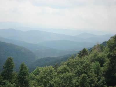
Monongahela National Forest is a vast woodland spanning West Virginia's varied terrain with rivers and mountains. The landscape transitions from river valleys to ridges reaching roughly 4,000 feet (1,200 meters) in elevation.

The forest received protected status in 1915 after heavy logging had stripped much of the region's resources. This protection marked the beginning of a long process to restore the forest and allow ecosystems to recover.

The forest takes its name from the Monongahela River that runs through the region and has shaped local identity for centuries. The land holds traces of communities who built their lives around forestry and land stewardship.

The forest offers over 1,200 kilometers of trails at various difficulty levels along with designated areas for camping, fishing, and wildlife watching. Plan your visit based on the season, as weather and trail conditions vary significantly throughout the year.

Cranberry Glades contains rare wetlands with plants typically found in much colder northern regions. A specialized boardwalk allows visitors to explore this botanical area while protecting the fragile ecosystem beneath their feet.

Location: West Virginia

Elevation above the sea: 1,191 m

Operator: United States Forest Service

Website: https://fs.usda.gov/mnf

GPS coordinates: 38.92920,-79.84780

Latest update: December 6, 2025 22:08

Photos
Around this place
Audra State Park
United States of America

Audra State Park

22.5 km
Otter Creek Wilderness
United States of America

Otter Creek Wilderness

20.4 km
Bickle Knob
United States of America

Bickle Knob

10.1 km
Shavers Mountain
United States of America

Shavers Mountain

22.6 km
Graceland
United States of America

Graceland

230 m
Fernow Experimental Forest
United States of America

Fernow Experimental Forest

19.6 km
Halliehurst mansion
United States of America

Halliehurst mansion

186 m
Tygart Valley Homesteads Historic District
United States of America

Tygart Valley Homesteads Historic District

17.7 km
Randolph County Courthouse and Jail
United States of America

Randolph County Courthouse and Jail

821 m
Tucker County Courthouse and Jail
United States of America

Tucker County Courthouse and Jail

23.6 km
Davis and Elkins Historic District
United States of America

Davis and Elkins Historic District

189 m
Albert and Liberal Arts Halls
United States of America

Albert and Liberal Arts Halls

191 m
Gov. H. Guy Kump House
United States of America

Gov. H. Guy Kump House

1.3 km
Scott Hill
United States of America

Scott Hill

2.1 km
Warfield-Dye Residence
United States of America

Warfield-Dye Residence

262 m
First Ward School
United States of America

First Ward School

1.2 km
Bernard E. Wilmoth House
United States of America

Bernard E. Wilmoth House

13.6 km
Riverside School
United States of America

Riverside School

534 m
Downtown Elkins Historic District
United States of America

Downtown Elkins Historic District

548 m
Wees Historic District
United States of America

Wees Historic District

496 m
Beverly Historic District
United States of America

Beverly Historic District

10.1 km
Tucker County Bank Building
United States of America

Tucker County Bank Building

23.9 km
Pinecrest
United States of America

Pinecrest

520 m
Taylor-Condry House
United States of America

Taylor-Condry House

2.4 km
Butcher Hill Historic District
United States of America

Butcher Hill Historic District

9.7 km
Elkins Milling Company
United States of America

Elkins Milling Company

747 m
Blackman-Bosworth Store
United States of America

Blackman-Bosworth Store

10.1 km
Dr. John C. Irons House
United States of America

Dr. John C. Irons House

639 m
Show the full map
Reviews

Visited this place? Tap the stars to rate it and share your experience / photos with the community! Try now! You can cancel it anytime.

« Monongahela National Forest - National Forest in West Virginia, United States » is provided by Around Us (aroundus.com). Images and texts are derived from Wikimedia project under a Creative Commons license. You are allowed to copy, distribute, and modify copies of this page, under the conditions set by the license, as long as this note is clearly visible.

Discover hidden gems everywhere you go!

From secret cafés to breathtaking viewpoints, skip the crowded tourist spots and find places that match your style. Our app makes it easy with voice search, smart filtering, route optimization, and insider tips from travelers worldwide. Download now for the complete mobile experience.

Around Us App Screenshot

A unique approach to discovering new places

Le Figaro

All the places worth exploring

France Info

A tailor-made excursion in just a few clicks

20 Minutes