Enable Location

We need your location to show you interesting places around you

Discover nearby places

Find interesting locations and hidden gems around you

Precise directions

Get accurate directions and distances to places

Your location is never shared with other users. It's only used when you tap the location button.

Bickle Knob

Log in to your account

Start exploring — it's free

Trusted by 62,507 travelers worldwide

Continue with Google
Continue with Apple
or

We will send you a code to connect

By continuing, you accept our Terms and Conditions and our Privacy Policy

Check your inbox

We've sent a pincode in your inbox. Please enter the code below.

Bickle Knob

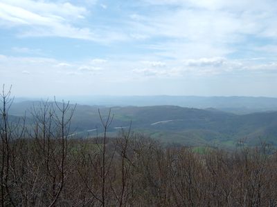
Bickle Knob, Mountain summit in Randolph County, United States

Bickle Knob is a mountain summit with an observation tower in the Appalachian region of West Virginia that overlooks the Monongahela National Forest and the mountain ranges surrounding it. The tower allows visitors to view the landscape from an elevated position and see distant areas of forest and peaks.

The wooden observation tower was built in 1933 by the Civilian Conservation Corps as part of infrastructure development in West Virginia. This construction helped make the mountainous terrain accessible to visitors and those interested in the outdoors.

The summit draws outdoor explorers who come to experience the mountain views and surrounding forests of West Virginia. Visitors gather here to take in the landscape and share in the activity of hiking to elevated vantage points.

The hike to the tower is short and starts from the parking area, with morning hours providing the best views and clearer visibility. Wear comfortable hiking shoes and be aware that conditions change depending on the season and weather.

On clear days, visitors standing at the tower can spot the Mount Storm smokestacks in Tucker County and the Shinnston smokestacks in Harrison County in the distance. These distant industrial structures create a visible connection to activities beyond the forest and show how the landscape connects across borders.

The community of curious travelers

AroundUs brings together thousands of curated places, local tips, and hidden gems, enriched daily by 60,000 contributors worldwide.

Start exploring
Location
Elevation above the sea
834 m
GPS coordinates
38.93417,-79.73139
Latest update
December 12, 2025 09:05
Around this place
Monongahela National Forest
United States of America

Monongahela National Forest

10.1 km
Otter Creek Wilderness
United States of America

Otter Creek Wilderness

12.9 km
Shavers Mountain
United States of America

Shavers Mountain

13.2 km
Graceland
United States of America

Graceland

10.2 km
Fernow Experimental Forest
United States of America

Fernow Experimental Forest

13.9 km
Laurel Fork North Wilderness
United States of America

Laurel Fork North Wilderness

20.3 km
Halliehurst mansion
United States of America

Halliehurst mansion

10 km
Randolph County Courthouse and Jail
United States of America

Randolph County Courthouse and Jail

9.8 km
Tucker County Courthouse and Jail
United States of America

Tucker County Courthouse and Jail

18.6 km
Davis and Elkins Historic District
United States of America

Davis and Elkins Historic District

10 km
Albert and Liberal Arts Halls
United States of America

Albert and Liberal Arts Halls

9.9 km
Gov. H. Guy Kump House
United States of America

Gov. H. Guy Kump House

9.8 km
Scott Hill
United States of America

Scott Hill

11.5 km
Warfield-Dye Residence
United States of America

Warfield-Dye Residence

9.9 km
First Ward School
United States of America

First Ward School

10.5 km
Day-Vandevander Mill
United States of America

Day-Vandevander Mill

18.1 km
Bernard E. Wilmoth House
United States of America

Bernard E. Wilmoth House

20.8 km
Downtown Elkins Historic District
United States of America

Downtown Elkins Historic District

10.3 km
Wees Historic District
United States of America

Wees Historic District

9.7 km
Beverly Historic District
United States of America

Beverly Historic District

16.2 km
Tucker County Bank Building
United States of America

Tucker County Bank Building

19.1 km
Pinecrest
United States of America

Pinecrest

10.5 km
Taylor-Condry House
United States of America

Taylor-Condry House

10.8 km
Butcher Hill Historic District
United States of America

Butcher Hill Historic District

15.6 km
Elkins Milling Company
United States of America

Elkins Milling Company

10.5 km
Blackman-Bosworth Store
United States of America

Blackman-Bosworth Store

16.2 km
Dr. John C. Irons House
United States of America

Dr. John C. Irons House

10.3 km
Beverly Heritage Center
United States of America

Beverly Heritage Center

16.3 km
Show the full map
« Bickle Knob - Mountain summit in Randolph County, United States » is provided by Around Us (aroundus.com). Images and texts are derived from Wikimedia project under a Creative Commons license. You are allowed to copy, distribute, and modify copies of this page, under the conditions set by the license, as long as this note is clearly visible.

Discover hidden gems everywhere you go!

From secret cafés to breathtaking viewpoints, skip the crowded tourist spots and find places that match your style. Our app makes it easy with voice search, smart filtering, route optimization, and insider tips from travelers worldwide. Download now for the complete mobile experience.

Around Us App Screenshot

A unique approach to discovering new places

Le Figaro

All the places worth exploring

France Info

A tailor-made excursion in just a few clicks

20 Minutes

Around Us
Travel Guide & Maps
Download

Send to your phone

QR Code
1

Open the camera app on your mobile.

2

Point at the QR code with your camera. A notification will appear.

3

Tap the notification to open the link.