Chest opened
+${chestReward.xp} XP
Explorer
NOUVEAU ×${chestReward.collectible.quantity}
tapez pour fermer
Chest locked

Open chests in the app

Around Us is built for your phone — chests unlock when you walk, explore and capture nearby places.

Enable Location

We need your location to show you interesting places around you

Discover nearby places

Find interesting locations and hidden gems around you

Precise directions

Get accurate directions and distances to places

Your location is never shared with other users. It's only used when you tap the location button.

Upstate South Carolina

Log in to your account

Start exploring — it's free

Trusted by 72,992 travelers worldwide

Continue with Google
Continue with Apple
or

We will send you a code to connect

By continuing, you accept our Terms and Conditions and our Privacy Policy

Check your inbox

We've sent a pincode in your inbox. Please enter the code below.

Discussion Reviews 3 Photos
68.8k Popularity

Upstate South Carolina, Geographic region in northwestern South Carolina, United States.

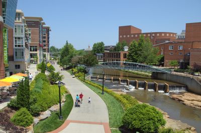
Upstate South Carolina is a region in northwestern South Carolina that stretches from the Blue Ridge Mountains down through rolling piedmont hills with several large reservoirs and forest areas. The area covers ten counties connected by a network of highways and concentrates much of its activity along the Interstate 85 corridor.

The area developed as a textile manufacturing center during the early 20th century with cotton mills and weaving plants in small towns across the region. Starting in the 1990s, the economy shifted when international automotive manufacturers began establishing production facilities in several counties.

The area maintains strong educational foundations through institutions like Clemson University, Furman University, and numerous technical colleges serving diverse communities.

The international airport between Greenville and Spartanburg offers direct flights to major American cities and some European destinations. Drivers will find plenty of rest stops and gas stations along the main highways that cross through the area.

Several European tire makers and automotive suppliers built plants here to support the large assembly sites in the region. The concentration of foreign investment has led some towns to post bilingual signs.

The community of curious travelers

AroundUs brings together thousands of curated places, local tips, and hidden gems, enriched daily by 60,000 contributors worldwide.

Start exploring
Location
GPS coordinates
34.71670,-82.18330
Latest update
December 13, 2025 17:57
Around this place
Frankie's Fun Park
United States of America

Frankie's Fun Park

15.5 km
Roper Mountain Science Center
United States of America

Roper Mountain Science Center

17.8 km
Lanneau-Norwood House
United States of America

Lanneau-Norwood House

23.1 km
Splash Pad
United States of America

Splash Pad

18.6 km
Fountain Inn High School
United States of America

Fountain Inn High School

3 km
Conestee Nature Preserve
United States of America

Conestee Nature Preserve

17.3 km
First Baptist Simpsonville
United States of America

First Baptist Simpsonville

6.8 km
Mountain Shoals Plantation
United States of America

Mountain Shoals Plantation

21.3 km
Pelham Mills Site
United States of America

Pelham Mills Site

16.1 km
Gray Court-Owings School
United States of America

Gray Court-Owings School

12.1 km
Tullyton
United States of America

Tullyton

13 km
Arthur Barnwell House
United States of America

Arthur Barnwell House

15.9 km
Hurricane Tavern
United States of America

Hurricane Tavern

10.9 km
First Presbyterian Church of Woodruff
United States of America

First Presbyterian Church of Woodruff

13.3 km
Cureton-Huff House
United States of America

Cureton-Huff House

14.2 km
Burdette Building
United States of America

Burdette Building

7 km
James M. Davis House
United States of America

James M. Davis House

16.6 km
Woodruff City Hall
United States of America

Woodruff City Hall

13.8 km
William Bates House
United States of America

William Bates House

15.4 km
C. Granville Wyche House
United States of America

C. Granville Wyche House

21.3 km
Fountain Inn Principal's House and Teacherage
United States of America

Fountain Inn Principal's House and Teacherage

2.4 km
Discovery Island Waterpark
United States of America

Discovery Island Waterpark

11.3 km
Robert Quillen Office and Library
United States of America

Robert Quillen Office and Library

2.9 km
T.Q. Donaldson House
United States of America

T.Q. Donaldson House

23.2 km
Cannon Building
United States of America

Cannon Building

3 km
Reidville Academy Faculty House
United States of America

Reidville Academy Faculty House

17.2 km
Nicholls-Crook House
United States of America

Nicholls-Crook House

16.4 km
F. W. Welborn House
United States of America

F. W. Welborn House

2.8 km
Show the full map
Reviews
Share your experience

No review yet

Discussions
Start a discussion...

No discussion yet

« Upstate South Carolina - Geographic region in northwestern South Carolina, United States » is provided by Around Us (aroundus.com). Images and texts are derived from Wikimedia project under a Creative Commons license. You are allowed to copy, distribute, and modify copies of this page, under the conditions set by the license, as long as this note is clearly visible.

Discover hidden gems everywhere you go!

From secret cafés to breathtaking viewpoints, skip the crowded tourist spots and find places that match your style. Our app makes it easy with voice search, smart filtering, route optimization, and insider tips from travelers worldwide. Download now for the complete mobile experience.

Around Us App Screenshot

A unique approach to discovering new places

Le Figaro

All the places worth exploring

France Info

A tailor-made excursion in just a few clicks

20 Minutes

Around Us
Travel Guide & Maps
Download

Send to your phone

QR Code
1

Open the camera app on your mobile.

2

Point at the QR code with your camera. A notification will appear.

3

Tap the notification to open the link.