Chest opened
+${chestReward.xp} XP
Explorer
NOUVEAU ×${chestReward.collectible.quantity}
tapez pour fermer
Chest locked

Open chests in the app

Around Us is built for your phone — chests unlock when you walk, explore and capture nearby places.

Enable Location

We need your location to show you interesting places around you

Discover nearby places

Find interesting locations and hidden gems around you

Precise directions

Get accurate directions and distances to places

Your location is never shared with other users. It's only used when you tap the location button.

Log in to your account

Start exploring — it's free

Trusted by 72,895 travelers worldwide

Continue with Google
Continue with Apple
or

We will send you a code to connect

By continuing, you accept our Terms and Conditions and our Privacy Policy

Check your inbox

We've sent a pincode in your inbox. Please enter the code below.

Discussion Reviews Photo
24.6k Popularity

WJR, Radio station in Detroit, Michigan, US

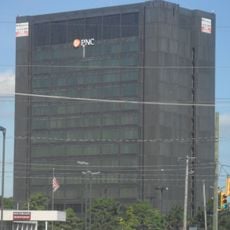
WJR is a radio station in Detroit that broadcasts from the Fisher Building in the New Center district. The station operates on 760 AM with 50,000 watts of power, which allows it to reach a wide area.

The Detroit Free Press received the original broadcast license in 1922 and laid the foundation for what would become WJR. A few years later, the station merged with Jewett Radio & Phonograph and acquired the business and identity it carries today.

The station became known as 'The Goodwill Station' and earned trust as a place where listeners found news they could rely on and voices discussing community issues. For generations, the call letters WJR represented connection and information for people across the region.

You can listen to the programming through a traditional AM radio receiver or through digital platforms offering news and talk content. The signal is strongest and most reliable in the region when using a modern receiver device.

As a clear-channel station, WJR can broadcast its signal across multiple states during nighttime hours, while daytime reach remains more limited. This peculiarity makes the station a window to distant regions of the country after dark.

The community of curious travelers

AroundUs brings together thousands of curated places, local tips, and hidden gems, enriched daily by 60,000 contributors worldwide.

Start exploring
Location
Inception
1922
GPS coordinates
42.16810,-83.21500
Latest update
December 20, 2025 12:21
Around this place
Grosse Ile
United States of America

Grosse Ile

6.2 km
Fort Malden
Canada

Fort Malden

10.8 km
Detroit River International Wildlife Refuge
United States of America

Detroit River International Wildlife Refuge

8.6 km
Grosse Ile Toll Bridge
United States of America

Grosse Ile Toll Bridge

4.6 km
Lake Erie Metropark
United States of America

Lake Erie Metropark

10.9 km
Fort Amherstburg
Canada

Fort Amherstburg

10.8 km
Wayne County Bridge
United States of America

Wayne County Bridge

5.6 km
United States of America

Sugar Island

10.3 km
East River Road Historic District
United States of America

East River Road Historic District

7.7 km
Grassy Island
United States of America

Grassy Island

9 km
George P. MacNichol House
United States of America

George P. MacNichol House

7 km
St. James Episcopal Church
United States of America

St. James Episcopal Church

7.7 km
Ford-Bacon House
United States of America

Ford-Bacon House

7 km
Marx House
United States of America

Marx House

7 km
Mellus Newspapers Building
United States of America

Mellus Newspapers Building

9.9 km
Park House Museum
Canada

Park House Museum

11 km
John and Emma Lacey Eberts House
United States of America

John and Emma Lacey Eberts House

6.9 km
Calf Island
United States of America

Calf Island

7.8 km
Wyandotte Odd Fellows Temple
United States of America

Wyandotte Odd Fellows Temple

6.8 km
Gibraltar Road–Waterway Canal Bridge
United States of America

Gibraltar Road–Waterway Canal Bridge

8.4 km
United States of America

Fox Island

9.2 km
Grassy Island Light
United States of America

Grassy Island Light

9.2 km
Parke Lane Road–Thorofare Canal Bridge
United States of America

Parke Lane Road–Thorofare Canal Bridge

5.9 km
East River Road–North Hickory Canal Bridge
United States of America

East River Road–North Hickory Canal Bridge

9.6 km
South Pointe Drive–Frenchman's Creek Bridge
United States of America

South Pointe Drive–Frenchman's Creek Bridge

8.1 km
Ferry Street–Thorofare Canal Bridge
United States of America

Ferry Street–Thorofare Canal Bridge

5.9 km
R.P. McMurphy's
United States of America

R.P. McMurphy's

6.7 km
Southgate Tower
United States of America

Southgate Tower

3 km
Show the full map
Reviews
Share your experience

No review yet

Discussions
Start a discussion...

No discussion yet

« WJR - Radio station in Detroit, Michigan, US » is provided by Around Us (aroundus.com). Images and texts are derived from Wikimedia project under a Creative Commons license. You are allowed to copy, distribute, and modify copies of this page, under the conditions set by the license, as long as this note is clearly visible.

Discover hidden gems everywhere you go!

From secret cafés to breathtaking viewpoints, skip the crowded tourist spots and find places that match your style. Our app makes it easy with voice search, smart filtering, route optimization, and insider tips from travelers worldwide. Download now for the complete mobile experience.

Around Us App Screenshot

A unique approach to discovering new places

Le Figaro

All the places worth exploring

France Info

A tailor-made excursion in just a few clicks

20 Minutes

Around Us
Travel Guide & Maps
Download

Send to your phone

QR Code
1

Open the camera app on your mobile.

2

Point at the QR code with your camera. A notification will appear.

3

Tap the notification to open the link.