Enable Location

We need your location to show you interesting places around you

Discover nearby places

Find interesting locations and hidden gems around you

Precise directions

Get accurate directions and distances to places

Your location is never shared with other users. It's only used when you tap the location button.

Walnut Street Bridge

Log in to your account

Start exploring — it's free

Trusted by 62,282 travelers worldwide

Continue with Google
Continue with Apple
or

We will send you a code to connect

By continuing, you accept our Terms and Conditions and our Privacy Policy

Check your inbox

We've sent a pincode in your inbox. Please enter the code below.

Walnut Street Bridge

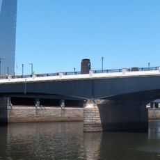
Walnut Street Bridge, Historic truss bridge in Harrisburg, United States.

The Walnut Street Bridge is an iron truss bridge spanning the Susquehanna River, linking downtown Harrisburg with City Island on the opposite bank. The structure comprises fifteen separate spans made of wrought iron that work together to support the crossing.

This bridge was built in 1890 by the Phoenix Bridge Company and showcases advances in standardized iron truss construction during the industrial era. After a major flood in 1972, it was converted from vehicle traffic to serve only pedestrians and cyclists.

The structure carries the nickname 'The People's Bridge' among locals and serves as a central gathering spot for walks and connections between neighborhoods. It brings together residents from both sides of the river through daily foot traffic and community events.

The bridge offers an easy walk with views of the river and connects both sides of the city without vehicular traffic. Access is open and free, allowing visitors to cross on foot or by bicycle at any time.

The eastern section features illuminated outlines that create geometric patterns across the night sky above the river. This lighting transforms the structure into a visual landmark after dark.

The community of curious travelers

AroundUs brings together thousands of curated places, local tips, and hidden gems, enriched daily by 60,000 contributors worldwide.

Start exploring
Location
GPS coordinates
39.95150,-75.18150
Latest update
December 14, 2025 13:05
Around this place
Mütter Museum
United States of America

Mütter Museum

467 m
Cira Centre
United States of America

Cira Centre

640 m
Cira Centre South
United States of America

Cira Centre South

614 m
Pennsylvania Railroad World War II Memorial
United States of America

Pennsylvania Railroad World War II Memorial

463 m
College of Physicians of Philadelphia
United States of America

College of Physicians of Philadelphia

460 m
PECO Building
United States of America

PECO Building

411 m
United States Post Office-Main Branch
United States of America

United States Post Office-Main Branch

495 m
Market Street Bridge
United States of America

Market Street Bridge

339 m
First Presbyterian Church
United States of America

First Presbyterian Church

524 m
Murano
United States of America

Murano

603 m
Centennial National Bank
United States of America

Centennial National Bank

625 m
United States of America

Philly Improv Theater

589 m
John F. Kennedy Boulevard Bridge
United States of America

John F. Kennedy Boulevard Bridge

453 m
Thomas Hockley House
United States of America

Thomas Hockley House

512 m
Chestnut Street Bridge
United States of America

Chestnut Street Bridge

176 m
John C. Bell House
United States of America

John C. Bell House

359 m
Cira Green
United States of America

Cira Green

200 m
Edward Drinker Cope House
United States of America

Edward Drinker Cope House

647 m
Anthony J. Drexel
United States of America

Anthony J. Drexel

544 m
Church of the New Jerusalem
United States of America

Church of the New Jerusalem

473 m
Hockley Row
United States of America

Hockley Row

479 m
Larkin–Belber Building
United States of America

Larkin–Belber Building

635 m
Schuylkill River Park Community Garden
United States of America

Schuylkill River Park Community Garden

236 m
Bishop Mackay-Smith House
United States of America

Bishop Mackay-Smith House

407 m
Harris Building
United States of America

Harris Building

248 m
Ramcat Historic District
United States of America

Ramcat Historic District

323 m
Neill-Mauran House
United States of America

Neill-Mauran House

504 m
Walnut-Chancellor Historic District
United States of America

Walnut-Chancellor Historic District

495 m
Show the full map
« Walnut Street Bridge - Historic truss bridge in Harrisburg, United States » is provided by Around Us (aroundus.com). Images and texts are derived from Wikimedia project under a Creative Commons license. You are allowed to copy, distribute, and modify copies of this page, under the conditions set by the license, as long as this note is clearly visible.

Discover hidden gems everywhere you go!

From secret cafés to breathtaking viewpoints, skip the crowded tourist spots and find places that match your style. Our app makes it easy with voice search, smart filtering, route optimization, and insider tips from travelers worldwide. Download now for the complete mobile experience.

Around Us App Screenshot

A unique approach to discovering new places

Le Figaro

All the places worth exploring

France Info

A tailor-made excursion in just a few clicks

20 Minutes

Around Us
Travel Guide & Maps
Download

Send to your phone

QR Code
1

Open the camera app on your mobile.

2

Point at the QR code with your camera. A notification will appear.

3

Tap the notification to open the link.