Enable Location

We need your location to show you interesting places around you

Discover nearby places

Find interesting locations and hidden gems around you

Precise directions

Get accurate directions and distances to places

Your location is never shared with other users. It's only used when you tap the location button.

Wheat Row

Log in to your account

Start exploring — it's free

Trusted by 63,073 travelers worldwide

Continue with Google
Continue with Apple
or

We will send you a code to connect

By continuing, you accept our Terms and Conditions and our Privacy Policy

Check your inbox

We've sent a pincode in your inbox. Please enter the code below.

Discussion Reviews 1 Photos
2k Popularity

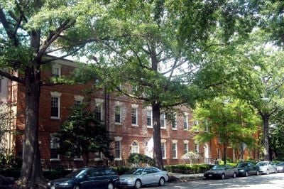
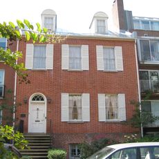
Wheat Row, Late Georgian townhouses in Southwest Waterfront, United States.

Wheat Row comprises four attached brick townhouses on 4th Street SW that display Late Georgian design with distinctive Flemish bond masonry patterns in their walls. The structures are now integrated into a residential cooperative complex while retaining their original red brick facades.

James Clark constructed these townhouses between 1794 and 1795, making them the earliest rowhouse examples in Washington, D.C. They represent the beginning of residential development in the Southwest Waterfront area during the city's formative years.

The row takes its name from John Wheat, a gardener who lived in one of the houses around 1819 and left his mark on the neighborhood's identity. The name persists today as a reminder of the people who shaped this waterfront community long ago.

The townhouses are visible from 4th Street SW and accessible for external viewing as part of the Harbour Square residential complex in the neighborhood. Walking along the street provides clear views of the historic red brick facades from the public sidewalk.

Despite multiple renovation phases since the 1700s, the foundations and original brick walls have retained their structural integrity and early architectural elements. This longevity is rare for buildings from this era in the city.

The community of curious travelers

AroundUs brings together thousands of curated places, local tips, and hidden gems, enriched daily by 60,000 contributors worldwide.

Start exploring
Location
GPS coordinates
38.87389,-77.01806
Latest update
December 14, 2025 09:41
Around this place
Museum of the Bible
United States of America

Museum of the Bible

1.2 km
USS Sequoia
United States of America

USS Sequoia

422 m
International Spy Museum
United States of America

International Spy Museum

1.3 km
The Anthem
United States of America

The Anthem

976 m
Titanic Memorial
United States of America

Titanic Memorial

245 m
Ford House Office Building
United States of America

Ford House Office Building

1.2 km
Buzzard Point
United States of America

Buzzard Point

941 m
The Wharf
United States of America

The Wharf

841 m
East Potomac Park
United States of America

East Potomac Park

813 m
Robert C. Weaver Federal Building
United States of America

Robert C. Weaver Federal Building

1.2 km
Frederick Douglass Memorial Bridge
United States of America

Frederick Douglass Memorial Bridge

1.2 km
Roosevelt Hall
United States of America

Roosevelt Hall

1.2 km
Constitution Center
United States of America

Constitution Center

1.1 km
Thomas Law House
United States of America

Thomas Law House

293 m
Ohio Drive SW
United States of America

Ohio Drive SW

1.2 km
United States of America

Waterfront Tower

449 m
James C. Dent House
United States of America

James C. Dent House

552 m
Southwest Neighborhood Library
United States of America

Southwest Neighborhood Library

564 m
Tiber Island Cooperative Homes
United States of America

Tiber Island Cooperative Homes

164 m
District of Columbia Main Sewerage Pumping Station
United States of America

District of Columbia Main Sewerage Pumping Station

1.3 km
Duncanson-Cranch House
United States of America

Duncanson-Cranch House

96 m
Edward Simon Lewis House
United States of America

Edward Simon Lewis House

62 m
Rubell Museum DC
United States of America

Rubell Museum DC

873 m
Culture House DC
United States of America

Culture House DC

726 m
Buzzard Point Power Plant
United States of America

Buzzard Point Power Plant

1.1 km
Mead Center for American Theater
United States of America

Mead Center for American Theater

438 m
Maine Lobsterman Memorial
United States of America

Maine Lobsterman Memorial

440 m
Randall Junior High School
United States of America

Randall Junior High School

866 m
Show the full map
Reviews
Share your experience

No review yet

Discussions
Start a discussion...

No discussion yet

« Wheat Row - Late Georgian townhouses in Southwest Waterfront, United States » is provided by Around Us (aroundus.com). Images and texts are derived from Wikimedia project under a Creative Commons license. You are allowed to copy, distribute, and modify copies of this page, under the conditions set by the license, as long as this note is clearly visible.

Discover hidden gems everywhere you go!

From secret cafés to breathtaking viewpoints, skip the crowded tourist spots and find places that match your style. Our app makes it easy with voice search, smart filtering, route optimization, and insider tips from travelers worldwide. Download now for the complete mobile experience.

Around Us App Screenshot

A unique approach to discovering new places

Le Figaro

All the places worth exploring

France Info

A tailor-made excursion in just a few clicks

20 Minutes

Around Us
Travel Guide & Maps
Download

Send to your phone

QR Code
1

Open the camera app on your mobile.

2

Point at the QR code with your camera. A notification will appear.

3

Tap the notification to open the link.