Enable Location

We need your location to show you interesting places around you

Discover nearby places

Find interesting locations and hidden gems around you

Precise directions

Get accurate directions and distances to places

Your location is never shared with other users. It's only used when you tap the location button.

Boulevard Bridge

Log in to your account

Start exploring — it's free

Trusted by 61,786 travelers worldwide

Continue with Google
Continue with Apple
or

We will send you a code to connect

By continuing, you accept our Terms and Conditions and our Privacy Policy

Check your inbox

We've sent a pincode in your inbox. Please enter the code below.

Boulevard Bridge

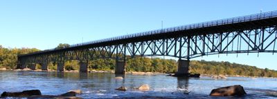
Boulevard Bridge, Road bridge in Richmond, United States.

Description

The Boulevard Bridge is a steel and concrete road bridge that crosses the James River in Richmond, linking the northern and southern parts of the city. The structure carries both vehicles and pedestrians between these sections and serves as an important connection in the city's transportation network.

History

The bridge was built in 1925 to provide access to the developing Westover Hills neighborhood in South Richmond. This construction was a turning point that allowed the city to expand southward and connect previously isolated areas.

Culture

Local residents call this bridge the Nickel Bridge, a name that comes from the original five-cent toll charged in the early 1900s. This nickname remains part of everyday conversation and shows how the place's past is woven into how people think about it.

Practical

Both vehicles and pedestrians can use the bridge, with access available throughout the day during regular operating hours. Expect heavier traffic during rush hours in the morning and evening, so crossing at other times of day tends to be smoother.

Did you know?

Originally, the toll booth sat at the center of the bridge until it was moved in the 1960s. This change greatly improved traffic flow and fundamentally altered how people experienced crossing the river.

Location
Official opening
1925
GPS coordinates
37.53170,-77.48390
Latest update
December 10, 2025 20:07

AroundUs brings together thousands of curated places, local tips, and hidden gems, enriched daily by 60,000 contributors worldwide. Discover all places nearby (Virginia).

Around this place
Hollywood Cemetery
United States of America

Hollywood Cemetery

2.3 km
Maymont Park
United States of America

Maymont Park

671 m
James River and Kanawha Canal
United States of America

James River and Kanawha Canal

4.6 km
City Stadium
United States of America

City Stadium

2 km
Byrd Theatre
United States of America

Byrd Theatre

2.4 km
Byrd Park
United States of America

Byrd Park

1 km
Forest Hill Park
United States of America

Forest Hill Park

1.7 km
Statue of Christopher Columbus
United States of America

Statue of Christopher Columbus

1.8 km
CSX A-Line Bridge
United States of America

CSX A-Line Bridge

1 km
James River Park System
United States of America

James River Park System

393 m
Robinson House
United States of America

Robinson House

2.7 km
New Pump-House
United States of America

New Pump-House

451 m
Cary Street Park and Shop Center
United States of America

Cary Street Park and Shop Center

2.4 km
Confederate Memorial Chapel
United States of America

Confederate Memorial Chapel

2.8 km
Stonewall Jackson School
United States of America

Stonewall Jackson School

2.7 km
2900 Block Grove Avenue Historic District
United States of America

2900 Block Grove Avenue Historic District

2.7 km
Belle Isle railroad bridge
United States of America

Belle Isle railroad bridge

2.8 km
Forest Hill Historic District
United States of America

Forest Hill Historic District

1.5 km
Randolph School
United States of America

Randolph School

2.4 km
Marburg
United States of America

Marburg

1.1 km
Byrd Park Court Historic District
United States of America

Byrd Park Court Historic District

1.7 km
John Whitworth House
United States of America

John Whitworth House

2.7 km
St. Sophia Home of the Little Sisters of the Poor
United States of America

St. Sophia Home of the Little Sisters of the Poor

2.8 km
Carillon Neighborhood Historic District
United States of America

Carillon Neighborhood Historic District

1.3 km
Virginia Commission for the Blind
United States of America

Virginia Commission for the Blind

2.3 km
James Monroe Tomb
United States of America

James Monroe Tomb

2.4 km
Virginia Museum of Fine Arts Sculpture Garden
United States of America

Virginia Museum of Fine Arts Sculpture Garden

2.8 km
Boulevard Historic District
United States of America

Boulevard Historic District

2.4 km
Show the full map
« Boulevard Bridge - Road bridge in Richmond, United States » is provided by Around Us (aroundus.com). Images and texts are derived from Wikimedia project under a Creative Commons license. You are allowed to copy, distribute, and modify copies of this page, under the conditions set by the license, as long as this note is clearly visible.

Discover hidden gems everywhere you go!

From secret cafés to breathtaking viewpoints, skip the crowded tourist spots and find places that match your style. Our app makes it easy with voice search, smart filtering, route optimization, and insider tips from travelers worldwide. Download now for the complete mobile experience.

Around Us App Screenshot

A unique approach to discovering new places

Le Figaro

All the places worth exploring

France Info

A tailor-made excursion in just a few clicks

20 Minutes

Around Us
Travel Guide & Maps
Download

Send to your phone

QR Code
1

Open the camera app on your mobile.

2

Point at the QR code with your camera. A notification will appear.

3

Tap the notification to open the link.