Enable Location

We need your location to show you interesting places around you

Discover nearby places

Find interesting locations and hidden gems around you

Precise directions

Get accurate directions and distances to places

Your location is never shared with other users. It's only used when you tap the location button.

Blair High School

Log in to your account

Start exploring — it's free

Trusted by 62,469 travelers worldwide

Continue with Google
Continue with Apple
or

We will send you a code to connect

By continuing, you accept our Terms and Conditions and our Privacy Policy

Check your inbox

We've sent a pincode in your inbox. Please enter the code below.

Blair High School, high school in Nebraska, United States

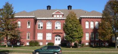
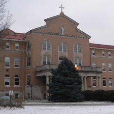
Blair High School is a secondary school in Blair, Nebraska, with buildings spanning different construction periods. The original 1899 building displays Romanesque architecture, while a 1929 addition introduced Colonial Revival features and the 1970 school building provides modern spaces for roughly 750 students.

The school was founded in 1899 and added to the National Register of Historic Places in 1991, recognizing its historical importance. The original building was later expanded in 1929 and 1970, reflecting the community's growing educational needs over time.

The school's name references the Bears mascot, which holds significance in the local school community and appears throughout campus life. This identity is reinforced by the purple and white school colors, visible during athletic events and student gatherings.

The school is located on North 10th Street and is easy for families and visitors to find and access. The campus blends older and newer structures, making it straightforward to navigate the grounds.

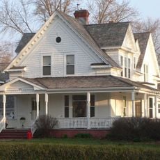
The original school building from 1899 was later converted into apartments, offices, and a social hall, so it no longer functions as classrooms. This adaptive reuse preserved the historic structure while giving it new purpose.

The community of curious travelers

AroundUs brings together thousands of curated places, local tips, and hidden gems, enriched daily by 60,000 contributors worldwide.

Start exploring
Location
Architects
John Latenser, Sr.
Architectural style
Colonial Revival architecture
GPS coordinates
41.54000,-96.13670
Latest update
February 9, 2026 08:19
Around this place
Fort Atkinson
United States of America

Fort Atkinson

14.2 km
Fort Atkinson State Historical Park
United States of America

Fort Atkinson State Historical Park

13.9 km
Hummel Park
United States of America

Hummel Park

24 km
DeSoto National Wildlife Refuge
United States of America

DeSoto National Wildlife Refuge

10.1 km
Glenn Cunningham Lake
United States of America

Glenn Cunningham Lake

22.1 km
Florence Mill
United States of America

Florence Mill

26.3 km
General Crook House
United States of America

General Crook House

26.9 km
Bank of Florence Museum
United States of America

Bank of Florence Museum

26.9 km
Neale Woods
United States of America

Neale Woods

22.7 km
Ackerhurst Dairy Barn
United States of America

Ackerhurst Dairy Barn

22.7 km
Blair Bridge
United States of America

Blair Bridge

3.7 km
Blair Bridge
United States of America

Blair Bridge

3.6 km
Hitchcock Nature Center
United States of America

Hitchcock Nature Center

26.7 km
H.S.M. Spielman House
United States of America

H.S.M. Spielman House

26.8 km
Congregational Church of Blair
United States of America

Congregational Church of Blair

114 m
Washington County Courthouse
United States of America

Washington County Courthouse

142 m
Tekamah Carnegie Library
United States of America

Tekamah Carnegie Library

27.3 km
Alfred H. and Sarah Frahm House
United States of America

Alfred H. and Sarah Frahm House

13.2 km
Fontanelle Township Hall
United States of America

Fontanelle Township Hall

24.2 km
Abraham Castetter House
United States of America

Abraham Castetter House

304 m
Burt County State Bank
United States of America

Burt County State Bank

27.2 km
C.C. Crowell Jr. House
United States of America

C.C. Crowell Jr. House

832 m
Neale Woods
United States of America

Neale Woods

22.5 km
Winter Quarters Mill Museum
United States of America

Winter Quarters Mill Museum

26.3 km
Florence Mill Museum
United States of America

Florence Mill Museum

26.3 km
Harrison County Historical Village & Iowa Welcome Center
United States of America

Harrison County Historical Village & Iowa Welcome Center

24.5 km
Notre Dame Academy and Convent
United States of America

Notre Dame Academy and Convent

26.9 km
Mormon Bridge
United States of America

Mormon Bridge

26.3 km
Show the full map
« Blair High School - high school in Nebraska, United States » is provided by Around Us (aroundus.com). Images and texts are derived from Wikimedia project under a Creative Commons license. You are allowed to copy, distribute, and modify copies of this page, under the conditions set by the license, as long as this note is clearly visible.

Discover hidden gems everywhere you go!

From secret cafés to breathtaking viewpoints, skip the crowded tourist spots and find places that match your style. Our app makes it easy with voice search, smart filtering, route optimization, and insider tips from travelers worldwide. Download now for the complete mobile experience.

Around Us App Screenshot

A unique approach to discovering new places

Le Figaro

All the places worth exploring

France Info

A tailor-made excursion in just a few clicks

20 Minutes

Around Us
Travel Guide & Maps
Download

Send to your phone

QR Code
1

Open the camera app on your mobile.

2

Point at the QR code with your camera. A notification will appear.

3

Tap the notification to open the link.