Enable Location

We need your location to show you interesting places around you

Discover nearby places

Find interesting locations and hidden gems around you

Precise directions

Get accurate directions and distances to places

Your location is never shared with other users. It's only used when you tap the location button.

Keya Paha County High School

Log in to your account

Start exploring — it's free

Trusted by 62,857 travelers worldwide

Continue with Google
Continue with Apple
or

We will send you a code to connect

By continuing, you accept our Terms and Conditions and our Privacy Policy

Check your inbox

We've sent a pincode in your inbox. Please enter the code below.

Keya Paha County High School, high school in Nebraska, United States

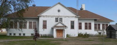
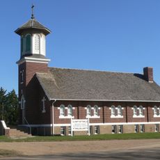
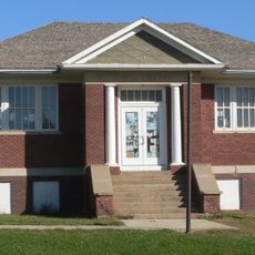
Keya Paha County High School is a historic school building in Springview, Nebraska, constructed between 1915 and 1916 to serve students across the entire county. The structure displays simple, functional architecture with sturdy brick walls and high ceilings characteristic of early 20th-century rural schools.

The school building was constructed following an 1913 law requiring counties to establish high schools for rural children, opening on January 26, 1916. An addition was built in 1929, and the building served as a school until 1965 when it transitioned to housing a local historical museum.

The school served as a gathering place for the community across generations, hosting events that brought families together and shaped local identity. Today, visitors can sense how education and social life were deeply connected in this rural area.

The building is located in Springview on Courthouse Drive near Nebraska Highway 12, making it easy to find. Access is straightforward and the spaces are well-maintained, allowing visitors to comfortably explore the historical displays inside.

The school building was completed in just five months and opened on January 26, 1916, a remarkably fast construction for a public building of that era. This efficiency reflects the urgent need to provide rural students with access to education.

The community of curious travelers

AroundUs brings together thousands of curated places, local tips, and hidden gems, enriched daily by 60,000 contributors worldwide.

Start exploring
Location
GPS coordinates
42.82560,-99.74670
Latest update
February 9, 2026 07:45
Around this place
Smith Falls
United States of America

Smith Falls

47 km
Niobrara National Scenic River
United States of America

Niobrara National Scenic River

47 km
Valentine National Wildlife Refuge
United States of America

Valentine National Wildlife Refuge

77.1 km
Fort Niobrara National Wildlife Refuge
United States of America

Fort Niobrara National Wildlife Refuge

57.5 km
Snake Creek Recreation Area
United States of America

Snake Creek Recreation Area

80.9 km
Niobrara Valley Preserve
United States of America

Niobrara Valley Preserve

23.5 km
United States of America

White Horse Ranch

56.4 km
Bryan Bridge
United States of America

Bryan Bridge

63.8 km
Brewer Bridge
United States of America

Brewer Bridge

42.8 km
Carns State Aid Bridge
United States of America

Carns State Aid Bridge

24 km
Bell Bridge
United States of America

Bell Bridge

47.6 km
St. Augustine Church
United States of America

St. Augustine Church

49.3 km
Cherry County Courthouse
United States of America

Cherry County Courthouse

65.9 km
Valentine Public School
United States of America

Valentine Public School

65.5 km
Lewis Bridge
United States of America

Lewis Bridge

21.2 km
Adamson Bridge
United States of America

Adamson Bridge

75.6 km
St. John's Catholic Church
United States of America

St. John's Catholic Church

31.6 km
Borman Bridge
United States of America

Borman Bridge

63.3 km
Tripp County Veteran's Memorial
United States of America

Tripp County Veteran's Memorial

61.9 km
Berry State Aid Bridge
United States of America

Berry State Aid Bridge

50.9 km
Herrick Elevator
United States of America

Herrick Elevator

56.7 km
Church of Christ in LaRoche Township
United States of America

Church of Christ in LaRoche Township

88.5 km
Brantly Sturdevant House
United States of America

Brantly Sturdevant House

71 km
F.M. Walcott House
United States of America

F.M. Walcott House

66.1 km
Dallas Carnegie Library
United States of America

Dallas Carnegie Library

49.4 km
Rock County Courthouse
United States of America

Rock County Courthouse

32.1 km
Manthey Barn
United States of America

Manthey Barn

43.3 km
Distrito electoral de Valentine (condado de Cherry, Nebraska)
United States of America

Distrito electoral de Valentine (condado de Cherry, Nebraska)

63.9 km
Show the full map
« Keya Paha County High School - high school in Nebraska, United States » is provided by Around Us (aroundus.com). Images and texts are derived from Wikimedia project under a Creative Commons license. You are allowed to copy, distribute, and modify copies of this page, under the conditions set by the license, as long as this note is clearly visible.

Discover hidden gems everywhere you go!

From secret cafés to breathtaking viewpoints, skip the crowded tourist spots and find places that match your style. Our app makes it easy with voice search, smart filtering, route optimization, and insider tips from travelers worldwide. Download now for the complete mobile experience.

Around Us App Screenshot

A unique approach to discovering new places

Le Figaro

All the places worth exploring

France Info

A tailor-made excursion in just a few clicks

20 Minutes

Around Us
Travel Guide & Maps
Download

Send to your phone

QR Code
1

Open the camera app on your mobile.

2

Point at the QR code with your camera. A notification will appear.

3

Tap the notification to open the link.