Enable Location

We need your location to show you interesting places around you

Discover nearby places

Find interesting locations and hidden gems around you

Precise directions

Get accurate directions and distances to places

Your location is never shared with other users. It's only used when you tap the location button.

Mt. Torry Furnace

Log in to your account

Start exploring — it's free

Trusted by 61,899 travelers worldwide

Continue with Google
Continue with Apple
or

We will send you a code to connect

By continuing, you accept our Terms and Conditions and our Privacy Policy

Check your inbox

We've sent a pincode in your inbox. Please enter the code below.

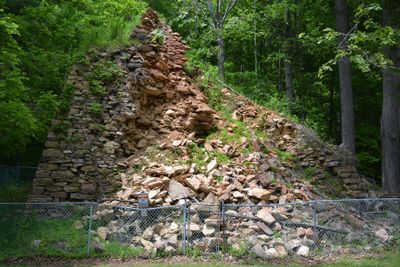
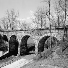
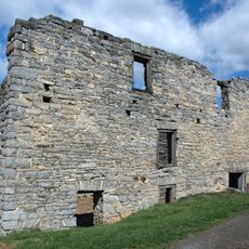
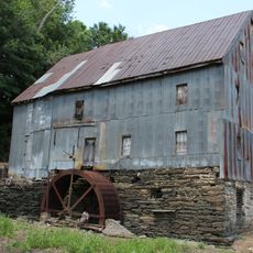
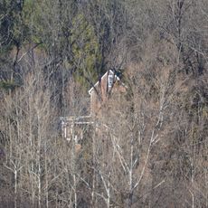
Mt. Torry Furnace, Iron furnace in Augusta County, Virginia

Mt. Torry Furnace is a stone iron furnace in the George Washington National Forest near Waynesboro. The structure was built with thick stone walls and includes functional elements such as a tap arch and a charging bridge for moving materials into the furnace.

The furnace was built in 1804 and initially used older iron production methods. It was reactivated during the Civil War to provide metal for Confederate forces and continued operation until 1884.

The furnace represents the beginnings of American iron production and shows how works adapted their methods over time. Visitors can see today how early metalworkers shaped this landscape through their craft.

The site is located southwest of Waynesboro and is accessible by road through the national forest. Since it sits in a wooded setting, wear appropriate clothing and sturdy shoes if you plan to explore the immediate surroundings.

The furnace features a notable technical detail for its era: a wide tap arch reinforced with metal supports. This design allowed workers to drain molten iron in a controlled manner, improving efficiency during operations.

The community of curious travelers

AroundUs brings together thousands of curated places, local tips, and hidden gems, enriched daily by 60,000 contributors worldwide.

Start exploring
Location
GPS coordinates
37.94530,-78.96470
Latest update
December 14, 2025 18:46
Around this place
Swannanoa
United States of America

Swannanoa

12.5 km
Crabtree Falls
United States of America

Crabtree Falls

14.5 km
Rockfish Gap
United States of America

Rockfish Gap

13.5 km
General Electric Specialty Control Plant
United States of America

General Electric Specialty Control Plant

18.4 km
Shenandoah Acres
United States of America

Shenandoah Acres

8.1 km
The Priest
United States of America

The Priest

16.4 km
Saint Mary's Wilderness
United States of America

Saint Mary's Wilderness

15.2 km
Three Ridges Wilderness
United States of America

Three Ridges Wilderness

9.2 km
Tinkling Spring Presbyterian Church
United States of America

Tinkling Spring Presbyterian Church

15.6 km
Emmanuel Church
United States of America

Emmanuel Church

20.2 km
Casa Maria
United States of America

Casa Maria

20.2 km
United States of America

Tree Streets Historic District

14.5 km
Valley Railroad Stone Bridge
United States of America

Valley Railroad Stone Bridge

18.8 km
Virginia Metalcrafters Historic District
United States of America

Virginia Metalcrafters Historic District

15.5 km
Plumb House
United States of America

Plumb House

15.1 km
Ramsay
United States of America

Ramsay

19.9 km
Bellevue
United States of America

Bellevue

19.8 km
Harper House
United States of America

Harper House

11.6 km
Bare House and Mill
United States of America

Bare House and Mill

14.5 km
Wintergreen Country Store
United States of America

Wintergreen Country Store

8.8 km
Piedmont
United States of America

Piedmont

19.8 km
Waynesboro Downtown Historic District
United States of America

Waynesboro Downtown Historic District

15.2 km
Rose Cliff
United States of America

Rose Cliff

14.1 km
Tyro Mill
United States of America

Tyro Mill

14.6 km
Chapel Hill
United States of America

Chapel Hill

16.5 km
Port Republic Road Historic District
United States of America

Port Republic Road Historic District

15.9 km
River Bluff
United States of America

River Bluff

8.9 km
South Rockfish Valley Rural Historic District
United States of America

South Rockfish Valley Rural Historic District

10.3 km
Show the full map
« Mt. Torry Furnace - Iron furnace in Augusta County, Virginia » is provided by Around Us (aroundus.com). Images and texts are derived from Wikimedia project under a Creative Commons license. You are allowed to copy, distribute, and modify copies of this page, under the conditions set by the license, as long as this note is clearly visible.

Discover hidden gems everywhere you go!

From secret cafés to breathtaking viewpoints, skip the crowded tourist spots and find places that match your style. Our app makes it easy with voice search, smart filtering, route optimization, and insider tips from travelers worldwide. Download now for the complete mobile experience.

Around Us App Screenshot

A unique approach to discovering new places

Le Figaro

All the places worth exploring

France Info

A tailor-made excursion in just a few clicks

20 Minutes

Around Us
Travel Guide & Maps
Download

Send to your phone

QR Code
1

Open the camera app on your mobile.

2

Point at the QR code with your camera. A notification will appear.

3

Tap the notification to open the link.