Enable Location

We need your location to show you interesting places around you

Discover nearby places

Find interesting locations and hidden gems around you

Precise directions

Get accurate directions and distances to places

Your location is never shared with other users. It's only used when you tap the location button.

Mound Cemetery Mound

Log in to your account

Start exploring — it's free

Trusted by 63,590 travelers worldwide

Continue with Google
Continue with Apple
or

We will send you a code to connect

By continuing, you accept our Terms and Conditions and our Privacy Policy

Check your inbox

We've sent a pincode in your inbox. Please enter the code below.

Discussion Reviews 1 Photos
1.2k Popularity

Mound Cemetery Mound, Native American mound in central Meigs County, Ohio, United States

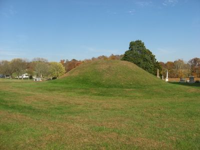
The Mound Cemetery Mound is a large prehistoric earthwork located north of Chester in Meigs County, Ohio. It has a gentle, rounded shape rising from a grass-covered cemetery setting with trees, and its inner structure remains unknown because archaeologists have never excavated it.

The mound was built approximately 2500 years ago by the Adena people, an early Woodland culture active from about 800 BCE to 100 CE in the region. While many similar structures in Meigs County were destroyed by farming, this one remained intact because the cemetery grounds protected it.

The mound takes its name from its location within a cemetery where local communities have buried their dead for generations. The presence of both ancient and modern graves surrounding this prehistoric earthwork shows how the place has long served as a burial ground across different periods.

The mound lies a short drive north of Chester and is accessible during daylight hours, with the surrounding cemetery grounds offering space to walk and observe. Visitors should treat the site with respect and avoid climbing on the mound, as this could damage the delicate structure.

Unlike many other Adena mounds, this one was never excavated, so it may still contain original wooden structures or objects from thousands of years ago. This undisturbed state makes it valuable for future archaeologists who could study it with advanced techniques.

The community of curious travelers

AroundUs brings together thousands of curated places, local tips, and hidden gems, enriched daily by 60,000 contributors worldwide.

Start exploring
Location
GPS coordinates
39.11341,-81.92319
Latest update
February 9, 2026 07:45
Around this place
Athens Lunatic Asylum
United States of America

Athens Lunatic Asylum

28.1 km
Peden Stadium
United States of America

Peden Stadium

27.8 km
Strouds Run State Park
United States of America

Strouds Run State Park

26.7 km
Ravenswood Bridge
United States of America

Ravenswood Bridge

24.4 km
Pomeroy–Mason Bridge
United States of America

Pomeroy–Mason Bridge

15.1 km
United States of America

Lake Snowden

27.3 km
Belleville Lock and Dam
United States of America

Belleville Lock and Dam

15.8 km
United States of America

Marie J. Desonier State Nature Preserve

14.7 km
John Calhoun Baker University Center
United States of America

John Calhoun Baker University Center

28.1 km
Racine Lock and Dam
United States of America

Racine Lock and Dam

22 km
Meigs County Courthouse
United States of America

Meigs County Courthouse

13.5 km
Athens State Hospital Cow Barn
United States of America

Athens State Hospital Cow Barn

27.8 km
Sawyer-Curtis House
United States of America

Sawyer-Curtis House

25.5 km
Ravenswood "Old Town" Historic District
United States of America

Ravenswood "Old Town" Historic District

23.1 km
Walter Curtis House
United States of America

Walter Curtis House

21.9 km
The Gold Houses
United States of America

The Gold Houses

13.2 km
John Downing, Jr., House
United States of America

John Downing, Jr., House

16.3 km
Blackwood Covered Bridge
United States of America

Blackwood Covered Bridge

10.3 km
Middleport Public Library
United States of America

Middleport Public Library

16.7 km
Shumaker-Lewis House
United States of America

Shumaker-Lewis House

14.1 km
Savage-Stewart House
United States of America

Savage-Stewart House

22.6 km
William H. Grant House
United States of America

William H. Grant House

17.1 km
Powell-Redmond House
United States of America

Powell-Redmond House

16 km
Lemley-Wood-Sayer House
United States of America

Lemley-Wood-Sayer House

23.1 km
Rankin Octagonal Barn
United States of America

Rankin Octagonal Barn

27.1 km
Kennedy Museum of Art
United States of America

Kennedy Museum of Art

28.1 km
West Virginia State Farm Museum
United States of America

West Virginia State Farm Museum

25.9 km
Skatopia/CIA
United States of America

Skatopia/CIA

20.1 km
Show the full map
Reviews
Share your experience

No review yet

Discussions
Start a discussion...

No discussion yet

« Mound Cemetery Mound - Native American mound in central Meigs County, Ohio, United States » is provided by Around Us (aroundus.com). Images and texts are derived from Wikimedia project under a Creative Commons license. You are allowed to copy, distribute, and modify copies of this page, under the conditions set by the license, as long as this note is clearly visible.

Discover hidden gems everywhere you go!

From secret cafés to breathtaking viewpoints, skip the crowded tourist spots and find places that match your style. Our app makes it easy with voice search, smart filtering, route optimization, and insider tips from travelers worldwide. Download now for the complete mobile experience.

Around Us App Screenshot

A unique approach to discovering new places

Le Figaro

All the places worth exploring

France Info

A tailor-made excursion in just a few clicks

20 Minutes

Around Us
Travel Guide & Maps
Download

Send to your phone

QR Code
1

Open the camera app on your mobile.

2

Point at the QR code with your camera. A notification will appear.

3

Tap the notification to open the link.