Enable Location

We need your location to show you interesting places around you

Discover nearby places

Find interesting locations and hidden gems around you

Precise directions

Get accurate directions and distances to places

Your location is never shared with other users. It's only used when you tap the location button.

Indian Well State Park

Log in to your account

Start exploring — it's free

Trusted by 61,579 travelers worldwide

Continue with Google
Continue with Apple
or

We will send you a code to connect

By continuing, you accept our Terms and Conditions and our Privacy Policy

Check your inbox

We've sent a pincode in your inbox. Please enter the code below.

Indian Well State Park

Indian Well State Park, Connecticut state park in Shelton, US.

Description

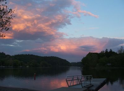
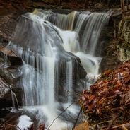
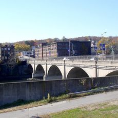
Indian Well State Park spans 153 acres (62 hectares) along Lake Housatonic with a sandy beach, shaded picnic areas, and a waterfall dropping into a splash pool. The grounds include a boat launch for lake access and swimming areas staffed with lifeguards.

History

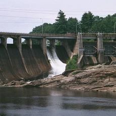
The State Park and Forest Commission established this park in 1928 by acquiring 150 acres of riverfront land from the Ousatonic Water Power Company. This purchase marked an early effort to preserve the water and land resources of the region.

Culture

The New Haven Rowing Club has made this location their home for annual regattas since the 1990s, turning it into a gathering place for rowing competitions. The water attracts competitors from across the region who return year after year to race here.

Practical

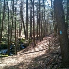
The park is best explored on foot with multiple trails connecting to the blue-blazed Paugussett Trail system that winds through the area. Wear sturdy shoes since paths can be uneven and wet, especially near the water features.

Did you know?

Lake Housatonic within the park holds a Bass Management Lake designation that supports populations of smallmouth bass, white catfish, and American eel in the same waters. Anglers visiting specifically seek out these target species that thrive here due to the specialized management program.

Location
Inception
1928
Elevation above the sea
25 m
GPS coordinates
41.33690,-73.12190
Latest update
December 6, 2025 17:43

AroundUs brings together thousands of curated places, local tips, and hidden gems, enriched daily by 60,000 contributors worldwide. Discover all places nearby (Fairfield County).

Nature sites and historic places in Connecticut

Connecticut combines different landscapes from the coast to the mountains with a range of historic sites. The region includes state parks with waterfalls like Kent Falls and Wadsworth Falls, extensive forested areas, and conservation lands. Visitors can hike through White Memorial Conservation...

Around this place
Sterling Opera House
United States of America

Sterling Opera House

3.2 km
Stevenson Dam Bridge
United States of America

Stevenson Dam Bridge

6.6 km
Paugussett Trail
United States of America

Paugussett Trail

5.8 km
Osbornedale State Park
United States of America

Osbornedale State Park

1.6 km
David Humphreys House
United States of America

David Humphreys House

4 km
United States of America

Pomperaug Trail

5.8 km
Kraus Corset Factory
United States of America

Kraus Corset Factory

3.2 km
Plumb Memorial Library
United States of America

Plumb Memorial Library

2.8 km
Derby-Shelton Bridge
United States of America

Derby-Shelton Bridge

3.3 km
Osbornedale
United States of America

Osbornedale

937 m
Commodore Isaac Hull Memorial Bridge
United States of America

Commodore Isaac Hull Memorial Bridge

3.8 km
Westville Village Historic District
United States of America

Westville Village Historic District

4.3 km
Woodbridge Green Historic District
United States of America

Woodbridge Green Historic District

9.3 km
Monroe Center Historic District
United States of America

Monroe Center Historic District

7.1 km
Ansonia Library
United States of America

Ansonia Library

3.9 km
United States Post Office–Ansonia Main
United States of America

United States Post Office–Ansonia Main

3.7 km
Ephraim Wheeler House
United States of America

Ephraim Wheeler House

9.3 km
United States of America

Upper Main Street Historic District

3.6 km
Daniel Basset House
United States of America

Daniel Basset House

6.5 km
Chatfield Farmstead
United States of America

Chatfield Farmstead

9.1 km
John I. Howe House
United States of America

John I. Howe House

3.3 km
Harcourt Wood Memorial Library
United States of America

Harcourt Wood Memorial Library

3 km
Richard Mansfield House
United States of America

Richard Mansfield House

4.3 km
Sanford-Humphreys House
United States of America

Sanford-Humphreys House

7.3 km
Kaatz Icehouse
United States of America

Kaatz Icehouse

10 km
Strand Theatre
United States of America

Strand Theatre

7.8 km
Housatonic River Bridge
United States of America

Housatonic River Bridge

3.5 km
Naugatuck River Bridge
United States of America

Naugatuck River Bridge

4.1 km
Show the full map
« Indian Well State Park - Connecticut state park in Shelton, US » is provided by Around Us (aroundus.com). Images and texts are derived from Wikimedia project under a Creative Commons license. You are allowed to copy, distribute, and modify copies of this page, under the conditions set by the license, as long as this note is clearly visible.

Discover hidden gems everywhere you go!

From secret cafés to breathtaking viewpoints, skip the crowded tourist spots and find places that match your style. Our app makes it easy with voice search, smart filtering, route optimization, and insider tips from travelers worldwide. Download now for the complete mobile experience.

Around Us App Screenshot

A unique approach to discovering new places

Le Figaro

All the places worth exploring

France Info

A tailor-made excursion in just a few clicks

20 Minutes

Around Us
Travel Guide & Maps
Download

Send to your phone

QR Code
1

Open the camera app on your mobile.

2

Point at the QR code with your camera. A notification will appear.

3

Tap the notification to open the link.