·

Enable Location

We need your location to show you interesting places around you

Discover nearby places

Find interesting locations and hidden gems around you

Precise directions

Get accurate directions and distances to places

Your location is never shared with other users. It's only used when you tap the location button.

Log in to your account

Start exploring — it's free

Trusted by 62,739 travelers worldwide

Continue with Google
Continue with Apple
or

We will send you a code to connect

By continuing, you accept our Terms and Conditions and our Privacy Policy

Check your inbox

We've sent a pincode in your inbox. Please enter the code below.

Deer Lake

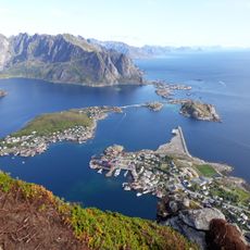
Deer Lake, lake in Marquette County, Michigan, USA

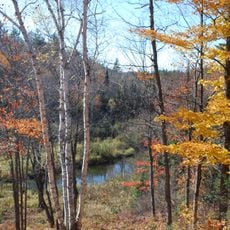
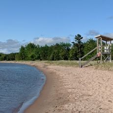
Deer Lake is a reservoir in Marquette County in northern Michigan that stretches over a broad area surrounded by forests and open land. The water is cool and clear enough to see fish swimming beneath the surface, and the shoreline features sandy areas mixed with wooded sections and natural curves.

The lake became contaminated with mercury during the 20th century, which government agencies documented in the 1980s and led to fishing restrictions. After cleanup efforts improved water quality, the lake was officially removed from the contamination list in 2014, marking a significant recovery milestone.

Visitors should bring their own supplies such as water and snacks, especially if planning to spend several hours at the lake. The lake is easily accessible by local roads leading directly to its shores, with simple areas for relaxing, picnicking, or enjoying nature without commercial facilities nearby.

The lake was one of the first two in Michigan to be removed from the contamination list in 2014, showing its recovery after decades of pollution. This recognition makes it a notable example of successful remediation efforts in the region.

The community of curious travelers

AroundUs brings together thousands of curated places, local tips, and hidden gems, enriched daily by 60,000 contributors worldwide.

Start exploring
Location
Elevation above the sea
1,407 ft
GPS coordinates
46.52860,-87.68610
Latest update
February 9, 2026 08:20
Around this place
Superior Dome
United States of America

Superior Dome

22.7 km
Granot Loma
United States of America

Granot Loma

21.7 km
Marquette Branch Prison
United States of America

Marquette Branch Prison

23.3 km
National Ski Hall of Fame
United States of America

National Ski Hall of Fame

3.2 km
Holy Family Orphanage
United States of America

Holy Family Orphanage

21.7 km
Cliffs Shaft Mine Museum
United States of America

Cliffs Shaft Mine Museum

4.3 km
Peter White Public Library
United States of America

Peter White Public Library

22.5 km
Mather Inn
United States of America

Mather Inn

4.3 km
Marquette County Courthouse
United States of America

Marquette County Courthouse

22.2 km
Palestra, The Marquette
United States of America

Palestra, The Marquette

22.5 km
Vista Theater
United States of America

Vista Theater

12.7 km
Marquette City Hall
United States of America

Marquette City Hall

22.3 km
Coaster II
United States of America

Coaster II

22.6 km
Savings Bank Building
United States of America

Savings Bank Building

22.5 km
Call House
United States of America

Call House

23.2 km
Arch and Ridge Streets Historic District
United States of America

Arch and Ridge Streets Historic District

23.1 km
Carp River Forge
United States of America

Carp River Forge

9.3 km
Longyear Building
United States of America

Longyear Building

22.6 km
Sundberg Block
United States of America

Sundberg Block

6.5 km
Ishpeming Municipal Building
United States of America

Ishpeming Municipal Building

4.7 km
Cleveland Mine Engine House Number 3
United States of America

Cleveland Mine Engine House Number 3

4.9 km
Longyear Hall of Pedagogy
United States of America

Longyear Hall of Pedagogy

22.3 km
Ishpeming Main Street Historic District
United States of America

Ishpeming Main Street Historic District

4.6 km
Marquette Maritime Museum
United States of America

Marquette Maritime Museum

23.6 km
Reine utsiktspunkt
Norway

Reine utsiktspunkt

15.1 km
Dead River Beach
United States of America

Dead River Beach

23.2 km
Marquette Regional History Center
United States of America

Marquette Regional History Center

22.3 km
Negaunee State Bank Building
United States of America

Negaunee State Bank Building

6.7 km
Show the full map
« Deer Lake - lake in Marquette County, Michigan, USA » is provided by Around Us (aroundus.com). Images and texts are derived from Wikimedia project under a Creative Commons license. You are allowed to copy, distribute, and modify copies of this page, under the conditions set by the license, as long as this note is clearly visible.

Discover hidden gems everywhere you go!

From secret cafés to breathtaking viewpoints, skip the crowded tourist spots and find places that match your style. Our app makes it easy with voice search, smart filtering, route optimization, and insider tips from travelers worldwide. Download now for the complete mobile experience.

Around Us App Screenshot

A unique approach to discovering new places

Le Figaro

All the places worth exploring

France Info

A tailor-made excursion in just a few clicks

20 Minutes

Around Us
Travel Guide & Maps
Download

Send to your phone

QR Code
1

Open the camera app on your mobile.

2

Point at the QR code with your camera. A notification will appear.

3

Tap the notification to open the link.