Enable Location

We need your location to show you interesting places around you

Discover nearby places

Find interesting locations and hidden gems around you

Precise directions

Get accurate directions and distances to places

Your location is never shared with other users. It's only used when you tap the location button.

Log in to your account

Start exploring — it's free

Trusted by 63,323 travelers worldwide

Continue with Google
Continue with Apple
or

We will send you a code to connect

By continuing, you accept our Terms and Conditions and our Privacy Policy

Check your inbox

We've sent a pincode in your inbox. Please enter the code below.

State Game Lands Number 37
Discussion Reviews Photo
1.5k Popularity

State Game Lands Number 37, State managed wildlife lands in Tioga County, Pennsylvania.

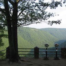
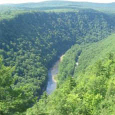
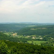
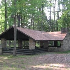
State Game Lands Number 37 is a government-managed wildlife area in Tioga County that encompasses forests, fields, and wetlands across multiple townships. The terrain includes an extensive trail network that connects through these varied landscapes.

The Pennsylvania Game Commission established this protected area as part of a broader conservation initiative to maintain and manage wildlife populations. Official recognition came in 1990.

This land functions as a learning space where outdoor groups conduct educational programs on wildlife management and environmental stewardship. Visitors can directly observe how forest ecosystems are maintained and protected.

Visitors need appropriate licenses for hunting and should wear orange safety clothing during hunting seasons. The well-developed trail system allows exploration through different landscape types, and sturdy footwear is recommended.

The area spans an elevation range of roughly 1,100 to 2,290 feet (335 to 700 meters), creating different climate zones that support distinct wildlife populations. These elevation differences create habitats that vary significantly from one another.

The community of curious travelers

AroundUs brings together thousands of curated places, local tips, and hidden gems, enriched daily by 60,000 contributors worldwide.

Start exploring
Location
Location
GPS coordinates
41.88333,-77.16639
Latest update
December 14, 2025 15:02
Around this place
Corning Museum of Glass
United States of America

Corning Museum of Glass

31.1 km
Colton Point State Park
United States of America

Colton Point State Park

32.1 km
Leonard Harrison State Park
United States of America

Leonard Harrison State Park

31.7 km
Rockwell Museum
United States of America

Rockwell Museum

30.4 km
Pinnacle State Park and Golf Course
United States of America

Pinnacle State Park and Golf Course

23.9 km
Jenning's Tavern
United States of America

Jenning's Tavern

31 km
Troy Public High School
United States of America

Troy Public High School

33.3 km
Robinson House
United States of America

Robinson House

19 km
Market Street Historic District
United States of America

Market Street Historic District

30.4 km
World War Memorial Library
United States of America

World War Memorial Library

30.2 km
Southside Historic District
United States of America

Southside Historic District

29.9 km
First Baptist Church of Painted Post
United States of America

First Baptist Church of Painted Post

31.2 km
Near Westside Historic District
United States of America

Near Westside Historic District

36.9 km
Wellsboro Armory
United States of America

Wellsboro Armory

18.9 km
Sunbury Historic District
United States of America

Sunbury Historic District

31 km
Wellsboro Historic District
United States of America

Wellsboro Historic District

18.7 km
Corning Armory
United States of America

Corning Armory

30.9 km
Parkhurst Memorial Presbyterian Church
United States of America

Parkhurst Memorial Presbyterian Church

17 km
James Ford House
United States of America

James Ford House

12.9 km
Main Street Historic District
United States of America

Main Street Historic District

25.4 km
Maple Street Historic District
United States of America

Maple Street Historic District

25.7 km
Van Dyne Civic Building
United States of America

Van Dyne Civic Building

33.3 km
Collins Observatory
United States of America

Collins Observatory

27.1 km
William Wombough House
United States of America

William Wombough House

26.1 km
Colton Point State Park Historic District
United States of America

Colton Point State Park Historic District

32 km
Corning Museum of Glass Welcome Center
United States of America

Corning Museum of Glass Welcome Center

31.4 km
Arcadia Theatre
United States of America

Arcadia Theatre

18.6 km
Judge John Ryon House
United States of America

Judge John Ryon House

12.8 km
Show the full map
Reviews
Share your experience

No review yet

Discussions
Start a discussion...

No discussion yet

« State Game Lands Number 37 - State managed wildlife lands in Tioga County, Pennsylvania » is provided by Around Us (aroundus.com). Images and texts are derived from Wikimedia project under a Creative Commons license. You are allowed to copy, distribute, and modify copies of this page, under the conditions set by the license, as long as this note is clearly visible.

Discover hidden gems everywhere you go!

From secret cafés to breathtaking viewpoints, skip the crowded tourist spots and find places that match your style. Our app makes it easy with voice search, smart filtering, route optimization, and insider tips from travelers worldwide. Download now for the complete mobile experience.

Around Us App Screenshot

A unique approach to discovering new places

Le Figaro

All the places worth exploring

France Info

A tailor-made excursion in just a few clicks

20 Minutes

Around Us
Travel Guide & Maps
Download

Send to your phone

QR Code
1

Open the camera app on your mobile.

2

Point at the QR code with your camera. A notification will appear.

3

Tap the notification to open the link.