Bell Mountain Wilderness

Log in to your account

AroundUs is a community-driven map of interesting places, built by curious explorers like you. It grows with every review, story, and photo you share.
Connect to save your favorite spots, contribute locations, and create personalized routes.
Continue with Google
Continue with Apple
Continue with X
Continue with Facebook
Continue with email
By continuing, you accept our Terms and Conditions and our Privacy Policy
Create an account
Add to collection
Map
Suggest a change
Share

Bell Mountain Wilderness, Protected wilderness area in Iron County, Missouri.

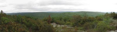
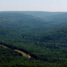
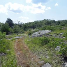
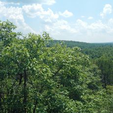
Bell Mountain Wilderness is a protected nature reserve spanning approximately 9,000 acres with oak-hickory forests, granite rock formations, and multiple streams. The terrain sits within Mark Twain National Forest and offers varied landscapes at different elevations.

Congress officially designated this area as a protected Wilderness in 1980, protecting the forest from development. This designation preserved the region's natural resources for future generations.

The name honors an early settler named Henry Bell who lived in the region. Visitors walk through oak and hickory forests that have drawn outdoor enthusiasts for many years and remain an important refuge for people seeking natural surroundings.

The area offers approximately 12 miles of marked hiking trails that wind through varying elevations and landscapes. Conditions range from flatter creek areas to steeper sections with rock formations, so visitors should prepare for different difficulty levels.

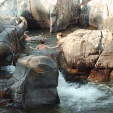
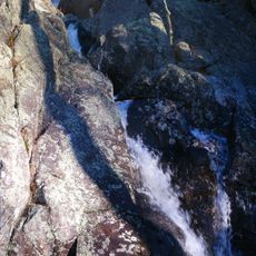
The area contains Shut-In Creek, a year-round stream that has carved deep gorges between steep rock slopes. This constant water source creates conditions for rare habitats and ecosystems that stand out in the otherwise drier mountain region.

Location: Iron County

Inception: 1980

Operator: United States Forest Service

GPS coordinates: 37.63139,-90.87694

Latest update: December 9, 2025 18:43

Photos
Around this place
Taum Sauk Mountain
United States of America

Taum Sauk Mountain

14.8 km
Johnson's Shut-Ins State Park
United States of America

Johnson's Shut-Ins State Park

10.4 km
Elephant Rocks State Park
United States of America

Elephant Rocks State Park

16.8 km
Taum Sauk Mountain State Park
United States of America

Taum Sauk Mountain State Park

14.8 km
St. Joe State Park
United States of America

St. Joe State Park

37.6 km
Missouri Mines State Historic Site
United States of America

Missouri Mines State Historic Site

39.7 km
Dillard Mill State Historic Site
United States of America

Dillard Mill State Historic Site

30.6 km
Fort Davidson
United States of America

Fort Davidson

20.9 km
Arcadia College
United States of America

Arcadia College

22.5 km
Jay Nixon State Park
United States of America

Jay Nixon State Park

9.8 km
Buford Mountain Conservation Area
United States of America

Buford Mountain Conservation Area

17.9 km
Presbyterian Orphanage of Missouri
United States of America

Presbyterian Orphanage of Missouri

43 km
Bootleg Access
United States of America

Bootleg Access

22.8 km
Bonne Terre Depot
United States of America

Bonne Terre Depot

43.1 km
Immanuel Evangelical Lutheran Church
United States of America

Immanuel Evangelical Lutheran Church

20.8 km
St. Paul's Episcopal Church
United States of America

St. Paul's Episcopal Church

22.3 km
Fredericktown Courthouse Square Historic District
United States of America

Fredericktown Courthouse Square Historic District

52.2 km
Madison County Courthouse
United States of America

Madison County Courthouse

52 km
Washington County Courthouse
United States of America

Washington County Courthouse

34.9 km
Iron County Courthouse
United States of America

Iron County Courthouse

22.3 km
St. Francois County Jail and Sheriff's Residence
United States of America

St. Francois County Jail and Sheriff's Residence

43.3 km
Courthouse Square Historic District
United States of America

Courthouse Square Historic District

43.5 km
East Columbia Historic District
United States of America

East Columbia Historic District

43.5 km
James Robinson McCormick House
United States of America

James Robinson McCormick House

43.1 km
Caledonia Historic District
United States of America

Caledonia Historic District

17.4 km
Harrison Queen House
United States of America

Harrison Queen House

17.9 km
United States Post Office
United States of America

United States Post Office

52 km
Ironton Lodge Hall
United States of America

Ironton Lodge Hall

22.1 km
Show the full map
Reviews

Visited this place? Tap the stars to rate it and share your experience / photos with the community! Try now! You can cancel it anytime.

« Bell Mountain Wilderness - Protected wilderness area in Iron County, Missouri » is provided by Around Us (aroundus.com). Images and texts are derived from Wikimedia project under a Creative Commons license. You are allowed to copy, distribute, and modify copies of this page, under the conditions set by the license, as long as this note is clearly visible.

Discover hidden gems everywhere you go!

From secret cafés to breathtaking viewpoints, skip the crowded tourist spots and find places that match your style. Our app makes it easy with voice search, smart filtering, route optimization, and insider tips from travelers worldwide. Download now for the complete mobile experience.

Around Us App Screenshot

A unique approach to discovering new places

Le Figaro

All the places worth exploring

France Info

A tailor-made excursion in just a few clicks

20 Minutes