Enable Location

We need your location to show you interesting places around you

Discover nearby places

Find interesting locations and hidden gems around you

Precise directions

Get accurate directions and distances to places

Your location is never shared with other users. It's only used when you tap the location button.

Taum Sauk Mountain

Log in to your account

Start exploring — it's free

Trusted by 61,344 travelers worldwide

Continue with Google
Continue with Apple
or

We will send you a code to connect

By continuing, you accept our Terms and Conditions and our Privacy Policy

Check your inbox

We've sent a pincode in your inbox. Please enter the code below.

Taum Sauk Mountain

Taum Sauk Mountain, Mountain summit in Iron County, Missouri.

Description

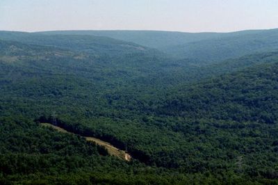
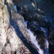
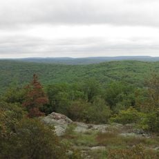
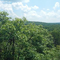
Taum Sauk Mountain is Missouri's highest point, rising above the densely forested hills of the surrounding area. The summit area features rocky formations and open ground that contrast sharply with the thick forest lower down.

History

The name comes from Chief Sauk-Ton-Qua of the Piankeshaw tribe, who inhabited the region before European settlers arrived. The area later transformed as settlement and land use changed the landscape.

Culture

The mountain holds significance in Native American heritage, particularly tied to the Sauk people who lived throughout this region. The landscape itself reflects this historical connection that remains part of local identity.

Practical

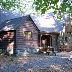
A paved road leads up to the parking area, with just a short walk to the summit marker from there. The path is relatively easy to walk, though sturdy shoes are helpful, especially if conditions are wet or slippery.

Did you know?

During ancient ice ages, this summit stayed above water while surrounding areas were flooded. This isolation made it into its own geological island, creating different habitats from the lower lands.

Location
Elevation above the sea
540 m
GPS coordinates
37.57033,-90.72790
Latest update
December 18, 2025 20:12

AroundUs brings together thousands of curated places, local tips, and hidden gems, enriched daily by 60,000 contributors worldwide. Discover all places nearby (Missouri).

Around this place
Johnson's Shut-Ins State Park
United States of America

Johnson's Shut-Ins State Park

10.5 km
Elephant Rocks State Park
United States of America

Elephant Rocks State Park

10 km
Sam A. Baker State Park
United States of America

Sam A. Baker State Park

39.5 km
Taum Sauk Mountain State Park
United States of America

Taum Sauk Mountain State Park

9 m
Bell Mountain Wilderness
United States of America

Bell Mountain Wilderness

14.8 km
St. Joe State Park
United States of America

St. Joe State Park

32.6 km
Missouri Mines State Historic Site
United States of America

Missouri Mines State Historic Site

35.5 km
Fort Davidson
United States of America

Fort Davidson

10.1 km
Arcadia College
United States of America

Arcadia College

8.8 km
Jay Nixon State Park
United States of America

Jay Nixon State Park

5 km
Buford Mountain Conservation Area
United States of America

Buford Mountain Conservation Area

16.2 km
Presbyterian Orphanage of Missouri
United States of America

Presbyterian Orphanage of Missouri

35.5 km
Bootleg Access
United States of America

Bootleg Access

27.6 km
Bonne Terre Depot
United States of America

Bonne Terre Depot

41.9 km
Immanuel Evangelical Lutheran Church
United States of America

Immanuel Evangelical Lutheran Church

9.8 km
St. Paul's Episcopal Church
United States of America

St. Paul's Episcopal Church

9.5 km
Fredericktown Courthouse Square Historic District
United States of America

Fredericktown Courthouse Square Historic District

38.5 km
Madison County Courthouse
United States of America

Madison County Courthouse

38.3 km
Washington County Courthouse
United States of America

Washington County Courthouse

41.1 km
Iron County Courthouse
United States of America

Iron County Courthouse

9.3 km
St. Francois County Jail and Sheriff's Residence
United States of America

St. Francois County Jail and Sheriff's Residence

35.7 km
Courthouse Square Historic District
United States of America

Courthouse Square Historic District

35.8 km
East Columbia Historic District
United States of America

East Columbia Historic District

35.8 km
James Robinson McCormick House
United States of America

James Robinson McCormick House

35.4 km
Caledonia Historic District
United States of America

Caledonia Historic District

21.8 km
Harrison Queen House
United States of America

Harrison Queen House

24.2 km
United States Post Office
United States of America

United States Post Office

38.3 km
Ironton Lodge Hall
United States of America

Ironton Lodge Hall

9.2 km
Show the full map
« Taum Sauk Mountain - Mountain summit in Iron County, Missouri » is provided by Around Us (aroundus.com). Images and texts are derived from Wikimedia project under a Creative Commons license. You are allowed to copy, distribute, and modify copies of this page, under the conditions set by the license, as long as this note is clearly visible.

Discover hidden gems everywhere you go!

From secret cafés to breathtaking viewpoints, skip the crowded tourist spots and find places that match your style. Our app makes it easy with voice search, smart filtering, route optimization, and insider tips from travelers worldwide. Download now for the complete mobile experience.

Around Us App Screenshot

A unique approach to discovering new places

Le Figaro

All the places worth exploring

France Info

A tailor-made excursion in just a few clicks

20 Minutes

Around Us
Travel Guide & Maps
Download

Send to your phone

QR Code
1

Open the camera app on your mobile.

2

Point at the QR code with your camera. A notification will appear.

3

Tap the notification to open the link.