Enable Location

We need your location to show you interesting places around you

Discover nearby places

Find interesting locations and hidden gems around you

Precise directions

Get accurate directions and distances to places

Your location is never shared with other users. It's only used when you tap the location button.

Grand Tower Pipeline Bridge

Log in to your account

Start exploring — it's free

Trusted by 63,445 travelers worldwide

Continue with Google
Continue with Apple
or

We will send you a code to connect

By continuing, you accept our Terms and Conditions and our Privacy Policy

Check your inbox

We've sent a pincode in your inbox. Please enter the code below.

Grand Tower Pipeline Bridge
Discussion Reviews 1 Photos
2.2k Popularity

Grand Tower Pipeline Bridge, Suspension bridge in Grand Tower, United States.

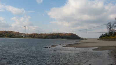
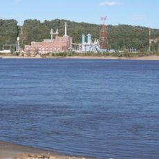
The Grand Tower Pipeline Bridge is a suspension span connecting Illinois and Missouri across the Mississippi River, featuring two steel towers about 266 feet tall. It carries two large pipes side by side for natural gas transport across the river.

This span opened in 1955 as the first pipeline suspension bridge ever built across the Mississippi, designed and constructed by a major New York bridge builder. It emerged during an era when America was rapidly expanding its energy networks after the war.

This structure symbolizes post-war industrial growth in America, linking communities while supporting energy flow between distant regions. It shows how infrastructure connected two states economically and shaped development on both banks.

Access is limited since this is an active industrial structure primarily designed for gas transport rather than public crossing. Visitors can view it from nearby areas, but direct foot or vehicle traffic on the bridge is restricted.

This span is unusual because it carries two large pipes on a single suspension structure, a rare design choice for crossing such a major river. The anchoring system extends far into the riverbed to manage the substantial stresses from carrying pressurized gas continuously.

The community of curious travelers

AroundUs brings together thousands of curated places, local tips, and hidden gems, enriched daily by 60,000 contributors worldwide.

Start exploring
Location
Location
Inception
1955
Official opening
1955
GPS coordinates
37.64190,-89.51750
Latest update
December 13, 2025 12:40
Around this place
Little Grand Canyon
United States of America

Little Grand Canyon

11.6 km
Kinkaid Lake
United States of America

Kinkaid Lake

18.9 km
Tower Rock
United States of America

Tower Rock

1.2 km
Bald Knob Cross
United States of America

Bald Knob Cross

18.1 km
Trail of Tears State Park
United States of America

Trail of Tears State Park

19.9 km
Clear Springs Wilderness
United States of America

Clear Springs Wilderness

11 km
Saxon Lutheran Memorial
United States of America

Saxon Lutheran Memorial

8.6 km
Concordia Lutheran Church
United States of America

Concordia Lutheran Church

9 km
Cleiman Mound and Village Site
United States of America

Cleiman Mound and Village Site

16.2 km
Pomona Natural Bridge
United States of America

Pomona Natural Bridge

15.4 km
St. John Evangelical Lutheran Church
United States of America

St. John Evangelical Lutheran Church

18.9 km
Fountain Bluff
United States of America

Fountain Bluff

4.5 km
Trinity Lutheran Church
United States of America

Trinity Lutheran Church

9 km
Salem Lutheran Church, Farrar, Missouri
United States of America

Salem Lutheran Church, Farrar, Missouri

16.5 km
Immanuel Lutheran Church
United States of America

Immanuel Lutheran Church

8.1 km
Concordia Log Cabin College
United States of America

Concordia Log Cabin College

7.6 km
Grace Lutheran Church
United States of America

Grace Lutheran Church

17.6 km
Red Rock Landing Conservation Area, Perry County, Missouri
United States of America

Red Rock Landing Conservation Area, Perry County, Missouri

18 km
Brazeau Presbyterian Church
United States of America

Brazeau Presbyterian Church

12.1 km
William H. Hull House
United States of America

William H. Hull House

20.7 km
Seventy-Six Conservation Area, Perry County, Missouri
United States of America

Seventy-Six Conservation Area, Perry County, Missouri

12.1 km
Riverside Park Bandshell
United States of America

Riverside Park Bandshell

19 km
Cinque Hommes Creek
United States of America

Cinque Hommes Creek

18.3 km
Brazeau Bottom
United States of America

Brazeau Bottom

4.2 km
Old Appleton Bridge
United States of America

Old Appleton Bridge

17.9 km
Liberty Theater
United States of America

Liberty Theater

20.9 km
Robert W. Hamilton House
United States of America

Robert W. Hamilton House

20.8 km
Eggers and Company General Store
United States of America

Eggers and Company General Store

16.5 km
Show the full map
Reviews
Share your experience

No review yet

Discussions
Start a discussion...

No discussion yet

« Grand Tower Pipeline Bridge - Suspension bridge in Grand Tower, United States » is provided by Around Us (aroundus.com). Images and texts are derived from Wikimedia project under a Creative Commons license. You are allowed to copy, distribute, and modify copies of this page, under the conditions set by the license, as long as this note is clearly visible.

Discover hidden gems everywhere you go!

From secret cafés to breathtaking viewpoints, skip the crowded tourist spots and find places that match your style. Our app makes it easy with voice search, smart filtering, route optimization, and insider tips from travelers worldwide. Download now for the complete mobile experience.

Around Us App Screenshot

A unique approach to discovering new places

Le Figaro

All the places worth exploring

France Info

A tailor-made excursion in just a few clicks

20 Minutes

Around Us
Travel Guide & Maps
Download

Send to your phone

QR Code
1

Open the camera app on your mobile.

2

Point at the QR code with your camera. A notification will appear.

3

Tap the notification to open the link.