Hegman Lake Pictograph

Log in to your account

AroundUs is a community-driven map of interesting places, built by curious explorers like you. It grows with every review, story, and photo you share.
Connect to save your favorite spots, contribute locations, and create personalized routes.
Continue with Google
Continue with Apple
Continue with X
Continue with Facebook
Continue with email
By continuing, you accept our Terms and Conditions and our Privacy Policy
Create an account

Hegman Lake Pictograph

Add to collection
Map
Suggest a change
Share

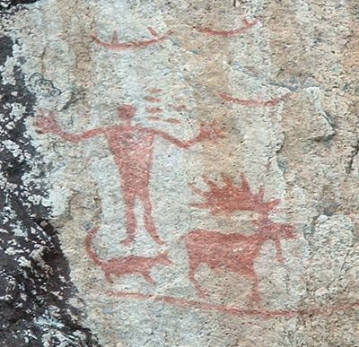
Hegman Lake Pictograph, Ancient rock art in Boundary Waters Canoe Area Wilderness, Minnesota, US.

Hegman Lake Pictograph features red-painted figures on granite rock faces just above the shoreline, depicting humans, moose, canoes, and geometric shapes. The artwork sits within the Boundary Waters and is accessible only by paddling across the lake.

Native Americans created these rock paintings several centuries ago using red pigment derived from iron oxide. The artwork has endured through the generations, marking a long history of indigenous presence in this region.

The central human figure holds meaning in Anishinaabe traditions as a connection to the winter sky and seasonal cycles. Local tribal interpretations help visitors understand how the site relates to broader patterns observed in nature.

Reaching the site requires a canoe journey across the water, with the images visible roughly 2 to 5 feet above the water surface. Visitors should prepare for the remote location and the time needed to paddle out.

The paintings include three separate canoe images complete with paddlers and a human figure with outstretched arms positioned beside what may be an animal. These depictions offer glimpses into both the daily activities and spiritual beliefs of those who painted them.

Location: St. Louis County

GPS coordinates: 48.05444,-91.90333

Latest update: December 11, 2025 18:03

Photos
Around this place
Boundary Waters Canoe Area Wilderness
United States of America

Boundary Waters Canoe Area Wilderness

58.8 km
Lake Vermilion
United States of America

Lake Vermilion

36.8 km
Quetico Provincial Park
Canada

Quetico Provincial Park

46.8 km
Lake Vermilion-Soudan Underground Mine State Park
United States of America

Lake Vermilion-Soudan Underground Mine State Park

35.8 km
Bear Head Lake State Park
United States of America

Bear Head Lake State Park

31.4 km
Finland State Forest
United States of America

Finland State Forest

70.1 km
Kettle Falls Historic District
United States of America

Kettle Falls Historic District

73.9 km
Iron Range Off-Highway Vehicle State Recreation Area
United States of America

Iron Range Off-Highway Vehicle State Recreation Area

68.4 km
Stuntz Bay Boathouse Historic District
United States of America

Stuntz Bay Boathouse Historic District

35.5 km
Alex Seitaniemi Housebarn
United States of America

Alex Seitaniemi Housebarn

42.5 km
Alango School
United States of America

Alango School

73.4 km
Hartley Building
United States of America

Hartley Building

42 km
State Theater
United States of America

State Theater

17.1 km
Longyear Drill Site
United States of America

Longyear Drill Site

57.6 km
Isabella Ranger Station
United States of America

Isabella Ranger Station

56.2 km
Anna and Mikko Pyhala Farm
United States of America

Anna and Mikko Pyhala Farm

48.5 km
William Ingersoll Estate
United States of America

William Ingersoll Estate

53.9 km
Camp Esquagama
United States of America

Camp Esquagama

72.6 km
Erick and Kristina Nelimark Sauna
United States of America

Erick and Kristina Nelimark Sauna

48.8 km
Orr Roadside Parking Area
United States of America

Orr Roadside Parking Area

69 km
Civilian Conservation Corps Camp S-52
United States of America

Civilian Conservation Corps Camp S-52

70.2 km
Waino Tanttari Field Hay Barn
United States of America

Waino Tanttari Field Hay Barn

42.9 km
Dorothy Molter Museum
United States of America

Dorothy Molter Museum

17.7 km
Jasper Peak Fire Tower
United States of America

Jasper Peak Fire Tower

35.5 km
Kekekabic Lookout Tower
United States of America

Kekekabic Lookout Tower

56.4 km
Elephant Lake Lookout Tower
United States of America

Elephant Lake Lookout Tower

64.5 km
Gheen Hill Lookout Tower
United States of America

Gheen Hill Lookout Tower

69.6 km
Vermilion Dam Lookout Tower
United States of America

Vermilion Dam Lookout Tower

43.8 km
Show the full map
Reviews

Visited this place? Tap the stars to rate it and share your experience / photos with the community! Try now! You can cancel it anytime.

« Hegman Lake Pictograph - Ancient rock art in Boundary Waters Canoe Area Wilderness, Minnesota, US » is provided by Around Us (aroundus.com). Images and texts are derived from Wikimedia project under a Creative Commons license. You are allowed to copy, distribute, and modify copies of this page, under the conditions set by the license, as long as this note is clearly visible.

Discover hidden gems everywhere you go!

From secret cafés to breathtaking viewpoints, skip the crowded tourist spots and find places that match your style. Our app makes it easy with voice search, smart filtering, route optimization, and insider tips from travelers worldwide. Download now for the complete mobile experience.

Around Us App Screenshot

A unique approach to discovering new places

Le Figaro

All the places worth exploring

France Info

A tailor-made excursion in just a few clicks

20 Minutes