Enable Location

We need your location to show you interesting places around you

Discover nearby places

Find interesting locations and hidden gems around you

Precise directions

Get accurate directions and distances to places

Your location is never shared with other users. It's only used when you tap the location button.

St. Mary's Covered Bridge

Log in to your account

Start exploring — it's free

Trusted by 62,447 travelers worldwide

Continue with Google
Continue with Apple
or

We will send you a code to connect

By continuing, you accept our Terms and Conditions and our Privacy Policy

Check your inbox

We've sent a pincode in your inbox. Please enter the code below.

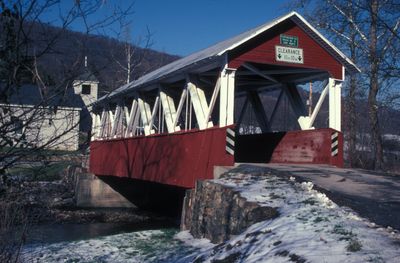
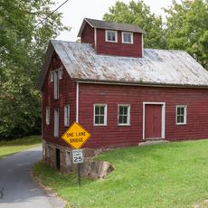
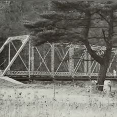
St. Mary's Covered Bridge, place in Pennsylvania listed on National Register of Historic Places

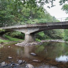
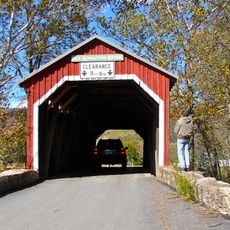
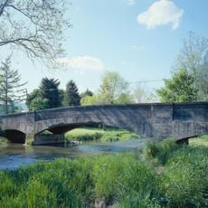
St. Mary's Covered Bridge is a wooden bridge in Huntingdon County, Pennsylvania, that crosses Shade Creek along Route 522. The structure measures about 65 feet long and 17.5 feet wide, featuring a Howe Truss design that uses diagonal wooden supports and vertical metal rods for strength.

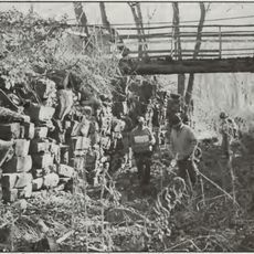
The bridge was built in 1896, though a plaque on the structure dates it to 1889. It is the only remaining covered bridge in Huntingdon County and was reinforced in 1982 with steel I-beams beneath the wooden deck to support modern vehicles while preserving its historical appearance.

The bridge takes its name from St. Mary's Catholic Church across the road, which frames the backdrop of the site. For the local community, it has served as a meeting point and remains a symbol of the craftsmanship and building traditions of the late 1800s.

The bridge is open to vehicle traffic and can be located using GPS coordinates 40.205921, -77.878127. A paved parking area is available nearby, but be aware of the busy adjacent road and mailboxes along the roadside.

This is one of only four remaining Howe Truss covered bridges in Pennsylvania, making it a rare example of this specific construction method from the 1800s. Its distinctive light red color with white trim sets it apart from the darker red appearance of other historic bridges in the region.

The community of curious travelers

AroundUs brings together thousands of curated places, local tips, and hidden gems, enriched daily by 60,000 contributors worldwide.

Start exploring
GPS coordinates
40.20583,-77.87833
Latest update
February 9, 2026 07:40
Around this place
Raystown Lake
United States of America

Raystown Lake

27.6 km
Cowans Gap State Park
United States of America

Cowans Gap State Park

22.9 km
Harbison-Walker Refractories Company
United States of America

Harbison-Walker Refractories Company

20.1 km
Trough Creek State Park
United States of America

Trough Creek State Park

25.5 km
Rockhill Trolley Museum
United States of America

Rockhill Trolley Museum

4.3 km
Fowlers Hollow State Park
United States of America

Fowlers Hollow State Park

26.4 km
Butler Knob
United States of America

Butler Knob

12.3 km
Baker Bridge
United States of America

Baker Bridge

22.5 km
Woodvale Historic District
United States of America

Woodvale Historic District

22.5 km
New Germantown Covered Bridge
United States of America

New Germantown Covered Bridge

28.6 km
Carrick Furnace
United States of America

Carrick Furnace

20.8 km
Runk Bridge
United States of America

Runk Bridge

8 km
Horse Valley Bridge
United States of America

Horse Valley Bridge

18.6 km
Mt. Pleasant Iron Works House
United States of America

Mt. Pleasant Iron Works House

26.9 km
Benjamin B. Leas House
United States of America

Benjamin B. Leas House

10.4 km
Burnt Cabins Gristmill Property
United States of America

Burnt Cabins Gristmill Property

14.4 km
Paradise Furnace
United States of America

Paradise Furnace

24.1 km
Bridge in Metal Township
United States of America

Bridge in Metal Township

12.8 km
Franklin Furnace Historic District
United States of America

Franklin Furnace Historic District

27.9 km
Robertsdale Historic District
United States of America

Robertsdale Historic District

20.1 km
Hudson Grist Mill
United States of America

Hudson Grist Mill

11 km
Lewis Smalley Homestead
United States of America

Lewis Smalley Homestead

17.7 km
Pennsylvania Canal Guard Lock and Feeder Dam, Raystown Branch
United States of America

Pennsylvania Canal Guard Lock and Feeder Dam, Raystown Branch

26 km
McConnellsburg Historic District
United States of America

McConnellsburg Historic District

22.5 km
Frehn Bridge
United States of America

Frehn Bridge

12.6 km
Big Spring State Forest Picnic Area
United States of America

Big Spring State Forest Picnic Area

20.4 km
Swigart Museum
United States of America

Swigart Museum

27.2 km
McClay's Twin Bridge
United States of America

McClay's Twin Bridge

28.8 km
Show the full map
« St. Mary's Covered Bridge - place in Pennsylvania listed on National Register of Historic Places » is provided by Around Us (aroundus.com). Images and texts are derived from Wikimedia project under a Creative Commons license. You are allowed to copy, distribute, and modify copies of this page, under the conditions set by the license, as long as this note is clearly visible.

Discover hidden gems everywhere you go!

From secret cafés to breathtaking viewpoints, skip the crowded tourist spots and find places that match your style. Our app makes it easy with voice search, smart filtering, route optimization, and insider tips from travelers worldwide. Download now for the complete mobile experience.

Around Us App Screenshot

A unique approach to discovering new places

Le Figaro

All the places worth exploring

France Info

A tailor-made excursion in just a few clicks

20 Minutes

Around Us
Travel Guide & Maps
Download

Send to your phone

QR Code
1

Open the camera app on your mobile.

2

Point at the QR code with your camera. A notification will appear.

3

Tap the notification to open the link.