Enable Location

We need your location to show you interesting places around you

Discover nearby places

Find interesting locations and hidden gems around you

Precise directions

Get accurate directions and distances to places

Your location is never shared with other users. It's only used when you tap the location button.

Log in to your account

Start exploring — it's free

Trusted by 63,780 travelers worldwide

Continue with Google
Continue with Apple
or

We will send you a code to connect

By continuing, you accept our Terms and Conditions and our Privacy Policy

Check your inbox

We've sent a pincode in your inbox. Please enter the code below.

Louisiana Highway 1 Bridge
Discussion Reviews Photo
6.8k Popularity

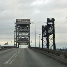
Louisiana Highway 1 Bridge, Toll bridge in Lafourche Parish, Louisiana, US.

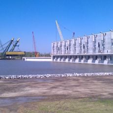
The Louisiana Highway 1 Bridge is a toll bridge that crosses over Bayou Lafourche and surrounding marshland to connect Leeville with the Port Fourchon industrial terminal. The structure uses concrete trestle construction designed to withstand the harsh coastal environment.

The bridge was completed in 2009 as part of a major infrastructure project to improve transportation in coastal Louisiana. The project was driven by growing industrial demands at the port facility.

This concrete trestle bridge acts as a vital connector for local communities, industrial facilities, and fisheries along the Louisiana coastline.

Vehicles pay tolls based on axle count, with cars typically paying between 3.75 and 5 dollars per trip. The best times to cross are outside peak hours to avoid morning and evening work commutes.

The bridge serves as the primary evacuation route for residents and industrial workers during hurricanes and tropical storms. This critical role shapes its infrastructure planning and maintenance priorities.

The community of curious travelers

AroundUs brings together thousands of curated places, local tips, and hidden gems, enriched daily by 60,000 contributors worldwide.

Start exploring
Inception
2009
Official opening
2009
GPS coordinates
29.22612,-90.19496
Latest update
December 9, 2025 18:42
Around this place
Fort Jackson
United States of America

Fort Jackson

73.3 km
Fort St. Philip
United States of America

Fort St. Philip

72.7 km
Fort Livingston
United States of America

Fort Livingston

24.8 km
Grand Isle State Park
United States of America

Grand Isle State Park

23.6 km
Gulf Intracoastal Waterway West Closure Complex
United States of America

Gulf Intracoastal Waterway West Closure Complex

66.8 km
Mary Plantation House
United States of America

Mary Plantation House

67.1 km
Cathedral of St. Francis de Sales
United States of America

Cathedral of St. Francis de Sales

65.6 km
Mandalay National Wildlife Refuge
United States of America

Mandalay National Wildlife Refuge

67.8 km
Harlem Plantation House
United States of America

Harlem Plantation House

52.6 km
Bayou Grande Cheniere Mounds
United States of America

Bayou Grande Cheniere Mounds

49.3 km
Orange Grove Plantation House
United States of America

Orange Grove Plantation House

73.1 km
Judge Perez Bridge
United States of America

Judge Perez Bridge

74.1 km
Residence Plantation House
United States of America

Residence Plantation House

63.3 km
Promised Land
United States of America

Promised Land

66 km
St. Matthew's Episcopal Church
United States of America

St. Matthew's Episcopal Church

65.4 km
Bouverans Plantation House
United States of America

Bouverans Plantation House

54.4 km
St. Patrick's Catholic Church
United States of America

St. Patrick's Catholic Church

60.7 km
Argyle
United States of America

Argyle

66.3 km
Clifford Percival Smith House
United States of America

Clifford Percival Smith House

65.7 km
Merchants and Planters Bank
United States of America

Merchants and Planters Bank

57.5 km
Bank of Lockport
United States of America

Bank of Lockport

57.4 km
Bayou Terrebonne Waterlife Museum
United States of America

Bayou Terrebonne Waterlife Museum

65.7 km
Manila Village
United States of America

Manila Village

57 km
Chauvin Sculpture Garden & Art
United States of America

Chauvin Sculpture Garden & Art

45.6 km
Park Theatre
United States of America

Park Theatre

65.7 km
Barataria Preserve
United States of America

Barataria Preserve

64.1 km
Barataria Unit of Jean Lafitte Historical Park Historic District
United States of America

Barataria Unit of Jean Lafitte Historical Park Historic District

64.1 km
Wesley House
United States of America

Wesley House

64.8 km
Show the full map
Reviews
Share your experience

No review yet

Discussions
Start a discussion...

No discussion yet

« Louisiana Highway 1 Bridge - Toll bridge in Lafourche Parish, Louisiana, US » is provided by Around Us (aroundus.com). Images and texts are derived from Wikimedia project under a Creative Commons license. You are allowed to copy, distribute, and modify copies of this page, under the conditions set by the license, as long as this note is clearly visible.

Discover hidden gems everywhere you go!

From secret cafés to breathtaking viewpoints, skip the crowded tourist spots and find places that match your style. Our app makes it easy with voice search, smart filtering, route optimization, and insider tips from travelers worldwide. Download now for the complete mobile experience.

Around Us App Screenshot

A unique approach to discovering new places

Le Figaro

All the places worth exploring

France Info

A tailor-made excursion in just a few clicks

20 Minutes

Around Us
Travel Guide & Maps
Download

Send to your phone

QR Code
1

Open the camera app on your mobile.

2

Point at the QR code with your camera. A notification will appear.

3

Tap the notification to open the link.