Enable Location

We need your location to show you interesting places around you

Discover nearby places

Find interesting locations and hidden gems around you

Precise directions

Get accurate directions and distances to places

Your location is never shared with other users. It's only used when you tap the location button.

Bayou Grande Cheniere Mounds

Log in to your account

Start exploring — it's free

Trusted by 63,421 travelers worldwide

Continue with Google
Continue with Apple
or

We will send you a code to connect

By continuing, you accept our Terms and Conditions and our Privacy Policy

Check your inbox

We've sent a pincode in your inbox. Please enter the code below.

Bayou Grande Cheniere Mounds
Discussion Reviews 1 Photos
1.7k Popularity

Bayou Grande Cheniere Mounds, Archaeological site in Plaquemines Parish, Louisiana, United States.

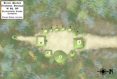
Bayou Grande Cheniere Mounds is an archaeological site consisting of twelve earthen mounds positioned around a central plaza. The tallest mound rises approximately 60 feet (18 meters) on the eastern side of the plaza and forms the most prominent structure at the location.

The site was occupied from 875 to 1200 CE during the Coastal Coles Creek period, representing a substantial timespan of habitation. Scientific investigations began in 1926 when the Smithsonian Institution conducted the initial excavations.

The mounds were arranged to create a gathering space where people came together for ceremonies and communal activities. This layout reveals how the community organized itself around shared rituals and events.

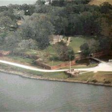
The site is best explored on foot to appreciate the scale and arrangement of the mounds from different vantage points. Wear sturdy footwear since the terrain is uneven and can become muddy, especially after rainfall.

A constructed causeway once linked the settlement to nearby Bayou Grande Cheniere, demonstrating that residents had sophisticated knowledge of water management. This connection shows that water transport played a central role in their daily life and trade routes.

The community of curious travelers

AroundUs brings together thousands of curated places, local tips, and hidden gems, enriched daily by 60,000 contributors worldwide.

Start exploring
Location
GPS coordinates
29.49630,-89.79260
Latest update
December 14, 2025 13:04
Around this place
Fort Jackson
United States of America

Fort Jackson

36.2 km
Mississippi River – Gulf Outlet Canal
United States of America

Mississippi River – Gulf Outlet Canal

44.1 km
17th Ward of New Orleans
United States of America

17th Ward of New Orleans

52.3 km
Fort St. Philip
United States of America

Fort St. Philip

35.2 km
Fort Proctor
United States of America

Fort Proctor

42.8 km
Jackson Barracks
United States of America

Jackson Barracks

54.9 km
Fort Livingston
United States of America

Fort Livingston

28.9 km
12th Ward of New Orleans
United States of America

12th Ward of New Orleans

52.8 km
Grand Isle State Park
United States of America

Grand Isle State Park

30.8 km
Gulf Intracoastal Waterway West Closure Complex
United States of America

Gulf Intracoastal Waterway West Closure Complex

44.4 km
Kenilworth Plantation House
United States of America

Kenilworth Plantation House

41.3 km
LeBeau Plantation
United States of America

LeBeau Plantation

54.4 km
St. Bernard State Park
United States of America

St. Bernard State Park

42 km
Mary Plantation House
United States of America

Mary Plantation House

39.7 km
Behrman Stadium
United States of America

Behrman Stadium

54.8 km
Harlem Plantation House
United States of America

Harlem Plantation House

17.8 km
Judge Perez Bridge
United States of America

Judge Perez Bridge

46.8 km
Promised Land
United States of America

Promised Land

39.1 km
Gretna Historic District
United States of America

Gretna Historic District

53.5 km
Old Jefferson Parish Courthouse
United States of America

Old Jefferson Parish Courthouse

53.7 km
Kerner House
United States of America

Kerner House

54.2 km
St. Patrick's Catholic Church
United States of America

St. Patrick's Catholic Church

16.9 km
Friscoville Street Historic District
United States of America

Friscoville Street Historic District

54.4 km
Los Isleños Museum Complex
United States of America

Los Isleños Museum Complex

42.1 km
Chalmette Unit of Jean Lafitte National Historical Park
United States of America

Chalmette Unit of Jean Lafitte National Historical Park

53.4 km
Sebastopol Plantation
United States of America

Sebastopol Plantation

42.1 km
Manila Village
United States of America

Manila Village

41.8 km
Barataria Preserve
United States of America

Barataria Preserve

46.5 km
Show the full map
Reviews
Share your experience

No review yet

Discussions
Start a discussion...

No discussion yet

« Bayou Grande Cheniere Mounds - Archaeological site in Plaquemines Parish, Louisiana, United States » is provided by Around Us (aroundus.com). Images and texts are derived from Wikimedia project under a Creative Commons license. You are allowed to copy, distribute, and modify copies of this page, under the conditions set by the license, as long as this note is clearly visible.

Discover hidden gems everywhere you go!

From secret cafés to breathtaking viewpoints, skip the crowded tourist spots and find places that match your style. Our app makes it easy with voice search, smart filtering, route optimization, and insider tips from travelers worldwide. Download now for the complete mobile experience.

Around Us App Screenshot

A unique approach to discovering new places

Le Figaro

All the places worth exploring

France Info

A tailor-made excursion in just a few clicks

20 Minutes

Around Us
Travel Guide & Maps
Download

Send to your phone

QR Code
1

Open the camera app on your mobile.

2

Point at the QR code with your camera. A notification will appear.

3

Tap the notification to open the link.