Mississippi River – Gulf Outlet Canal

Log in to your account

AroundUs is a community-driven map of interesting places, built by curious explorers like you. It grows with every review, story, and photo you share.
Connect to save your favorite spots, contribute locations, and create personalized routes.
By continuing, you accept our Terms and Conditions and our Privacy Policy

Mississippi River – Gulf Outlet Canal

Add to collection
Map
Suggest a change
Share

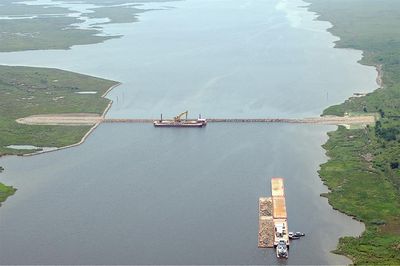
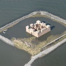
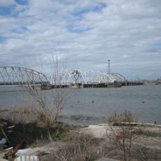
Mississippi River – Gulf Outlet Canal, Navigation canal in Louisiana, United States.

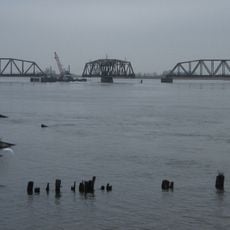
The Mississippi River-Gulf Outlet Canal is a navigation channel running about 76 miles from the Gulf of Mexico to New Orleans' inner harbor. The waterway cuts through marshland and widens significantly in sections where water movement shaped the banks over time.

The United States Congress approved construction in 1956, and the Army Corps of Engineers completed the channel in 1968. The project was designed to provide faster access to the harbor for ocean-going vessels and boost commerce for the region.

The canal reflects how maritime trade shaped Louisiana's development and the Port of New Orleans' need for faster shipping routes. It remains visible evidence of the region's commitment to efficient commerce and transportation.

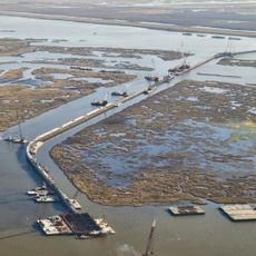
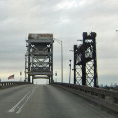
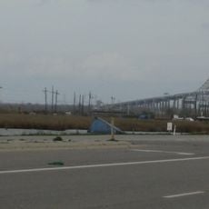
A surge barrier built in 2009 now blocks maritime traffic through the canal, making direct shipping access impossible. The surrounding marshlands remain accessible by boat or from nearby viewpoints on land.

By 2005, the canal had widened to four times its original width due to natural erosion of surrounding marshlands. This dramatic expansion reveals the powerful force of water and tidal movement reshaping the landscape over decades.

Location: Louisiana

GPS coordinates: 29.89126,-89.75744

Latest update: December 7, 2025 20:44

Photos
Around this place
Show the full map
Six Flags New Orleans
United States of America

Six Flags New Orleans

24.7 km
Fort Macomb
United States of America

Fort Macomb

19.8 km
IHNC Lake Borgne Surge Barrier
United States of America

IHNC Lake Borgne Surge Barrier

18.8 km
The Jester
United States of America

The Jester

25.1 km
Fort Proctor
United States of America

Fort Proctor

8.1 km
Jackson Barracks
United States of America

Jackson Barracks

25.3 km
Mega Zeph
United States of America

Mega Zeph

25 km
Zydeco Scream
United States of America

Zydeco Scream

24.7 km
Muskrat Scrambler
United States of America

Muskrat Scrambler

24.8 km
Kenilworth Plantation House
United States of America

Kenilworth Plantation House

6.1 km
LeBeau Plantation
United States of America

LeBeau Plantation

24.7 km
St. Bernard State Park
United States of America

St. Bernard State Park

14.2 km
Mary Plantation House
United States of America

Mary Plantation House

25.3 km
Behrman Stadium
United States of America

Behrman Stadium

26.9 km
Chef Menteur Bridge
United States of America

Chef Menteur Bridge

20.2 km
Judge Perez Bridge
United States of America

Judge Perez Bridge

24.4 km
Bayou Sauvage National Wildlife Refuge
United States of America

Bayou Sauvage National Wildlife Refuge

23.2 km
Promised Land
United States of America

Promised Land

26.1 km
CSX Chef Menteur Pass Bridge
United States of America

CSX Chef Menteur Pass Bridge

19.7 km
Green Bridge
United States of America

Green Bridge

21.6 km
Friscoville Street Historic District
United States of America

Friscoville Street Historic District

24.4 km
Lower Ninth Ward Living Museum
United States of America

Lower Ninth Ward Living Museum

25.8 km
Los Isleños Museum Complex
United States of America

Los Isleños Museum Complex

10.1 km
Chalmette Unit of Jean Lafitte National Historical Park
United States of America

Chalmette Unit of Jean Lafitte National Historical Park

23.5 km
Versailles Arms
United States of America

Versailles Arms

22.3 km
House of Dance & Feathers
United States of America

House of Dance & Feathers

25.6 km
Sebastopol Plantation
United States of America

Sebastopol Plantation

11.4 km
Thánh đường Các thánh tử đạo Việt Nam
United States of America

Thánh đường Các thánh tử đạo Việt Nam

22.2 km
Show the full map
Reviews

Visited this place? Tap the stars to rate it and share your experience / photos with the community! Try now! You can cancel it anytime.

« Mississippi River – Gulf Outlet Canal - Navigation canal in Louisiana, United States » is provided by Around Us (aroundus.com). Images and texts are derived from Wikimedia project under a Creative Commons license. You are allowed to copy, distribute, and modify copies of this page, under the conditions set by the license, as long as this note is clearly visible.

Discover hidden gems everywhere you go!

From secret cafés to breathtaking viewpoints, skip the crowded tourist spots and find places that match your style. Our app makes it easy with voice search, smart filtering, route optimization, and insider tips from travelers worldwide. Download now for the complete mobile experience.

Around Us App Screenshot

A unique approach to discovering new places

Le Figaro

All the places worth exploring

France Info

A tailor-made excursion in just a few clicks

20 Minutes