Enable Location

We need your location to show you interesting places around you

Discover nearby places

Find interesting locations and hidden gems around you

Precise directions

Get accurate directions and distances to places

Your location is never shared with other users. It's only used when you tap the location button.

IHNC Lake Borgne Surge Barrier

Log in to your account

Start exploring — it's free

Trusted by 61,352 travelers worldwide

Continue with Google
Continue with Apple
or

We will send you a code to connect

By continuing, you accept our Terms and Conditions and our Privacy Policy

Check your inbox

We've sent a pincode in your inbox. Please enter the code below.

IHNC Lake Borgne Surge Barrier

IHNC Lake Borgne Surge Barrier, Flood barrier in New Orleans, United States

Description

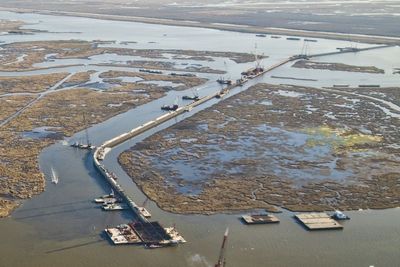
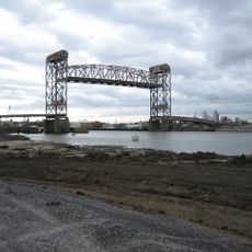
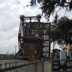
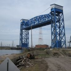
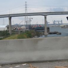
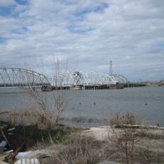
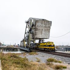
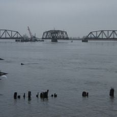
The IHNC Lake Borgne Surge Barrier is a large flood control structure spanning the Gulf Intracoastal Waterway and Mississippi River Gulf Outlet near New Orleans. It uses a wide sector gate and a vertical lift gate to allow ships to pass through while blocking dangerous surge from storms.

History

After Hurricane Katrina struck in 2005, the U.S. Army Corps of Engineers built this barrier as part of a broader system to defend against hurricanes and storm damage. The project represented a major shift in how the region prepared for future disasters.

Culture

Locals call this the Great Wall of Louisiana, reflecting how deeply the structure has become part of the community's identity and its determination to safeguard against water. The nickname shows how the barrier represents more than just engineering—it embodies resilience and protection.

Practical

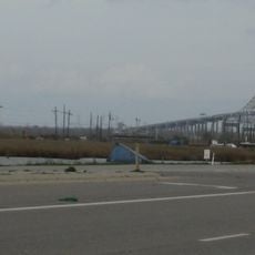
The barrier can be seen from nearby roads and observation areas along the waterways surrounding it. Keep in mind that this is an active flood control facility, so access to certain areas may be limited for safety reasons.

Did you know?

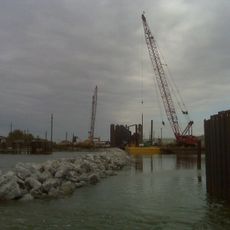
The structure rests on more than a thousand massive concrete pilings driven deep into the seabed, giving it exceptional stability. This engineering solution makes it one of the most robust flood barriers of its kind in North America.

Location
GPS coordinates
30.00560,-89.90140
Latest update
December 7, 2025 19:24

AroundUs brings together thousands of curated places, local tips, and hidden gems, enriched daily by 60,000 contributors worldwide. Discover all places nearby (Louisiana).

Around this place
Six Flags New Orleans
United States of America

Six Flags New Orleans

6 km
William Frantz Elementary School
United States of America

William Frantz Elementary School

13.2 km
Fort Macomb
United States of America

Fort Macomb

11.4 km
Industrial Canal
United States of America

Industrial Canal

12.3 km
The Jester
United States of America

The Jester

6.4 km
Jackson Barracks
United States of America

Jackson Barracks

12.1 km
Mega Zeph
United States of America

Mega Zeph

6.3 km
Danziger Bridge
United States of America

Danziger Bridge

12.1 km
Zydeco Scream
United States of America

Zydeco Scream

6 km
Claiborne Avenue Bridge
United States of America

Claiborne Avenue Bridge

12.7 km
I-10 High Rise Bridge
United States of America

I-10 High Rise Bridge

12 km
Seabrook Floodgate
United States of America

Seabrook Floodgate

13.1 km
Muskrat Scrambler
United States of America

Muskrat Scrambler

6.1 km
LeBeau Plantation
United States of America

LeBeau Plantation

11.8 km
St. Claude Avenue Bridge
United States of America

St. Claude Avenue Bridge

13 km
McDonogh 19 Elementary School
United States of America

McDonogh 19 Elementary School

11.9 km
Florida Avenue Bridge
United States of America

Florida Avenue Bridge

11.9 km
Almonaster Avenue Bridge
United States of America

Almonaster Avenue Bridge

12 km
Chef Menteur Bridge
United States of America

Chef Menteur Bridge

11.7 km
Seabrook Railroad Bridge
United States of America

Seabrook Railroad Bridge

13.1 km
Bayou Sauvage National Wildlife Refuge
United States of America

Bayou Sauvage National Wildlife Refuge

9.7 km
CSX Chef Menteur Pass Bridge
United States of America

CSX Chef Menteur Pass Bridge

11.7 km
Green Bridge
United States of America

Green Bridge

3.6 km
Friscoville Street Historic District
United States of America

Friscoville Street Historic District

11.4 km
Lower Ninth Ward Living Museum
United States of America

Lower Ninth Ward Living Museum

11.8 km
Chalmette Unit of Jean Lafitte National Historical Park
United States of America

Chalmette Unit of Jean Lafitte National Historical Park

11.4 km
Versailles Arms
United States of America

Versailles Arms

4.1 km
House of Dance & Feathers
United States of America

House of Dance & Feathers

11.5 km
Show the full map
« IHNC Lake Borgne Surge Barrier - Flood barrier in New Orleans, United States » is provided by Around Us (aroundus.com). Images and texts are derived from Wikimedia project under a Creative Commons license. You are allowed to copy, distribute, and modify copies of this page, under the conditions set by the license, as long as this note is clearly visible.

Discover hidden gems everywhere you go!

From secret cafés to breathtaking viewpoints, skip the crowded tourist spots and find places that match your style. Our app makes it easy with voice search, smart filtering, route optimization, and insider tips from travelers worldwide. Download now for the complete mobile experience.

Around Us App Screenshot

A unique approach to discovering new places

Le Figaro

All the places worth exploring

France Info

A tailor-made excursion in just a few clicks

20 Minutes

Around Us
Travel Guide & Maps
Download

Send to your phone

QR Code
1

Open the camera app on your mobile.

2

Point at the QR code with your camera. A notification will appear.

3

Tap the notification to open the link.