Enable Location

We need your location to show you interesting places around you

Discover nearby places

Find interesting locations and hidden gems around you

Precise directions

Get accurate directions and distances to places

Your location is never shared with other users. It's only used when you tap the location button.

Seabrook Floodgate

Log in to your account

Start exploring — it's free

Trusted by 65,242 travelers worldwide

Continue with Google
Continue with Apple
or

We will send you a code to connect

By continuing, you accept our Terms and Conditions and our Privacy Policy

Check your inbox

We've sent a pincode in your inbox. Please enter the code below.

Seabrook Floodgate
Discussion Reviews 1 Photos
3.4k Popularity

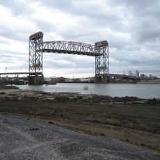
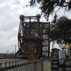
Seabrook Floodgate, Flood barrier near Industrial Canal, New Orleans, Louisiana.

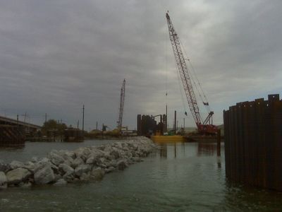
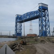
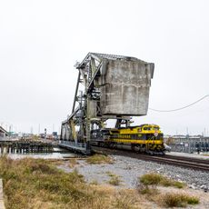
The Seabrook Floodgate is a flood barrier at the northern end of the Industrial Canal in New Orleans, Louisiana, where the canal meets Lake Pontchartrain. It consists of two large sector gate leaves and a vertical lift gate that together can fully close the canal opening.

The structure was built in response to Hurricane Katrina in 2005, which flooded much of the city and exposed the limits of the existing flood defense network. It became one of the central projects in a broad program to rebuild and strengthen protections across the region.

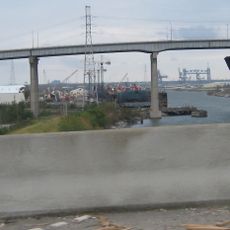
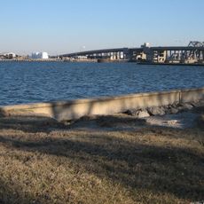
The name Seabrook comes from the nearby bridge that crosses the same waterway at this point. Standing at the gate, you can clearly see how the city sits between the lake and its network of canals, with water on nearly every side.

The floodgate is visible from the bank of the Industrial Canal and can be viewed without any entrance fee. It is best to visit outside of storm warning periods, as the gates may be in operation during bad weather and access can be limited.

Although the gates stay open most of the time to allow boat traffic and water exchange, they can be fully closed within a matter of hours once a storm is forecast. The sector gate leaves swing inward on a curved path rather than sliding straight down, which makes the closing motion look more like a door than a dam.

The community of curious travelers

AroundUs brings together thousands of curated places, local tips, and hidden gems, enriched daily by 60,000 contributors worldwide.

Start exploring
Location
GPS coordinates
30.03170,-90.03440
Latest update
March 3, 2026 13:59
Around this place
Frenchmen Street
United States of America

Frenchmen Street

4.7 km
United States of America

7th Ward of New Orleans

5.9 km
City Park
United States of America

City Park

6.5 km
United States of America

Pontchartrain Beach

2.7 km
Industrial Canal
United States of America

Industrial Canal

2.2 km
New Orleans Museum of Art
United States of America

New Orleans Museum of Art

7.6 km
Gen. Beauregard Equestrian Statue
United States of America

Gen. Beauregard Equestrian Statue

7.5 km
Danziger Bridge
United States of America

Danziger Bridge

2.7 km
Pan American Stadium
United States of America

Pan American Stadium

6.6 km
Claiborne Avenue Bridge
United States of America

Claiborne Avenue Bridge

7 km
Spanish Fort
United States of America

Spanish Fort

4.8 km
I-10 High Rise Bridge
United States of America

I-10 High Rise Bridge

3.1 km
St. Roch Market
United States of America

St. Roch Market

7.1 km
St. Claude Avenue Bridge
United States of America

St. Claude Avenue Bridge

7.6 km
New Canal Light
United States of America

New Canal Light

7.6 km
Florida Avenue Bridge
United States of America

Florida Avenue Bridge

5.8 km
Almonaster Avenue Bridge
United States of America

Almonaster Avenue Bridge

3.1 km
Seabrook Bridge
United States of America

Seabrook Bridge

15 m
St. Vincent De Paul Roman Catholic Church
United States of America

St. Vincent De Paul Roman Catholic Church

7.6 km
St. Frances Cabrini Church
United States of America

St. Frances Cabrini Church

4.4 km
Seabrook Railroad Bridge
United States of America

Seabrook Railroad Bridge

38 m
Degas House, New Orleans
United States of America

Degas House, New Orleans

7.5 km
The Singing Oak
United States of America

The Singing Oak

7.4 km
New Canal Lighthouse
United States of America

New Canal Lighthouse

7.6 km
Free People of Color Museum
United States of America

Free People of Color Museum

7.6 km
Milneberg Lighthouse
United States of America

Milneberg Lighthouse

2.7 km
Lakeshore Drive Bayou St. John Bridge
United States of America

Lakeshore Drive Bayou St. John Bridge

4.7 km
Saint Roch Chapel
United States of America

Saint Roch Chapel

6.5 km
Show the full map
Reviews
Share your experience

No review yet

Discussions
Start a discussion...

No discussion yet

« Seabrook Floodgate - Flood barrier near Industrial Canal, New Orleans, Louisiana » is provided by Around Us (aroundus.com). Images and texts are derived from Wikimedia project under a Creative Commons license. You are allowed to copy, distribute, and modify copies of this page, under the conditions set by the license, as long as this note is clearly visible.

Discover hidden gems everywhere you go!

From secret cafés to breathtaking viewpoints, skip the crowded tourist spots and find places that match your style. Our app makes it easy with voice search, smart filtering, route optimization, and insider tips from travelers worldwide. Download now for the complete mobile experience.

Around Us App Screenshot

A unique approach to discovering new places

Le Figaro

All the places worth exploring

France Info

A tailor-made excursion in just a few clicks

20 Minutes

Around Us
Travel Guide & Maps
Download

Send to your phone

QR Code
1

Open the camera app on your mobile.

2

Point at the QR code with your camera. A notification will appear.

3

Tap the notification to open the link.