Enable Location

We need your location to show you interesting places around you

Discover nearby places

Find interesting locations and hidden gems around you

Precise directions

Get accurate directions and distances to places

Your location is never shared with other users. It's only used when you tap the location button.

Danziger Bridge

Log in to your account

Start exploring — it's free

Trusted by 61,361 travelers worldwide

Continue with Google
Continue with Apple
or

We will send you a code to connect

By continuing, you accept our Terms and Conditions and our Privacy Policy

Check your inbox

We've sent a pincode in your inbox. Please enter the code below.

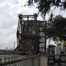
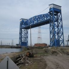
Danziger Bridge, Vertical-lift road bridge in New Orleans, United States

Description

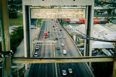
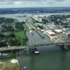
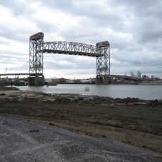
The Danziger Bridge carries US Route 90 across the Industrial Canal with seven lanes of traffic through eastern New Orleans. Its vertical-lift design allows the deck to raise and lower, creating an opening for boats to pass beneath.

History

A new vertical-lift bridge opened in February 1988, replacing an earlier drawbridge from 1932 that had become outdated for the area's needs. This replacement represented a major upgrade in the city's transportation infrastructure.

Culture

The bridge bears the name of Alfred Danziger, a lawyer who worked as executive counsel for Mayor Robert Maestri from 1936 to 1946. Today, the name marks this key transportation route through the eastern part of the city.

Practical

The bridge carries heavy daily traffic, especially during peak hours when thousands of vehicles cross between Chef Menteur Highway and surrounding neighborhoods. Pedestrians and cyclists should note that this is primarily a vehicle corridor.

Did you know?

When it opened in 1988, this was the widest vertical-lift bridge in the world, showcasing engineering achievement of that era. This remarkable width made it possible to carry seven lanes simultaneously across the canal.

Location
Official opening
February 1988
Length
996.43 m
GPS coordinates
30.00830,-90.02720
Latest update
December 9, 2025 18:40

AroundUs brings together thousands of curated places, local tips, and hidden gems, enriched daily by 60,000 contributors worldwide. Discover all places nearby (New Orleans).

Around this place
Dillard University
United States of America

Dillard University

4 km
Frenchmen Street
United States of America

Frenchmen Street

3.5 km
United States of America

7th Ward of New Orleans

4.8 km
New Orleans Mint
United States of America

New Orleans Mint

6 km
William Frantz Elementary School
United States of America

William Frantz Elementary School

3.6 km
Industrial Canal
United States of America

Industrial Canal

462 m
Claiborne Avenue Bridge
United States of America

Claiborne Avenue Bridge

4.4 km
Spanish Fort
United States of America

Spanish Fort

5.6 km
I-10 High Rise Bridge
United States of America

I-10 High Rise Bridge

409 m
St. Roch Market
United States of America

St. Roch Market

5 km
St. Claude Avenue Bridge
United States of America

St. Claude Avenue Bridge

4.9 km
McDonogh 19 Elementary School
United States of America

McDonogh 19 Elementary School

5.5 km
Florida Avenue Bridge
United States of America

Florida Avenue Bridge

3.1 km
Almonaster Avenue Bridge
United States of America

Almonaster Avenue Bridge

441 m
Seabrook Bridge
United States of America

Seabrook Bridge

2.7 km
St. Vincent De Paul Roman Catholic Church
United States of America

St. Vincent De Paul Roman Catholic Church

5.2 km
St. Frances Cabrini Church
United States of America

St. Frances Cabrini Church

4.7 km
U.S. Army Supply Base New Orleans
United States of America

U.S. Army Supply Base New Orleans

5.2 km
Seabrook Railroad Bridge
United States of America

Seabrook Railroad Bridge

2.7 km
Jamnola
United States of America

Jamnola

5.4 km
Lombard Plantation
United States of America

Lombard Plantation

5.4 km
StudioBE
United States of America

StudioBE

5.3 km
Degas House, New Orleans
United States of America

Degas House, New Orleans

6 km
Lower Ninth Ward Living Museum
United States of America

Lower Ninth Ward Living Museum

5.5 km
Free People of Color Museum
United States of America

Free People of Color Museum

6 km
House of Dance & Feathers
United States of America

House of Dance & Feathers

5.4 km
Milneberg Lighthouse
United States of America

Milneberg Lighthouse

4.3 km
Lakeshore Drive Bayou St. John Bridge
United States of America

Lakeshore Drive Bayou St. John Bridge

5.7 km
Show the full map
« Danziger Bridge - Vertical-lift road bridge in New Orleans, United States » is provided by Around Us (aroundus.com). Images and texts are derived from Wikimedia project under a Creative Commons license. You are allowed to copy, distribute, and modify copies of this page, under the conditions set by the license, as long as this note is clearly visible.

Discover hidden gems everywhere you go!

From secret cafés to breathtaking viewpoints, skip the crowded tourist spots and find places that match your style. Our app makes it easy with voice search, smart filtering, route optimization, and insider tips from travelers worldwide. Download now for the complete mobile experience.

Around Us App Screenshot

A unique approach to discovering new places

Le Figaro

All the places worth exploring

France Info

A tailor-made excursion in just a few clicks

20 Minutes

Around Us
Travel Guide & Maps
Download

Send to your phone

QR Code
1

Open the camera app on your mobile.

2

Point at the QR code with your camera. A notification will appear.

3

Tap the notification to open the link.