Chest opened
+${chestReward.xp} XP
Explorer
NOUVEAU ×${chestReward.collectible.quantity}
tapez pour fermer
Chest locked

Open chests in the app

Around Us is built for your phone — chests unlock when you walk, explore and capture nearby places.

Enable Location

We need your location to show you interesting places around you

Discover nearby places

Find interesting locations and hidden gems around you

Precise directions

Get accurate directions and distances to places

Your location is never shared with other users. It's only used when you tap the location button.

Log in to your account

Start exploring — it's free

Trusted by 72,987 travelers worldwide

Continue with Google
Continue with Apple
or

We will send you a code to connect

By continuing, you accept our Terms and Conditions and our Privacy Policy

Check your inbox

We've sent a pincode in your inbox. Please enter the code below.

State Game Lands Number 147
Discussion Reviews Photo
1.2k Popularity

State Game Lands Number 147, Wildlife conservation area in Blair County, Pennsylvania.

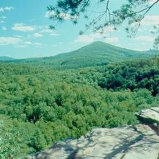
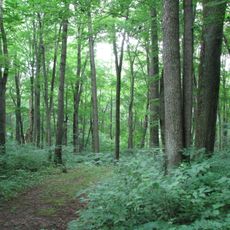
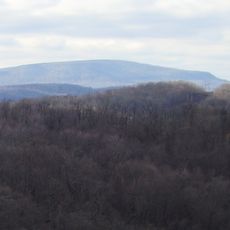
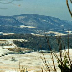
State Game Lands Number 147 is a wildlife conservation area covering approximately 6,100 acres across multiple hills in Blair County. The land consists mainly of deciduous forests with varying elevations that provide habitat for diverse animal species.

The land was established as part of a restoration program when wildlife populations had declined severely in the late 1800s. The Pennsylvania Game Commission worked to rebuild natural habitats and develop hunting grounds on a sustainable basis.

Local residents maintain connections to these lands through seasonal hunting traditions, nature observation activities, and outdoor recreational pursuits throughout the year.

Access to the grounds comes through various roads, including Pennsylvania Route 866 running through the area. Visitors should check local regulations for hunting seasons and use rules, as these vary by time of year.

The area is divided into four separate parcels spread across five different townships. This fragmented layout creates multiple access points and allows visitors to explore several different landscape zones.

The community of curious travelers

AroundUs brings together thousands of curated places, local tips, and hidden gems, enriched daily by 60,000 contributors worldwide.

Start exploring
Location
Location
GPS coordinates
40.35333,-78.33528
Latest update
December 14, 2025 18:02
Around this place
Leap-The-Dips
United States of America

Leap-The-Dips

14.1 km
Lakemont Park
United States of America

Lakemont Park

14.1 km
Railroaders Memorial Museum
United States of America

Railroaders Memorial Museum

18.7 km
Baker Mansion
United States of America

Baker Mansion

16.5 km
United States of America

War Governors' Conference

18.9 km
Canoe Creek State Park
United States of America

Canoe Creek State Park

15.9 km
Skyliner
United States of America

Skyliner

14.2 km
Trough Creek State Park
United States of America

Trough Creek State Park

17.5 km
Warriors Path State Park
United States of America

Warriors Path State Park

18.8 km
Toboggan
United States of America

Toboggan

14.1 km
Highland Hall
United States of America

Highland Hall

10 km
Blair County Courthouse
United States of America

Blair County Courthouse

9.8 km
Ritchey Knob
United States of America

Ritchey Knob

15.7 km
Pine Knob
United States of America

Pine Knob

15.4 km
Lakemont Park
United States of America

Lakemont Park

14 km
Hollidaysburg Historic District
United States of America

Hollidaysburg Historic District

9.8 km
Llyswen Historic District
United States of America

Llyswen Historic District

15.7 km
Allegheny Furnace
United States of America

Allegheny Furnace

16.6 km
Central Trust Company Buildings
United States of America

Central Trust Company Buildings

18.9 km
Williamsburg Historic District
United States of America

Williamsburg Historic District

16.3 km
Brumbaugh Homestead
United States of America

Brumbaugh Homestead

17 km
Broad Avenue Historic District
United States of America

Broad Avenue Historic District

17.8 km
Paradise Furnace
United States of America

Paradise Furnace

18.4 km
Temple Beth Israel
United States of America

Temple Beth Israel

16.8 km
Mount Union Historic District
United States of America

Mount Union Historic District

14.2 km
Marklesburg Historic District
United States of America

Marklesburg Historic District

14.2 km
Daniel Royer House
United States of America

Daniel Royer House

9.6 km
Roaring Spring Historic District
United States of America

Roaring Spring Historic District

5.8 km
Show the full map
Reviews
Share your experience

No review yet

Discussions
Start a discussion...

No discussion yet

« State Game Lands Number 147 - Wildlife conservation area in Blair County, Pennsylvania » is provided by Around Us (aroundus.com). Images and texts are derived from Wikimedia project under a Creative Commons license. You are allowed to copy, distribute, and modify copies of this page, under the conditions set by the license, as long as this note is clearly visible.

Discover hidden gems everywhere you go!

From secret cafés to breathtaking viewpoints, skip the crowded tourist spots and find places that match your style. Our app makes it easy with voice search, smart filtering, route optimization, and insider tips from travelers worldwide. Download now for the complete mobile experience.

Around Us App Screenshot

A unique approach to discovering new places

Le Figaro

All the places worth exploring

France Info

A tailor-made excursion in just a few clicks

20 Minutes

Around Us
Travel Guide & Maps
Download

Send to your phone

QR Code
1

Open the camera app on your mobile.

2

Point at the QR code with your camera. A notification will appear.

3

Tap the notification to open the link.