Enable Location

We need your location to show you interesting places around you

Discover nearby places

Find interesting locations and hidden gems around you

Precise directions

Get accurate directions and distances to places

Your location is never shared with other users. It's only used when you tap the location button.

Puente de Añasco

Log in to your account

Start exploring — it's free

Trusted by 61,940 travelers worldwide

Continue with Google
Continue with Apple
or

We will send you a code to connect

By continuing, you accept our Terms and Conditions and our Privacy Policy

Check your inbox

We've sent a pincode in your inbox. Please enter the code below.

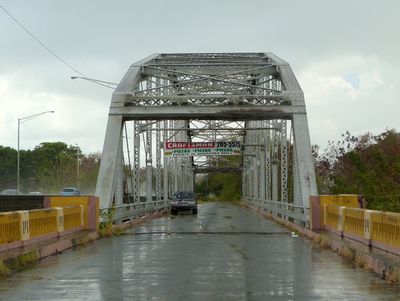
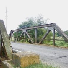
Puente de Añasco, Road bridge in Añasco, Puerto Rico.

The Puente de Añasco is a road bridge with a Pennsylvania through truss design that carries traffic across Highway 2 between Añasco and Mayagüez. The structure spans a river valley and serves as an important link connecting the western side of the island to surrounding communities.

The bridge was constructed around 1944 and links the barrios of Añasco Arriba and Sabanetas across a river. It gained recognition when it was listed in the National Register of Historic Places in 2011 as a notable example of regional engineering from the mid-20th century.

The bridge represents Puerto Rican engineering advancement, forming part of the Historic Bridges of Puerto Rico Multiple Property Submission collection.

The bridge is located on Highway 2 and is easily accessible by vehicle. Visitors should keep in mind that it is an active traffic route, so caution is necessary when crossing or viewing the structure.

The bridge displays construction features that connect it to other historic bridges in the region, showing similarities in the engineering techniques of that era. These shared characteristics allow visitors to understand how bridge-building methods developed across the island.

The community of curious travelers

AroundUs brings together thousands of curated places, local tips, and hidden gems, enriched daily by 60,000 contributors worldwide.

Start exploring
Location
Location
GPS coordinates
18.27260,-67.16168
Latest update
December 14, 2025 15:00
Around this place
BONUS Reactor Facility
United States of America

BONUS Reactor Facility

15.4 km
Dr. Juan A. Rivero Zoo
United States of America

Dr. Juan A. Rivero Zoo

7.3 km
Mayagüez Athletics Stadium
United States of America

Mayagüez Athletics Stadium

9.1 km
Domes Beach
United States of America

Domes Beach

15.4 km
Teatro Yagüez
United States of America

Teatro Yagüez

8.3 km
Minor Basilica of the Virgin of Montserrat
United States of America

Minor Basilica of the Virgin of Montserrat

14.9 km
Isidoro García Stadium
United States of America

Isidoro García Stadium

9 km
Punta Higuero Light
United States of America

Punta Higuero Light

15.2 km
Aguada Stadium
United States of America

Aguada Stadium

12.3 km
Mayagüez City Hall
United States of America

Mayagüez City Hall

8.3 km
Mayagüez Municipal Cemetery
United States of America

Mayagüez Municipal Cemetery

9.3 km
Parque del Litoral
United States of America

Parque del Litoral

8.1 km
Parque de los Próceres
United States of America

Parque de los Próceres

7.8 km
José de Diego Building
United States of America

José de Diego Building

7.4 km
Casa de Piedra
United States of America

Casa de Piedra

16.8 km
Logia Adelphia
United States of America

Logia Adelphia

8.4 km
U.S. Custom House (Mayagüez, Puerto Rico)
United States of America

U.S. Custom House (Mayagüez, Puerto Rico)

7.4 km
El Mani Pavilion
United States of America

El Mani Pavilion

3.1 km
Gómez Residence
United States of America

Gómez Residence

8 km
Pico Piedra
United States of America

Pico Piedra

13.6 km
Puente de Coloso
United States of America

Puente de Coloso

14.1 km
Silva Bridge
United States of America

Silva Bridge

14.9 km
Miguel Angel García Méndez Post Office Building
United States of America

Miguel Angel García Méndez Post Office Building

8.1 km
MUSA Art Museum
Puerto Rico

MUSA Art Museum

7.2 km
Statue of Christopher Columbus (Mayagüez)
United States of America

Statue of Christopher Columbus (Mayagüez)

8.3 km
Columbus Cross
United States of America

Columbus Cross

15.7 km
Manchas Grandes
United States of America

Manchas Grandes

7.3 km
Roca Blanca
United States of America

Roca Blanca

8 km
Show the full map
« Puente de Añasco - Road bridge in Añasco, Puerto Rico » is provided by Around Us (aroundus.com). Images and texts are derived from Wikimedia project under a Creative Commons license. You are allowed to copy, distribute, and modify copies of this page, under the conditions set by the license, as long as this note is clearly visible.

Discover hidden gems everywhere you go!

From secret cafés to breathtaking viewpoints, skip the crowded tourist spots and find places that match your style. Our app makes it easy with voice search, smart filtering, route optimization, and insider tips from travelers worldwide. Download now for the complete mobile experience.

Around Us App Screenshot

A unique approach to discovering new places

Le Figaro

All the places worth exploring

France Info

A tailor-made excursion in just a few clicks

20 Minutes

Around Us
Travel Guide & Maps
Download

Send to your phone

QR Code
1

Open the camera app on your mobile.

2

Point at the QR code with your camera. A notification will appear.

3

Tap the notification to open the link.