Enable Location

We need your location to show you interesting places around you

Discover nearby places

Find interesting locations and hidden gems around you

Precise directions

Get accurate directions and distances to places

Your location is never shared with other users. It's only used when you tap the location button.

Pittsfield State Forest

Log in to your account

Start exploring — it's free

Trusted by 63,189 travelers worldwide

Continue with Google
Continue with Apple
or

We will send you a code to connect

By continuing, you accept our Terms and Conditions and our Privacy Policy

Check your inbox

We've sent a pincode in your inbox. Please enter the code below.

Pittsfield State Forest
Discussion Reviews 1 Photos
3.5k Popularity

Pittsfield State Forest, State forest in Pittsfield, United States.
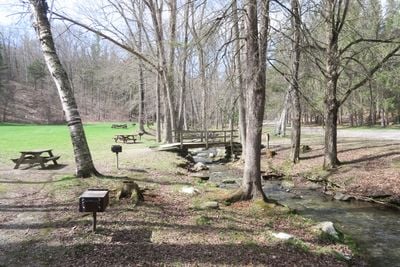
Pittsfield State Forest is a woodland area in western Massachusetts with trails, ponds, and diverse habitats for plants and wildlife. The land spreads across expansive terrain and offers varied landscapes to explore.

The forest was protected during the early 20th-century conservation movement in the United States. This designation was part of a broader effort to safeguard natural lands in Massachusetts.

The forest serves as a place where visitors explore nature and learn about local plant life through their own observations. Many people come to walk the trails and spend time observing the woodland environment.

Wear good hiking boots since the trails have varying difficulty levels and the terrain is hilly. It is best to arrive early, especially on weekends, as popular areas can fill up quickly.

Berry Pond sits within the forest at an elevation of about 2,150 feet (650 meters) and is the highest natural body of water in the state. This feature makes the location particularly interesting for water enthusiasts and nature observers.

The community of curious travelers

AroundUs brings together thousands of curated places, local tips, and hidden gems, enriched daily by 60,000 contributors worldwide.

Start exploring
Location
GPS coordinates
42.48340,-73.30130
Latest update
December 12, 2025 07:56
Around this place
Arrowhead
United States of America

Arrowhead

8.7 km
Berkshire Museum
United States of America

Berkshire Museum

5.6 km
Berkshire Athenaeum
United States of America

Berkshire Athenaeum

5.7 km
United States of America

Shaker Museum and Library

7.2 km
United States of America

Mount Lebanon Shaker Village

7 km
United States of America

Hebert Arboretum

5.2 km
Gov. Samuel J. Tilden Monument
United States of America

Gov. Samuel J. Tilden Monument

7 km
Pittsfield Cemetery
United States of America

Pittsfield Cemetery

4 km
Temple Anshe Amunim
United States of America

Temple Anshe Amunim

6 km
William Russell Allen House
United States of America

William Russell Allen House

6 km
Pilgrim Memorial Church and Parish House
United States of America

Pilgrim Memorial Church and Parish House

4.4 km
Allen Hotel
United States of America

Allen Hotel

5.6 km
Eaton, Crane & Pike Company Factory
United States of America

Eaton, Crane & Pike Company Factory

5.3 km
Springside Park
United States of America

Springside Park

4.9 km
Park Square Historic District
United States of America

Park Square Historic District

5.4 km
Berkshire Life Insurance Company Building
United States of America

Berkshire Life Insurance Company Building

5.4 km
Samuel Harrison House
United States of America

Samuel Harrison House

5.4 km
Hancock Shaker Village
United States of America

Hancock Shaker Village

6.8 km
Providence Court
United States of America

Providence Court

6 km
South Mountain Concert Hall
United States of America

South Mountain Concert Hall

7.3 km
Old Town Hall
United States of America

Old Town Hall

5.6 km
Church of Our Saviour
United States of America

Church of Our Saviour

6.6 km
Lebanon Springs Union Free School
United States of America

Lebanon Springs Union Free School

6.8 km
Wollison-Shipton Building
United States of America

Wollison-Shipton Building

5.4 km
Charles Whittlesey Power House
United States of America

Charles Whittlesey Power House

7.1 km
Hancock Town Hall
United States of America

Hancock Town Hall

7.2 km
Upper North Street Commercial District
United States of America

Upper North Street Commercial District

5.2 km
Nichols-Sterner House
United States of America

Nichols-Sterner House

8.6 km
Show the full map
Reviews
Share your experience

No review yet

Discussions
Start a discussion...

No discussion yet

« Pittsfield State Forest - State forest in Pittsfield, United States » is provided by Around Us (aroundus.com). Images and texts are derived from Wikimedia project under a Creative Commons license. You are allowed to copy, distribute, and modify copies of this page, under the conditions set by the license, as long as this note is clearly visible.

Discover hidden gems everywhere you go!

From secret cafés to breathtaking viewpoints, skip the crowded tourist spots and find places that match your style. Our app makes it easy with voice search, smart filtering, route optimization, and insider tips from travelers worldwide. Download now for the complete mobile experience.

Around Us App Screenshot

A unique approach to discovering new places

Le Figaro

All the places worth exploring

France Info

A tailor-made excursion in just a few clicks

20 Minutes

Around Us
Travel Guide & Maps
Download

Send to your phone

QR Code
1

Open the camera app on your mobile.

2

Point at the QR code with your camera. A notification will appear.

3

Tap the notification to open the link.