Sycamore Gap Tree, Tree landmark at Hadrian's Wall, England
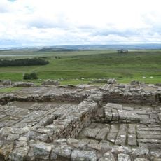
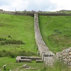
The Sycamore Gap Tree was a sycamore tree that stood between two hills adjacent to the ancient Roman wall in Northumberland. The tree created a natural frame in the landscape and was accessible via walking paths near Hadrian's Wall.
A Newcastle lawyer named John Clayton planted the tree in the late 1800s while dedicating himself to protecting the Roman wall structures. The tree thus became connected to the preservation efforts of this historical site.
The tree became widely known after appearing in the 1991 Robin Hood film, drawing visitors interested in the movie's locations. Its image became closely linked to the landscape of Hadrian's Wall for travelers worldwide.
The location sits along the 84-mile Hadrian's Wall hiking route and is reachable via established walking paths. The area is equipped for hikers and offers straightforward access to the site during a longer walking journey.
The tree was named England's Tree of the Year in 2016, which brought it even greater attention from visitors. In September 2023, the roughly 150-year-old specimen was felled by unknown individuals.
Location: Henshaw
GPS coordinates: 55.00355,-2.37388
Latest update: December 6, 2025 21:31
Vindolanda
1.5 km
Castra Vindolanda
1.6 km
Housesteads Roman Fort
2.9 km
Milecastle 39
120 m
Knag Burn Gateway
3.1 km
Milecastle 37
2.5 km
Milecastle 38
1.2 km
Vindolanda Museum
1.7 km
Milecastle 40
1.6 km
Milecastle 41
3.2 km
Church of All Hallows
3.4 km
Vindolanda Museum
1.8 km
Bardon Mill signal box
3.6 km
Housesteads Mithraeum
3 km
Bardon Mill War Memorial
3.7 km
Hadrians Wall Milecastles And Turrets
1.5 km
Crindledykes Lime Kiln
2 km
Housesteads fort, section of Wall and vallum between the field boundary west of milecastle 36 and the field boundary west of turret 37a in wall miles 36 and 37
2.8 km
Ring cairn and shieling immediately west of Chatley Crags
2.8 km
East Stonefields Farmhouse And Attached Farmbuildings And Walls
3.2 km
Bardon Mill
2.5 km
Uninscribed Roman milestone at Codley Gate (Vindolanda)
1.6 km
Stone circle, defended settlement, Romano-British farmstead and field system, Roman camp and group of shielings immediately sout
2.3 km
Milestone, Winshields
2.6 km
Hadrian's Wall and associated features between the field boundary west of turret 37a and the road to Steel Rigg car park in wall
229 m
Hadrians Wall Milecastle And Turret
3.2 km
Milestone, E of Housesteads Roman Fort; at entrance to "Beggarbog"
3.7 km
Causeway House And Loose Box Adjoining On East
1.4 kmVisited this place? Tap the stars to rate it and share your experience / photos with the community! Try now! You can cancel it anytime.
Discover hidden gems everywhere you go!
From secret cafés to breathtaking viewpoints, skip the crowded tourist spots and find places that match your style. Our app makes it easy with voice search, smart filtering, route optimization, and insider tips from travelers worldwide. Download now for the complete mobile experience.
A unique approach to discovering new places❞
— Le Figaro
All the places worth exploring❞
— France Info
A tailor-made excursion in just a few clicks❞
— 20 Minutes