Chest opened
+${chestReward.xp} XP
Explorer
NOUVEAU ×${chestReward.collectible.quantity}
tapez pour fermer
Chest locked

Open chests in the app

Around Us is built for your phone — chests unlock when you walk, explore and capture nearby places.

Enable Location

We need your location to show you interesting places around you

Discover nearby places

Find interesting locations and hidden gems around you

Precise directions

Get accurate directions and distances to places

Your location is never shared with other users. It's only used when you tap the location button.

Log in to your account

Start exploring — it's free

Trusted by 72,876 travelers worldwide

Continue with Google
Continue with Apple
or

We will send you a code to connect

By continuing, you accept our Terms and Conditions and our Privacy Policy

Check your inbox

We've sent a pincode in your inbox. Please enter the code below.

Ursa tension leg platform
Discussion Reviews Photo
8.2k Popularity

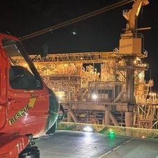
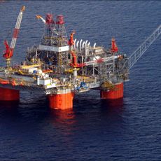
Ursa tension leg platform, Oil drilling platform in Gulf of Mexico, US

The Ursa tension leg platform is an oil production facility in the deep waters of the Gulf of Mexico located well offshore from Louisiana. The structure uses an anchor system with steel cables that keep the platform stable despite strong ocean currents and waves.

The project was designed in the 1990s with construction starting at decade's end as a breakthrough in deep-water drilling. Commercial operations began years later after extensive testing and system verification.

The platform represents how modern energy production is tied to maritime engineering and technical expertise. Visitors can observe from passing vessels how this facility serves as a key part of America's offshore energy operations.

The facility sits over 200 kilometers offshore and is reachable only by helicopter or supply vessel for authorized personnel. Tourists cannot visit the platform itself, though observation from regular shipping routes is possible while maintaining a safe distance.

The platform uses a rare tension leg anchor system where steel cables remain under constant tension to hold the structure in place. This technique enables operations in extreme water depths where traditional anchoring methods cannot work.

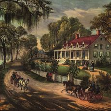
The community of curious travelers

AroundUs brings together thousands of curated places, local tips, and hidden gems, enriched daily by 60,000 contributors worldwide.

Start exploring
Official opening
2009
GPS coordinates
28.15400,-89.10360
Latest update
December 8, 2025 19:58
Around this place
Fort Jackson
United States of America

Fort Jackson

138.3 km
Fort St. Philip
United States of America

Fort St. Philip

139.2 km
Fort Livingston
United States of America

Fort Livingston

149.3 km
United States of America

Louisiana Highway 1 Bridge

160 km
Atlantis PQ
United States of America

Atlantis PQ

140.3 km
Woodland Plantation
United States of America

Woodland Plantation

174.1 km
Grand Isle State Park
United States of America

Grand Isle State Park

148.4 km
Breton National Wildlife Refuge
United States of America

Breton National Wildlife Refuge

189 km
United States of America

Fort De La Boulaye

185.5 km
United States of America

Delta National Wildlife Refuge

122.4 km
Thunder Horse PDQ

Thunder Horse PDQ

60 km
Pass A L'Outre Light
United States of America

Pass A L'Outre Light

115.5 km
Ship Shoal Light
United States of America

Ship Shoal Light

96.1 km
Harlem Plantation House
United States of America

Harlem Plantation House

181.3 km
South Pass Range Lights
United States of America

South Pass Range Lights

96.1 km
Bayou Grande Cheniere Mounds
United States of America

Bayou Grande Cheniere Mounds

163.8 km
United States of America

Pointe-aux-Chenes Wildlife Management Area

192.4 km
United States of America

South Lafourche Bridge

188.4 km
Frank's Island Light
United States of America

Frank's Island Light

110.2 km
St. Patrick's Catholic Church
United States of America

St. Patrick's Catholic Church

153.3 km
United States of America

Golden Meadow Lift Bridge

178.2 km
United States of America

Queen Bess Island Wildlife Refuge

156.6 km
United States of America

Galliano Pontoon Bridge

184 km
United States of America

Le Pont D'or Bridge

196.8 km
United States of America

Lions Park

191.6 km

Multiplex de Grande-Île

148.4 km
United States of America

Plaille de Grande Île

148.2 km
United States of America

Southwest Pass Pilot Station

91.6 km
Show the full map
Reviews
Share your experience

No review yet

Discussions
Start a discussion...

No discussion yet

« Ursa tension leg platform - Oil drilling platform in Gulf of Mexico, US » is provided by Around Us (aroundus.com). Images and texts are derived from Wikimedia project under a Creative Commons license. You are allowed to copy, distribute, and modify copies of this page, under the conditions set by the license, as long as this note is clearly visible.

Discover hidden gems everywhere you go!

From secret cafés to breathtaking viewpoints, skip the crowded tourist spots and find places that match your style. Our app makes it easy with voice search, smart filtering, route optimization, and insider tips from travelers worldwide. Download now for the complete mobile experience.

Around Us App Screenshot

A unique approach to discovering new places

Le Figaro

All the places worth exploring

France Info

A tailor-made excursion in just a few clicks

20 Minutes

Around Us
Travel Guide & Maps
Download

Send to your phone

QR Code
1

Open the camera app on your mobile.

2

Point at the QR code with your camera. A notification will appear.

3

Tap the notification to open the link.