Enable Location

We need your location to show you interesting places around you

Discover nearby places

Find interesting locations and hidden gems around you

Precise directions

Get accurate directions and distances to places

Your location is never shared with other users. It's only used when you tap the location button.

Woodland Plantation

Log in to your account

Start exploring — it's free

Trusted by 62,545 travelers worldwide

Continue with Google
Continue with Apple
or

We will send you a code to connect

By continuing, you accept our Terms and Conditions and our Privacy Policy

Check your inbox

We've sent a pincode in your inbox. Please enter the code below.

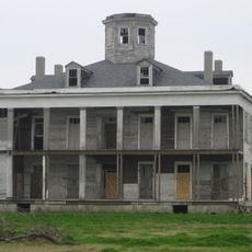
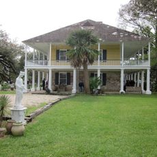
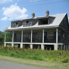
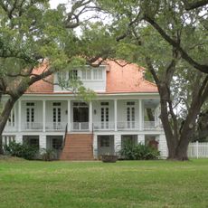
Woodland Plantation, human settlement in United States of America

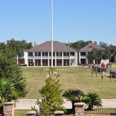
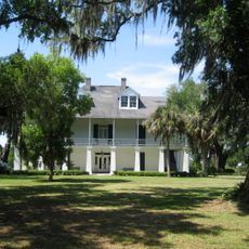
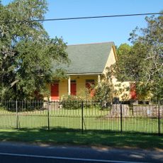
Woodland Plantation is an 1855 house on the west bank of the Mississippi in Louisiana that combines Greek Revival, Italianate, and Gothic Revival elements. The building features tall columns, large windows, and detailed ornamentation and sits on expansive grounds with grass and mature trees, alongside other historic structures including an overseer's house.

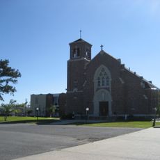
The plantation was established in 1855 as a sugarcane farm and operated as a major agricultural center for over a century. In 1998 the house was added to the National Register of Historic Places and St. Patrick's Catholic Church was relocated to the site to preserve both structures together.

Woodland Plantation served as a social center for the region along the Mississippi for generations. The main house reflects European architectural styles that became rooted in Louisiana and continue to influence how people understand the area's built landscape.

The site is easily reached via Louisiana Highway 23 and offers enough space to explore the historic buildings and surrounding grounds. Visitors should allow time to walk through the rooms and examine the architectural details at a leisurely pace.

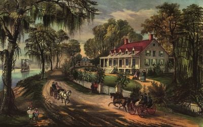
The house was depicted in an 1871 painting by artist Currier and Ives and this image was later used on Southern Comfort liquor bottle labels. The painting became an iconic representation of the plantation and its position on the river until the label changed in 2010.

The community of curious travelers

AroundUs brings together thousands of curated places, local tips, and hidden gems, enriched daily by 60,000 contributors worldwide.

Start exploring
Location
GPS coordinates
29.58406,-89.82690
Latest update
February 7, 2026 11:01
Around this place
Fort Jackson
United States of America

Fort Jackson

44 km
Mississippi River – Gulf Outlet Canal
United States of America

Mississippi River – Gulf Outlet Canal

34.9 km
17th Ward of New Orleans
United States of America

17th Ward of New Orleans

42.1 km
Fort St. Philip
United States of America

Fort St. Philip

43 km
Fort Proctor
United States of America

Fort Proctor

34.6 km
Jackson Barracks
United States of America

Jackson Barracks

44.6 km
Fort Livingston
United States of America

Fort Livingston

36.4 km
12th Ward of New Orleans
United States of America

12th Ward of New Orleans

42.6 km
Grand Isle State Park
United States of America

Grand Isle State Park

38.3 km
Gulf Intracoastal Waterway West Closure Complex
United States of America

Gulf Intracoastal Waterway West Closure Complex

34.8 km
Kenilworth Plantation House
United States of America

Kenilworth Plantation House

31.5 km
LeBeau Plantation
United States of America

LeBeau Plantation

44.1 km
St. Bernard State Park
United States of America

St. Bernard State Park

31.7 km
Mary Plantation House
United States of America

Mary Plantation House

29.7 km
Harlem Plantation House
United States of America

Harlem Plantation House

8.6 km
Bayou Grande Cheniere Mounds
United States of America

Bayou Grande Cheniere Mounds

10.3 km
Judge Perez Bridge
United States of America

Judge Perez Bridge

36.6 km
Promised Land
United States of America

Promised Land

29.1 km
Gretna Historic District
United States of America

Gretna Historic District

43.4 km
Old Jefferson Parish Courthouse
United States of America

Old Jefferson Parish Courthouse

43.6 km
Kerner House
United States of America

Kerner House

44.1 km
St. Patrick's Catholic Church
United States of America

St. Patrick's Catholic Church

24.3 km
Friscoville Street Historic District
United States of America

Friscoville Street Historic District

44.1 km
Los Isleños Museum Complex
United States of America

Los Isleños Museum Complex

32 km
Chalmette Unit of Jean Lafitte National Historical Park
United States of America

Chalmette Unit of Jean Lafitte National Historical Park

43 km
Sebastopol Plantation
United States of America

Sebastopol Plantation

31.9 km
Manila Village
United States of America

Manila Village

33.4 km
Barataria Preserve
United States of America

Barataria Preserve

37.3 km
Show the full map
« Woodland Plantation - human settlement in United States of America » is provided by Around Us (aroundus.com). Images and texts are derived from Wikimedia project under a Creative Commons license. You are allowed to copy, distribute, and modify copies of this page, under the conditions set by the license, as long as this note is clearly visible.

Discover hidden gems everywhere you go!

From secret cafés to breathtaking viewpoints, skip the crowded tourist spots and find places that match your style. Our app makes it easy with voice search, smart filtering, route optimization, and insider tips from travelers worldwide. Download now for the complete mobile experience.

Around Us App Screenshot

A unique approach to discovering new places

Le Figaro

All the places worth exploring

France Info

A tailor-made excursion in just a few clicks

20 Minutes

Around Us
Travel Guide & Maps
Download

Send to your phone

QR Code
1

Open the camera app on your mobile.

2

Point at the QR code with your camera. A notification will appear.

3

Tap the notification to open the link.