Enable Location

We need your location to show you interesting places around you

Discover nearby places

Find interesting locations and hidden gems around you

Precise directions

Get accurate directions and distances to places

Your location is never shared with other users. It's only used when you tap the location button.

Eben ice caves

Log in to your account

Start exploring — it's free

Trusted by 63,227 travelers worldwide

Continue with Google
Continue with Apple
or

We will send you a code to connect

By continuing, you accept our Terms and Conditions and our Privacy Policy

Check your inbox

We've sent a pincode in your inbox. Please enter the code below.

Discussion Reviews 1 Photos 1 Collections
30+ Popularity

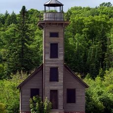
Eben ice caves, Ice cave formation in Rock River Township, US

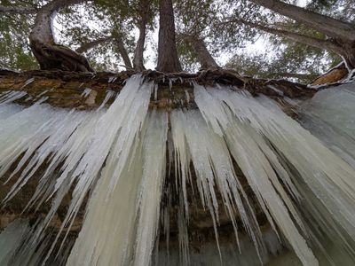
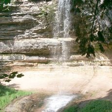
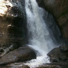
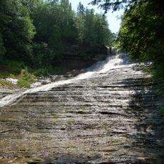
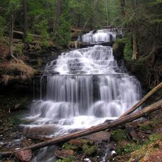
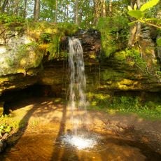
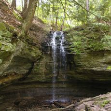
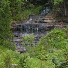
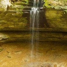
Eben ice caves are formations in Rock River Canyon created by water flowing through sandstone cliffs that freeze into vertical walls during winter. The caves exist only in the coldest months when conditions allow this rare geological display to form.

Early settlers and explorers used the canyon for shelter as they traveled through the region. The ice formations themselves were later discovered by visitors who recognized the site's natural beauty.

The Forest Service organizes public meetings to develop management strategies that protect both the natural environment and visitor experience at the caves.

The route to the caves is moderately difficult and passes through snow-covered forest for roughly 2 km from Swajanen Road. Bring sturdy footwear and crampons to navigate safely on frozen surfaces.

The interaction of water, sandstone, and cedar trees produces yellowish-tinted ice walls that shift their patterns and shapes each season. These changing structures form from varying water flow and freezing rates depending on winter weather conditions.

The community of curious travelers

AroundUs brings together thousands of curated places, local tips, and hidden gems, enriched daily by 60,000 contributors worldwide.

Start exploring
GPS coordinates
46.38134,-86.94309
Latest update
December 6, 2025 19:08
Michigan: the Great Lakes route between stunning nature and American history

From colorful cliffs to waterfalls, Michigan blends wild nature with historic buildings on the shores of the Great Lakes.

Around this place
Marquette Branch Prison
United States of America

Marquette Branch Prison

36.7 km
Grand Island National Recreation Area
United States of America

Grand Island National Recreation Area

25.6 km
Grand Island East Channel Light
United States of America

Grand Island East Channel Light

25.9 km
Munising Falls
United States of America

Munising Falls

25.1 km
Miners Falls
United States of America

Miners Falls

33.3 km
Laughing Whitefish Falls Scenic Site
United States of America

Laughing Whitefish Falls Scenic Site

9.5 km
Wagner Falls Scenic Site
United States of America

Wagner Falls Scenic Site

22.8 km
Wagner Falls
United States of America

Wagner Falls

22.1 km
Scott Falls
United States of America

Scott Falls

12.2 km
Lakenenland
United States of America

Lakenenland

20.3 km
Bridalveil Falls
United States of America

Bridalveil Falls

35.2 km
Tannery Falls
United States of America

Tannery Falls

24.6 km
Onota, Au Train Township, Michigan
United States of America

Onota, Au Train Township, Michigan

19.4 km
Munising Front Range Light
United States of America

Munising Front Range Light

22 km
Grand Island North Light
United States of America

Grand Island North Light

28.3 km
Grand Island Harbor Rear Range Light
United States of America

Grand Island Harbor Rear Range Light

20.3 km
Munising Rear Range Light
United States of America

Munising Rear Range Light

21.7 km
Lakenenland
United States of America

Lakenenland

20.2 km
Alger Falls
United States of America

Alger Falls

22.7 km
Memorial Falls
United States of America

Memorial Falls

24.6 km
King Road–Whitefish River Bridge
United States of America

King Road–Whitefish River Bridge

17.4 km
Old M-94–Au Train River Bridge
United States of America

Old M-94–Au Train River Bridge

10.8 km
Schoolcraft Furnace Site
United States of America

Schoolcraft Furnace Site

25.1 km
M-28–Sand River Bridge
United States of America

M-28–Sand River Bridge

17.9 km
Paulson House
United States of America

Paulson House

7.7 km
Lobb House
United States of America

Lobb House

22.2 km
Grand Island Harbor Front Range Light
United States of America

Grand Island Harbor Front Range Light

20.3 km
Munising School Public Library
United States of America

Munising School Public Library

21.8 km
Show the full map
Reviews
Share your experience

No review yet

Discussions
Start a discussion...

No discussion yet

« Eben ice caves - Ice cave formation in Rock River Township, US » is provided by Around Us (aroundus.com). Images and texts are derived from Wikimedia project under a Creative Commons license. You are allowed to copy, distribute, and modify copies of this page, under the conditions set by the license, as long as this note is clearly visible.

Discover hidden gems everywhere you go!

From secret cafés to breathtaking viewpoints, skip the crowded tourist spots and find places that match your style. Our app makes it easy with voice search, smart filtering, route optimization, and insider tips from travelers worldwide. Download now for the complete mobile experience.

Around Us App Screenshot

A unique approach to discovering new places

Le Figaro

All the places worth exploring

France Info

A tailor-made excursion in just a few clicks

20 Minutes

Around Us
Travel Guide & Maps
Download

Send to your phone

QR Code
1

Open the camera app on your mobile.

2

Point at the QR code with your camera. A notification will appear.

3

Tap the notification to open the link.