Enable Location

We need your location to show you interesting places around you

Discover nearby places

Find interesting locations and hidden gems around you

Precise directions

Get accurate directions and distances to places

Your location is never shared with other users. It's only used when you tap the location button.

El Ojo del Buey

Log in to your account

Start exploring — it's free

Trusted by 63,228 travelers worldwide

Continue with Google
Continue with Apple
or

We will send you a code to connect

By continuing, you accept our Terms and Conditions and our Privacy Policy

Check your inbox

We've sent a pincode in your inbox. Please enter the code below.

El Ojo del Buey
Discussion Reviews 1 Photos
500+ Popularity

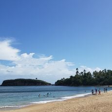
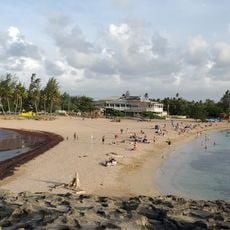
El Ojo del Buey, Beach in Dorado, Puerto Rico, United States.

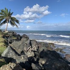
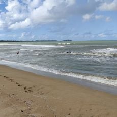
El Ojo del Buey is a beach in Dorado featuring a long stretch of white sand backed by green vegetation and washed by clear Atlantic waters. The shoreline has areas suitable for swimming and relaxation, with natural features distributed along its length.

The beach marks where the Rio de la Plata, Puerto Rico's longest river, meets the Atlantic Ocean and creates a natural boundary between fresh and salt water. This geographic feature has made the area historically significant to communities in the region.

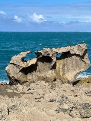
The name comes from a large rock formation shaped like an ox's head, which serves as a natural landmark that local fishermen have used for generations. This distinctive feature has become part of how people identify and talk about this place.

The beach is accessible via Highway 693 from Dorado to Highway 698, where designated parking areas are available. Basic facilities such as showers and restrooms are provided for visitors.

Archaeological excavations near the beach have uncovered pre-Columbian artifacts that reveal the area's importance to indigenous communities before European contact. These discoveries show that this location has a deep history of human settlement and activity.

The community of curious travelers

AroundUs brings together thousands of curated places, local tips, and hidden gems, enriched daily by 60,000 contributors worldwide.

Start exploring
Location
Address
FPGR+FGQ, Calle 13, Dorado, 00646, Puerto Rico
GPS coordinates
18.47594,-66.25762
Latest update
December 14, 2025 20:25
Around this place
Castillo San Felipe del Morro
United States of America

Castillo San Felipe del Morro

14.1 km
San Juan National Historic Site
United States of America

San Juan National Historic Site

14.3 km
Casa Blanca
Puerto Rico

Casa Blanca

14.6 km
Paseo del Morro
United States of America

Paseo del Morro

14.3 km
Puerto Rico National Cemetery
United States of America

Puerto Rico National Cemetery

11.9 km
El Cañuelo
United States of America

El Cañuelo

12.8 km
Ballajá Barracks
United States of America

Ballajá Barracks

14.5 km
Parque de las Ciencias
United States of America

Parque de las Ciencias

12.6 km
El Morro or Port San Juan Light
United States of America

El Morro or Port San Juan Light

14.2 km
Mavilla Bridge
United States of America

Mavilla Bridge

14.4 km
Balneario Cerro Gordo
United States of America

Balneario Cerro Gordo

8.7 km
Inmaculada Concepción Church
United States of America

Inmaculada Concepción Church

10.3 km
Vega State Forest
United States of America

Vega State Forest

11.8 km
Dr. Agustín Stahl Stamm House
United States of America

Dr. Agustín Stahl Stamm House

13.8 km
Bayamón City Hall
United States of America

Bayamón City Hall

13.9 km
Casa Alonso
United States of America

Casa Alonso

14 km
José Celso Barbosa House Museum
United States of America

José Celso Barbosa House Museum

13.9 km
Jacinto Lopez Martinez Grammar School
United States of America

Jacinto Lopez Martinez Grammar School

1.7 km
Playa de Vega Baja
United States of America

Playa de Vega Baja

14.2 km
Museo de las Américas
United States of America

Museo de las Américas

14.6 km
Al-Faruq Mosque
United States of America

Al-Faruq Mosque

10.2 km
Polvorín de Santa Elena (San Juan)
United States of America

Polvorín de Santa Elena (San Juan)

14.3 km
Plaza de Ballajá
United States of America

Plaza de Ballajá

14.5 km
Playa del Dorado
United States of America

Playa del Dorado

144 m
Playa de los Tocones
United States of America

Playa de los Tocones

6.5 km
Playa de Levittown
United States of America

Playa de Levittown

9 km
Playa de Sardinera
United States of America

Playa de Sardinera

3.5 km
Playa de los Cabes
United States of America

Playa de los Cabes

14.5 km
Show the full map
Reviews
Share your experience

No review yet

Discussions
Start a discussion...

No discussion yet

« El Ojo del Buey - Beach in Dorado, Puerto Rico, United States » is provided by Around Us (aroundus.com). Images and texts are derived from Wikimedia project under a Creative Commons license. You are allowed to copy, distribute, and modify copies of this page, under the conditions set by the license, as long as this note is clearly visible.

Discover hidden gems everywhere you go!

From secret cafés to breathtaking viewpoints, skip the crowded tourist spots and find places that match your style. Our app makes it easy with voice search, smart filtering, route optimization, and insider tips from travelers worldwide. Download now for the complete mobile experience.

Around Us App Screenshot

A unique approach to discovering new places

Le Figaro

All the places worth exploring

France Info

A tailor-made excursion in just a few clicks

20 Minutes

Around Us
Travel Guide & Maps
Download

Send to your phone

QR Code
1

Open the camera app on your mobile.

2

Point at the QR code with your camera. A notification will appear.

3

Tap the notification to open the link.