Enable Location

We need your location to show you interesting places around you

Discover nearby places

Find interesting locations and hidden gems around you

Precise directions

Get accurate directions and distances to places

Your location is never shared with other users. It's only used when you tap the location button.

Pancíř

Log in to your account

Start exploring — it's free

Trusted by 63,117 travelers worldwide

Continue with Google
Continue with Apple
or

We will send you a code to connect

By continuing, you accept our Terms and Conditions and our Privacy Policy

Check your inbox

We've sent a pincode in your inbox. Please enter the code below.

Pancíř
Discussion Reviews 1 Photos
1.3k Popularity

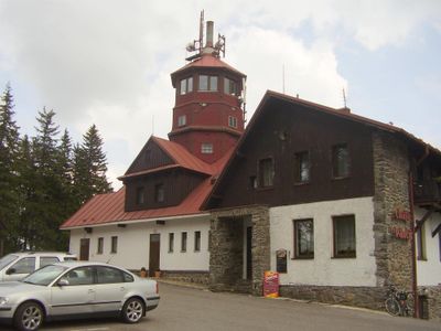
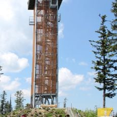
Pancíř, Observation tower in Železná Ruda, Czech Republic.

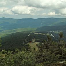
Pancíř is an observation tower in Železná Ruda that stands 18 meters high and provides a panoramic view of the surrounding mountain ranges and forests. From its viewing platform, the structure offers glimpses of the Šumava landscape and the rolling terrain below.

The tower was built as part of a regional tourism development initiative to create observation points across the mountain ranges. It was constructed to give hikers and visitors better access to panoramic views of the landscape.

The tower serves as a gathering point for nature observers and hikers who document the changing seasons throughout the year. People use the location regularly to experience the landscape under different weather conditions.

The tower can be reached via marked hiking trails with rest areas and information boards along the way. The climb is relatively short, but sturdy footwear and weather-appropriate clothing are advisable.

From this vantage point, observers can spot different bird species migrating across the Czech-German border during spring and autumn. The location makes it a good place to watch migratory birds along their natural route.

The community of curious travelers

AroundUs brings together thousands of curated places, local tips, and hidden gems, enriched daily by 60,000 contributors worldwide.

Start exploring
Location
Height
18 m
GPS coordinates
49.17810,13.25390
Latest update
December 14, 2025 17:41
Around this place
Landschaftsschutzgebiet Böhmerwald
Czech Republic

Landschaftsschutzgebiet Böhmerwald

3.2 km
Panzer
Czech Republic

Panzer

29 m
Spitzberg
Czech Republic

Spitzberg

3.4 km
Rozhledna Špičák u Železné Rudy
Czech Republic

Rozhledna Špičák u Železné Rudy

3.4 km
Brückelberg
Czech Republic

Brückelberg

2.7 km
Church of Saint Mary of Help
Czech Republic

Church of Saint Mary of Help

4.8 km
Brčálnické mokřady
Czech Republic

Brčálnické mokřady

2.9 km
Brčálnický jasan
Czech Republic

Brčálnický jasan

2.8 km
Prameniště
Czech Republic

Prameniště

2.3 km
Chapel of Virgin Mary
Czech Republic

Chapel of Virgin Mary

4.4 km
Brčálnická lípa
Czech Republic

Brčálnická lípa

2.7 km
Páteříkova Huť
Czech Republic

Páteříkova Huť

4.6 km
Pomník vojenské vzpoury
Czech Republic

Pomník vojenské vzpoury

4.8 km
Chapel of Saint Anthony of Padua and Saint Barbara (Železná Ruda)
Czech Republic

Chapel of Saint Anthony of Padua and Saint Barbara (Železná Ruda)

4.3 km
Pohřebiště Barabů
Czech Republic

Pohřebiště Barabů

4 km
Pomník osvobození na Klostermannově náměstí v Železné Rudě
Czech Republic

Pomník osvobození na Klostermannově náměstí v Železné Rudě

4.7 km
Usedlost čp. 54
Czech Republic

Usedlost čp. 54

4.3 km
Pomník Petru Kintzlovi u skiareálu ve Špičáku
Czech Republic

Pomník Petru Kintzlovi u skiareálu ve Špičáku

2.9 km
Zámeček Železná Ruda
Czech Republic

Zámeček Železná Ruda

4.7 km
Pomník padlým v 1.světové válce v Železné Rudě
Czech Republic

Pomník padlým v 1.světové válce v Železné Rudě

4.5 km
Kříž u kostela v Železné Rudě
Czech Republic

Kříž u kostela v Železné Rudě

4.8 km
Chapel of Saint Anne
Czech Republic

Chapel of Saint Anne

4.1 km
Kříž v Belvederské ulici v Železné Rudě
Czech Republic

Kříž v Belvederské ulici v Železné Rudě

4.6 km
Boží muka na Křížové cestě v Železné Rudě
Czech Republic

Boží muka na Křížové cestě v Železné Rudě

4.4 km
Kříž u kaple svaté Anny v Železné Rudě
Czech Republic

Kříž u kaple svaté Anny v Železné Rudě

4.1 km
Malá výklenková kaplička nad sjezdovkou pod Belvederem v Železné Rudě
Czech Republic

Malá výklenková kaplička nad sjezdovkou pod Belvederem v Železné Rudě

4 km
Kříž na pohřebišti barabů u cesty ze Špičáku do Železné Rudy
Czech Republic

Kříž na pohřebišti barabů u cesty ze Špičáku do Železné Rudy

4 km
Fara v Železné Rudě
Czech Republic

Fara v Železné Rudě

4.8 km
Show the full map
Reviews
Share your experience

No review yet

Discussions
Start a discussion...

No discussion yet

« Pancíř - Observation tower in Železná Ruda, Czech Republic » is provided by Around Us (aroundus.com). Images and texts are derived from Wikimedia project under a Creative Commons license. You are allowed to copy, distribute, and modify copies of this page, under the conditions set by the license, as long as this note is clearly visible.

Discover hidden gems everywhere you go!

From secret cafés to breathtaking viewpoints, skip the crowded tourist spots and find places that match your style. Our app makes it easy with voice search, smart filtering, route optimization, and insider tips from travelers worldwide. Download now for the complete mobile experience.

Around Us App Screenshot

A unique approach to discovering new places

Le Figaro

All the places worth exploring

France Info

A tailor-made excursion in just a few clicks

20 Minutes

Around Us
Travel Guide & Maps
Download

Send to your phone

QR Code
1

Open the camera app on your mobile.

2

Point at the QR code with your camera. A notification will appear.

3

Tap the notification to open the link.