·

Enable Location

We need your location to show you interesting places around you

Discover nearby places

Find interesting locations and hidden gems around you

Precise directions

Get accurate directions and distances to places

Your location is never shared with other users. It's only used when you tap the location button.

Long Cane Massacre Site

Log in to your account

Start exploring — it's free

Trusted by 62,631 travelers worldwide

Continue with Google
Continue with Apple
or

We will send you a code to connect

By continuing, you accept our Terms and Conditions and our Privacy Policy

Check your inbox

We've sent a pincode in your inbox. Please enter the code below.

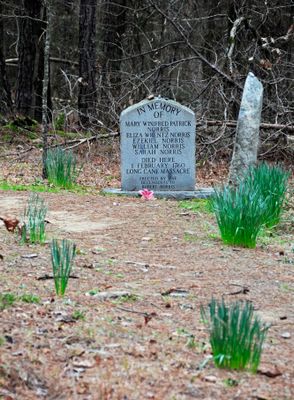
Long Cane Massacre Site, Historic site near Troy, South Carolina.

Long Cane Massacre Site is a historic location in McCormick County, South Carolina, marked by a gravestone commemorating 23 settlers who died during a conflict with Cherokee warriors. The one-acre property sits along a stream crossed by a metal footbridge dating to 1945.

In February 1760, Cherokee warriors attacked a group of Scots-Irish settlers heading toward Fort Moore during rising tensions over land claims. This confrontation became part of the broader conflict that eventually led to negotiations between the two sides.

The site holds the burial place of Catherine Calhoun, grandmother of future US Vice President John C. Calhoun. This connection links the memorial to a prominent American family and the broader story of colonial settlement.

The site can be reached by a dirt road branching off from South Carolina Highway 10 and provides straightforward access to the grounds. Visitors should expect an unpaved approach, especially after rain, but no special equipment or preparation is required.

This location served as a turning point in colonial relations, prompting authorities to establish a formal boundary separating settler and Cherokee territories. The resulting agreement created a defined line that would shape regional boundaries for years to come.

The community of curious travelers

AroundUs brings together thousands of curated places, local tips, and hidden gems, enriched daily by 60,000 contributors worldwide.

Start exploring
Location
GPS coordinates
33.99470,-82.33970
Latest update
December 10, 2025 20:05
Around this place
Elijah Clark State Park
United States of America

Elijah Clark State Park

16.9 km
Richard B. Russell Dam
United States of America

Richard B. Russell Dam

23.7 km
Burt-Stark Mansion
United States of America

Burt-Stark Mansion

21.1 km
Eden Hall
United States of America

Eden Hall

8.1 km
Guillebeau House
United States of America

Guillebeau House

11 km
Abbeville Opera House
United States of America

Abbeville Opera House

20.7 km
Cedar Springs Historic District
United States of America

Cedar Springs Historic District

10.2 km
Barratt House
United States of America

Barratt House

23.4 km
Abbeville Historic District
United States of America

Abbeville Historic District

20.7 km
Abbeville County Courthouse
United States of America

Abbeville County Courthouse

20.7 km
Sylvania
United States of America

Sylvania

9.4 km
Dorn's Flour and Grist Mill
United States of America

Dorn's Flour and Grist Mill

9.9 km
Calhoun Mill
United States of America

Calhoun Mill

13.2 km
Joseph Jennings Dorn House
United States of America

Joseph Jennings Dorn House

10 km
Calhoun-Gibert House
United States of America

Calhoun-Gibert House

12.6 km
Harbison College President's Home
United States of America

Harbison College President's Home

22.8 km
McCormick County Courthouse
United States of America

McCormick County Courthouse

10.2 km
J. Wesley Brooks House
United States of America

J. Wesley Brooks House

25.1 km
Farmer's Bank
United States of America

Farmer's Bank

10.1 km
Otway Henderson House
United States of America

Otway Henderson House

10 km
Lower Long Cane Associate Reformed Presbyterian Church
United States of America

Lower Long Cane Associate Reformed Presbyterian Church

2.5 km
John Albert Gibert M.D. House
United States of America

John Albert Gibert M.D. House

10.6 km
Mount Carmel Historic District
United States of America

Mount Carmel Historic District

15.6 km
Lincolnton Historic District
United States of America

Lincolnton Historic District

26 km
Lincoln County Courthouse
United States of America

Lincoln County Courthouse

25.6 km
Matthews House
United States of America

Matthews House

25.7 km
M.L.B. Sturkey House
United States of America

M.L.B. Sturkey House

10.4 km
Confederate Monument (Abbeville)
United States of America

Confederate Monument (Abbeville)

20.7 km
Show the full map
« Long Cane Massacre Site - Historic site near Troy, South Carolina » is provided by Around Us (aroundus.com). Images and texts are derived from Wikimedia project under a Creative Commons license. You are allowed to copy, distribute, and modify copies of this page, under the conditions set by the license, as long as this note is clearly visible.

Discover hidden gems everywhere you go!

From secret cafés to breathtaking viewpoints, skip the crowded tourist spots and find places that match your style. Our app makes it easy with voice search, smart filtering, route optimization, and insider tips from travelers worldwide. Download now for the complete mobile experience.

Around Us App Screenshot

A unique approach to discovering new places

Le Figaro

All the places worth exploring

France Info

A tailor-made excursion in just a few clicks

20 Minutes

Around Us
Travel Guide & Maps
Download

Send to your phone

QR Code
1

Open the camera app on your mobile.

2

Point at the QR code with your camera. A notification will appear.

3

Tap the notification to open the link.