Chest opened
+${chestReward.xp} XP
Explorer
NOUVEAU ×${chestReward.collectible.quantity}
tapez pour fermer
Chest locked

Open chests in the app

Around Us is built for your phone — chests unlock when you walk, explore and capture nearby places.

Enable Location

We need your location to show you interesting places around you

Discover nearby places

Find interesting locations and hidden gems around you

Precise directions

Get accurate directions and distances to places

Your location is never shared with other users. It's only used when you tap the location button.

Log in to your account

Start exploring — it's free

Trusted by 76,471 travelers worldwide

Continue with Google
Continue with Apple
or

We will send you a code to connect

By continuing, you accept our Terms and Conditions and our Privacy Policy

Check your inbox

We've sent a pincode in your inbox. Please enter the code below.

Blackleaf Formation
Discussion Reviews Photo
1.4k Popularity

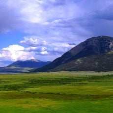
Blackleaf Formation, Geological formation in Beaverhead County, Montana, United States.

Blackleaf Formation is a geological layer in Beaverhead County composed of three mudrock units containing sandstone, mudstone, shale, siltstone, and calcareous deposits. These layers reveal how sediment accumulated in this region over millions of years.

The layer formed between 105 and 94 million years ago during the Lower Cretaceous, when sediments accumulated across southwestern Montana. This period marks a key chapter in the region's geological development.

Scientists study the formation's fossil records, including specimens of Oryctodromeus cubicularis and plant species like Araliaephyllum westonii, to understand prehistoric ecosystems.

This formation is primarily accessible to geology professionals and researchers seeking specialized geological data. Detailed information is documented in scientific publications and geological survey reports.

The lower sections contain fossils of small dinosaurs and ancient plants from different geological periods. These finds help scientists understand which life forms inhabited the region at that time.

The community of curious travelers

AroundUs brings together thousands of curated places, local tips, and hidden gems, enriched daily by 60,000 contributors worldwide.

Start exploring
Location
GPS coordinates
44.50000,-112.60000
Latest update
March 30, 2026 19:48
Around this place
Monida Pass
United States of America

Monida Pass

24.2 km
Clark Canyon Dam
United States of America

Clark Canyon Dam

59.3 km
Red Rock Lakes National Wildlife Refuge
United States of America

Red Rock Lakes National Wildlife Refuge

65.8 km
Camas National Wildlife Refuge
United States of America

Camas National Wildlife Refuge

67.2 km
United States of America

Red Rock Lakes Wilderness

70 km
Birch Creek Charcoal Kilns
United States of America

Birch Creek Charcoal Kilns

50.6 km
Camas Meadows Battle Sites
United States of America

Camas Meadows Battle Sites

55.9 km
United States of America

Mud Lake Wildlife Management Area

69.3 km
United States of America

Mud Lake

71.4 km
Martin Barrett House
United States of America

Martin Barrett House

79.2 km
United States of America

William F. Henneberry Homestead

65.9 km
United States of America

Clark Canyon Reservoir

56.5 km
United States of America

Iron Creek Point

71.7 km
United States of America

Sandhole Lake

70.1 km
United States of America

Reno Point

55.1 km
United States of America

Summit Reservoir

75.4 km
United States of America

Johnston Lake

62.9 km
United States of America

China Point

37.9 km
United States of America

Davis Lake Number One

74.1 km
United States of America

Rays Lake

70.5 km
United States of America

Lima Reservoir

30.2 km
United States of America

Indian Massacre Historical Monument

48.4 km
United States of America

Sheridan Reservoir

71.6 km
United States of America

Clark Canyon Reservoir

56.5 km
United States of America

Civil Defense Caves

76 km
United States of America

University of Montana Western Gallery

79 km
United States of America

Scenic viewpoint

58.7 km
United States of America

Waterfall

60.6 km
Show the full map
Reviews
Share your experience

No review yet

Discussions
Start a discussion...

No discussion yet

« Blackleaf Formation - Geological formation in Beaverhead County, Montana, United States » is provided by Around Us (aroundus.com). Images and texts are derived from Wikimedia project under a Creative Commons license. You are allowed to copy, distribute, and modify copies of this page, under the conditions set by the license, as long as this note is clearly visible.

Discover hidden gems everywhere you go!

From secret cafés to breathtaking viewpoints, skip the crowded tourist spots and find places that match your style. Our app makes it easy with voice search, smart filtering, route optimization, and insider tips from travelers worldwide. Download now for the complete mobile experience.

Around Us App Screenshot

A unique approach to discovering new places

Le Figaro

All the places worth exploring

France Info

A tailor-made excursion in just a few clicks

20 Minutes

Around Us
Travel Guide & Maps
Download

Send to your phone

QR Code
1

Open the camera app on your mobile.

2

Point at the QR code with your camera. A notification will appear.

3

Tap the notification to open the link.