Enable Location

We need your location to show you interesting places around you

Discover nearby places

Find interesting locations and hidden gems around you

Precise directions

Get accurate directions and distances to places

Your location is never shared with other users. It's only used when you tap the location button.

Oregon Creek Covered Bridge

Log in to your account

Start exploring — it's free

Trusted by 63,039 travelers worldwide

Continue with Google
Continue with Apple
or

We will send you a code to connect

By continuing, you accept our Terms and Conditions and our Privacy Policy

Check your inbox

We've sent a pincode in your inbox. Please enter the code below.

Discussion Reviews 1 Photos
1.7k Popularity

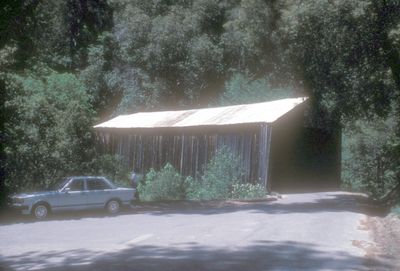
Oregon Creek Covered Bridge, Covered bridge in Yuba County, California

The Oregon Creek Covered Bridge is a wooden structure that crosses Oregon Creek near where it meets the Middle Yuba River in Tahoe National Forest. The bridge spans approximately 101 feet and displays the typical covered design of wooden bridges from that time period.

The structure was built in 1860 to serve mining and logging communities during the Nevada mining expansion period. After a flood in 1883, it was relocated back to its position, which unintentionally altered its orientation.

The bridge displays nineteenth-century craftsmanship through its Queen post truss design and curved portal entrances at each end. Visitors can observe these features while crossing and see how builders of that era used wood and basic techniques to create lasting structures.

The bridge sits approximately 20 miles northwest of Nevada City on Highway 49 and has a weight restriction of about 5 tons. The surrounding area offers picnic spots and is easily accessible by the same road.

After a flood in 1883, workers used oxen to haul the displaced bridge back to its position. The structure was inadvertently reinstalled in reverse, a quirk that has remained ever since.

The community of curious travelers

AroundUs brings together thousands of curated places, local tips, and hidden gems, enriched daily by 60,000 contributors worldwide.

Start exploring
Location
Inception
1860
Official opening
1860
GPS coordinates
39.39690,-121.08200
Latest update
December 14, 2025 12:21
Around this place
Empire Mine State Historic Park
United States of America

Empire Mine State Historic Park

21.8 km
New Bullards Bar Reservoir
United States of America

New Bullards Bar Reservoir

5 km
New Bullards Bar Dam
United States of America

New Bullards Bar Dam

5.3 km
South Yuba River State Park
United States of America

South Yuba River State Park

15.1 km
Bridgeport Covered Bridge
United States of America

Bridgeport Covered Bridge

15.1 km
Scotts Flat Reservoir
United States of America

Scotts Flat Reservoir

19 km
Englebright Lake
United States of America

Englebright Lake

23.8 km
Home of Lola Montez
United States of America

Home of Lola Montez

20.1 km
North Star House
United States of America

North Star House

22.6 km
National Exchange Hotel
United States of America

National Exchange Hotel

16 km
Nevada City Downtown Historic District
United States of America

Nevada City Downtown Historic District

15.8 km
Englebright Dam
United States of America

Englebright Dam

23.8 km
Mount Saint Mary's Convent and Academy
United States of America

Mount Saint Mary's Convent and Academy

20.3 km
Nevada Brewery
United States of America

Nevada Brewery

16.1 km
Nevada Theatre
United States of America

Nevada Theatre

15.8 km
Grass Valley Public Library
United States of America

Grass Valley Public Library

20.2 km
Maria's
United States of America

Maria's

19.8 km
Doris Foley Library for Historical Research
United States of America

Doris Foley Library for Historical Research

15.8 km
Collins Lake Beach
United States of America

Collins Lake Beach

21.9 km
Martin Luther Marsh House
United States of America

Martin Luther Marsh House

15.7 km
Trinity Church (Nevada City)
United States of America

Trinity Church (Nevada City)

15.9 km
Aaron A. Sargent House
United States of America

Aaron A. Sargent House

15.8 km
Ott's Assay Office
United States of America

Ott's Assay Office

16 km
Prosperity Lanes
United States of America

Prosperity Lanes

20.3 km
Hoyt Crossing Nude Beach
United States of America

Hoyt Crossing Nude Beach

10.5 km
Northstar Mining Museum
United States of America

Northstar Mining Museum

21 km
Purdon Crossing Bridge
United States of America

Purdon Crossing Bridge

8.3 km
Grass Valley Library-Royce Branch
United States of America

Grass Valley Library-Royce Branch

20.1 km
Show the full map
Reviews
Share your experience

No review yet

Discussions
Start a discussion...

No discussion yet

« Oregon Creek Covered Bridge - Covered bridge in Yuba County, California » is provided by Around Us (aroundus.com). Images and texts are derived from Wikimedia project under a Creative Commons license. You are allowed to copy, distribute, and modify copies of this page, under the conditions set by the license, as long as this note is clearly visible.

Discover hidden gems everywhere you go!

From secret cafés to breathtaking viewpoints, skip the crowded tourist spots and find places that match your style. Our app makes it easy with voice search, smart filtering, route optimization, and insider tips from travelers worldwide. Download now for the complete mobile experience.

Around Us App Screenshot

A unique approach to discovering new places

Le Figaro

All the places worth exploring

France Info

A tailor-made excursion in just a few clicks

20 Minutes

Around Us
Travel Guide & Maps
Download

Send to your phone

QR Code
1

Open the camera app on your mobile.

2

Point at the QR code with your camera. A notification will appear.

3

Tap the notification to open the link.