Enable Location

We need your location to show you interesting places around you

Discover nearby places

Find interesting locations and hidden gems around you

Precise directions

Get accurate directions and distances to places

Your location is never shared with other users. It's only used when you tap the location button.

Englebright Dam

Log in to your account

Start exploring — it's free

Trusted by 62,614 travelers worldwide

Continue with Google
Continue with Apple
or

We will send you a code to connect

By continuing, you accept our Terms and Conditions and our Privacy Policy

Check your inbox

We've sent a pincode in your inbox. Please enter the code below.

Englebright Dam

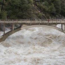
Englebright Dam, Concrete arch dam in Yuba and Nevada Counties, California, US

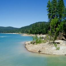
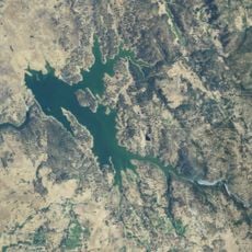
Englebright Dam is a concrete arch dam spanning the Yuba River gorge in northern California. The reservoir extends for several miles through a rocky canyon and creates a deep lake surrounded by steep cliff walls.

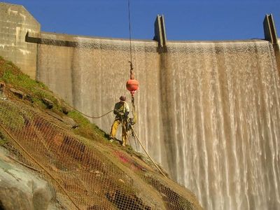
The structure was built in 1941 by the United States Army Corps of Engineers to address sediment from hydraulic mining operations in the Yuba River watershed. This construction was a response to environmental problems caused by intensive mining activity in the region.

The dam bears the name of Harry Lane Englebright, a mining engineer and United States House Representative who served as House minority whip from 1933 to 1943.

Access to the lake is by boat, since all camping spots can only be reached from the water. The shores are rocky and winding, offering a natural experience away from roads.

The reservoir is known for its remote campsites that are only accessible by boat, each with tables and fire grills for cooking. This isolated setting attracts visitors seeking solitude and a break from developed areas.

The community of curious travelers

AroundUs brings together thousands of curated places, local tips, and hidden gems, enriched daily by 60,000 contributors worldwide.

Start exploring
Location
Location
GPS coordinates
39.24000,-121.26900
Latest update
December 12, 2025 17:42
Around this place
Empire Mine State Historic Park
United States of America

Empire Mine State Historic Park

19.9 km
New Bullards Bar Reservoir
United States of America

New Bullards Bar Reservoir

20.3 km
New Bullards Bar Dam
United States of America

New Bullards Bar Dam

20.2 km
South Yuba River State Park
United States of America

South Yuba River State Park

8.7 km
Bridgeport Covered Bridge
United States of America

Bridgeport Covered Bridge

8.7 km
Scotts Flat Reservoir
United States of America

Scotts Flat Reservoir

29.4 km
Englebright Lake
United States of America

Englebright Lake

114 m
Home of Lola Montez
United States of America

Home of Lola Montez

17.9 km
Camp Far West Reservoir
United States of America

Camp Far West Reservoir

21.3 km
Ellis Lake
United States of America

Ellis Lake

29.3 km
North Star House
United States of America

North Star House

17.4 km
Nevada City Downtown Historic District
United States of America

Nevada City Downtown Historic District

21.7 km
Mount Saint Mary's Convent and Academy
United States of America

Mount Saint Mary's Convent and Academy

17.6 km
Nevada Theatre
United States of America

Nevada Theatre

21.6 km
Grass Valley Public Library
United States of America

Grass Valley Public Library

17.9 km
Oregon Creek Covered Bridge
United States of America

Oregon Creek Covered Bridge

23.8 km
Doris Foley Library for Historical Research
United States of America

Doris Foley Library for Historical Research

21.7 km
Hart Building
United States of America

Hart Building

29.8 km
Packard Library
United States of America

Packard Library

29.7 km
Martin Luther Marsh House
United States of America

Martin Luther Marsh House

22.6 km
Trinity Church (Nevada City)
United States of America

Trinity Church (Nevada City)

22 km
Aaron A. Sargent House
United States of America

Aaron A. Sargent House

21.6 km
Ott's Assay Office
United States of America

Ott's Assay Office

22 km
Northstar Mining Museum
United States of America

Northstar Mining Museum

17.5 km
Grass Valley Library-Royce Branch
United States of America

Grass Valley Library-Royce Branch

17.9 km
Purdon Crossing Bridge
United States of America

Purdon Crossing Bridge

21.5 km
Freeman's Crossing Bridge
United States of America

Freeman's Crossing Bridge

23.4 km
Yuba County Library
United States of America

Yuba County Library

29.8 km
Show the full map
« Englebright Dam - Concrete arch dam in Yuba and Nevada Counties, California, US » is provided by Around Us (aroundus.com). Images and texts are derived from Wikimedia project under a Creative Commons license. You are allowed to copy, distribute, and modify copies of this page, under the conditions set by the license, as long as this note is clearly visible.

Discover hidden gems everywhere you go!

From secret cafés to breathtaking viewpoints, skip the crowded tourist spots and find places that match your style. Our app makes it easy with voice search, smart filtering, route optimization, and insider tips from travelers worldwide. Download now for the complete mobile experience.

Around Us App Screenshot

A unique approach to discovering new places

Le Figaro

All the places worth exploring

France Info

A tailor-made excursion in just a few clicks

20 Minutes

Around Us
Travel Guide & Maps
Download

Send to your phone

QR Code
1

Open the camera app on your mobile.

2

Point at the QR code with your camera. A notification will appear.

3

Tap the notification to open the link.