Enable Location

We need your location to show you interesting places around you

Discover nearby places

Find interesting locations and hidden gems around you

Precise directions

Get accurate directions and distances to places

Your location is never shared with other users. It's only used when you tap the location button.

Scotts Flat Reservoir

Log in to your account

Start exploring — it's free

Trusted by 62,374 travelers worldwide

Continue with Google
Continue with Apple
or

We will send you a code to connect

By continuing, you accept our Terms and Conditions and our Privacy Policy

Check your inbox

We've sent a pincode in your inbox. Please enter the code below.

Scotts Flat Reservoir

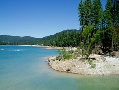
Scotts Flat Reservoir, body of water

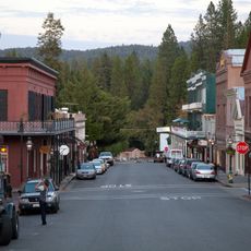
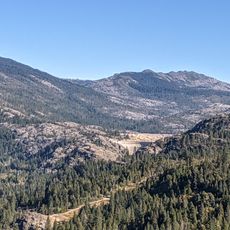
Scotts Flat Reservoir is a body of water in the Sierra Foothills, about 9 miles east of Nevada City, surrounded by tall evergreen trees. Fed by Deer Creek, the water is typically clear and calm, covering about 850 acres. Two boat launch ramps and a marina facilitate various water activities, while jet skis and similar personal watercraft are prohibited to maintain the quiet setting.

The dam was constructed as part of the water management infrastructure and is managed by the Nevada Irrigation District along with other reservoirs to supply water to nearby communities and farmland. Over the decades, the site has developed into a recreation destination, with events like the Go for the Gold Regatta spanning more than 40 years.

The lake serves the local community as a gathering place for water sports and outdoor recreation. Annual events like the 'Go for the Gold Regatta' and the designated 'No Motor Day' in May reflect how visitors value both active recreation and peaceful experiences on the water.

Arrive early in the day, especially during summer, as day-use areas fill up quickly. Making advance reservations at nearby campgrounds or staying in Nevada City overnight can help ensure a more comfortable visit and better access to the lake's amenities.

This is one of California's top destinations for stand-up paddleboarding, thanks to its gentle waves and calm conditions. Night paddling under a starlit sky is a lesser-known option that offers a peaceful and different way to experience the lake after sunset.

The community of curious travelers

AroundUs brings together thousands of curated places, local tips, and hidden gems, enriched daily by 60,000 contributors worldwide.

Start exploring
Location
GPS coordinates
39.27270,-120.93050
Latest update
February 7, 2026 11:01
Around this place
Interstate 80 in California
United States of America

Interstate 80 in California

27.7 km
Empire Mine State Historic Park
United States of America

Empire Mine State Historic Park

12.4 km
Tahoe National Forest
United States of America

Tahoe National Forest

32.7 km
New Bullards Bar Reservoir
United States of America

New Bullards Bar Reservoir

22.5 km
Emigrant Gap
United States of America

Emigrant Gap

23 km
New Bullards Bar Dam
United States of America

New Bullards Bar Dam

22.7 km
South Yuba River State Park
United States of America

South Yuba River State Park

22.9 km
Bridgeport Covered Bridge
United States of America

Bridgeport Covered Bridge

22.9 km
Sugar Pine Reservoir
United States of America

Sugar Pine Reservoir

19.5 km
Englebright Lake
United States of America

Englebright Lake

29.5 km
Home of Lola Montez
United States of America

Home of Lola Montez

13.1 km
North Star House
United States of America

North Star House

15.3 km
Nevada City Downtown Historic District
United States of America

Nevada City Downtown Historic District

7.7 km
Lake Spaulding Dam
United States of America

Lake Spaulding Dam

25.5 km
Englebright Dam
United States of America

Englebright Dam

29.4 km
Mount Saint Mary's Convent and Academy
United States of America

Mount Saint Mary's Convent and Academy

13.4 km
Nevada Theatre
United States of America

Nevada Theatre

7.8 km
Grass Valley Public Library
United States of America

Grass Valley Public Library

13.1 km
Oregon Creek Covered Bridge
United States of America

Oregon Creek Covered Bridge

19 km
Doris Foley Library for Historical Research
United States of America

Doris Foley Library for Historical Research

7.7 km
Martin Luther Marsh House
United States of America

Martin Luther Marsh House

6.8 km
Trinity Church (Nevada City)
United States of America

Trinity Church (Nevada City)

7.4 km
Aaron A. Sargent House
United States of America

Aaron A. Sargent House

7.8 km
Ott's Assay Office
United States of America

Ott's Assay Office

7.4 km
Northstar Mining Museum
United States of America

Northstar Mining Museum

14 km
Purdon Crossing Bridge
United States of America

Purdon Crossing Bridge

11.7 km
Grass Valley Library-Royce Branch
United States of America

Grass Valley Library-Royce Branch

13 km
Freeman's Crossing Bridge
United States of America

Freeman's Crossing Bridge

19 km
Show the full map
« Scotts Flat Reservoir - body of water » is provided by Around Us (aroundus.com). Images and texts are derived from Wikimedia project under a Creative Commons license. You are allowed to copy, distribute, and modify copies of this page, under the conditions set by the license, as long as this note is clearly visible.

Discover hidden gems everywhere you go!

From secret cafés to breathtaking viewpoints, skip the crowded tourist spots and find places that match your style. Our app makes it easy with voice search, smart filtering, route optimization, and insider tips from travelers worldwide. Download now for the complete mobile experience.

Around Us App Screenshot

A unique approach to discovering new places

Le Figaro

All the places worth exploring

France Info

A tailor-made excursion in just a few clicks

20 Minutes

Around Us
Travel Guide & Maps
Download

Send to your phone

QR Code
1

Open the camera app on your mobile.

2

Point at the QR code with your camera. A notification will appear.

3

Tap the notification to open the link.