Enable Location

We need your location to show you interesting places around you

Discover nearby places

Find interesting locations and hidden gems around you

Precise directions

Get accurate directions and distances to places

Your location is never shared with other users. It's only used when you tap the location button.

Sugar Pine Reservoir

Log in to your account

Start exploring — it's free

Trusted by 62,376 travelers worldwide

Continue with Google
Continue with Apple
or

We will send you a code to connect

By continuing, you accept our Terms and Conditions and our Privacy Policy

Check your inbox

We've sent a pincode in your inbox. Please enter the code below.

Sugar Pine Reservoir

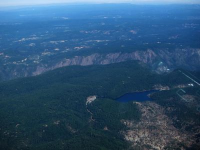
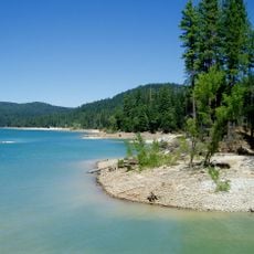
Sugar Pine Reservoir, body of water

Sugar Pine Reservoir is a large lake in California with clear water and campgrounds along the shoreline. The site includes a boat ramp, swimming area, picnic spots, and a paved trail around the water that serves hikers and non-motorized visitors.

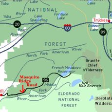
Sugar Pine Reservoir was created by the construction of a dam across Shirttail Creek as part of water management efforts. The lake opened to visitors in 1985 and has since become a popular outdoor recreation destination.

The name comes from the tall sugar pine trees that line the shoreline and shape the landscape. This quiet setting attracts families and outdoor enthusiasts who come to spend time in a peaceful natural environment away from busy areas.

The lake is open year-round but most popular during warmer months. Boats are limited to 10 mph speed, and off-highway vehicles are restricted to a nearby staging area to keep the main complex quiet and safe for all visitors.

The lake is known for its calm water surface and abundance of birdlife, especially visible during early mornings or late afternoons. The low boat speed limit and limited motorboat use make it one of the quietest places for water-based recreation in the region.

The community of curious travelers

AroundUs brings together thousands of curated places, local tips, and hidden gems, enriched daily by 60,000 contributors worldwide.

Start exploring
Location
GPS coordinates
39.13390,-120.79200
Latest update
February 7, 2026 11:00
Around this place
Foresthill Bridge
United States of America

Foresthill Bridge

31.8 km
Empire Mine State Historic Park
United States of America

Empire Mine State Historic Park

23 km
Emigrant Gap
United States of America

Emigrant Gap

21.7 km
Auburn State Recreation Area
United States of America

Auburn State Recreation Area

17.7 km
Lake Clementine
United States of America

Lake Clementine

28.6 km
Scotts Flat Reservoir
United States of America

Scotts Flat Reservoir

19.5 km
Home of Lola Montez
United States of America

Home of Lola Montez

25.2 km
French Meadows Reservoir
United States of America

French Meadows Reservoir

28.1 km
United States of America

Placer County Big Trees Grove

20.5 km
North Star House
United States of America

North Star House

25.4 km
National Exchange Hotel
United States of America

National Exchange Hotel

24.1 km
Nevada City Downtown Historic District
United States of America

Nevada City Downtown Historic District

24.3 km
Lake Spaulding Dam
United States of America

Lake Spaulding Dam

25.1 km
Mount Saint Mary's Convent and Academy
United States of America

Mount Saint Mary's Convent and Academy

25.4 km
Nevada Brewery
United States of America

Nevada Brewery

23.9 km
Nevada Theatre
United States of America

Nevada Theatre

24.4 km
Grass Valley Public Library
United States of America

Grass Valley Public Library

25.2 km
Maria's
United States of America

Maria's

24.9 km
Doris Foley Library for Historical Research
United States of America

Doris Foley Library for Historical Research

24.3 km
Martin Luther Marsh House
United States of America

Martin Luther Marsh House

23.9 km
Trinity Church (Nevada City)
United States of America

Trinity Church (Nevada City)

24.1 km
Aaron A. Sargent House
United States of America

Aaron A. Sargent House

24.4 km
Ott's Assay Office
United States of America

Ott's Assay Office

24.1 km
Prosperity Lanes
United States of America

Prosperity Lanes

24.6 km
Hoyt Crossing Nude Beach
United States of America

Hoyt Crossing Nude Beach

31.2 km
Northstar Mining Museum
United States of America

Northstar Mining Museum

25.4 km
Purdon Crossing Bridge
United States of America

Purdon Crossing Bridge

30.8 km
Grass Valley Library-Royce Branch
United States of America

Grass Valley Library-Royce Branch

25.2 km
Show the full map
« Sugar Pine Reservoir - body of water » is provided by Around Us (aroundus.com). Images and texts are derived from Wikimedia project under a Creative Commons license. You are allowed to copy, distribute, and modify copies of this page, under the conditions set by the license, as long as this note is clearly visible.

Discover hidden gems everywhere you go!

From secret cafés to breathtaking viewpoints, skip the crowded tourist spots and find places that match your style. Our app makes it easy with voice search, smart filtering, route optimization, and insider tips from travelers worldwide. Download now for the complete mobile experience.

Around Us App Screenshot

A unique approach to discovering new places

Le Figaro

All the places worth exploring

France Info

A tailor-made excursion in just a few clicks

20 Minutes

Around Us
Travel Guide & Maps
Download

Send to your phone

QR Code
1

Open the camera app on your mobile.

2

Point at the QR code with your camera. A notification will appear.

3

Tap the notification to open the link.