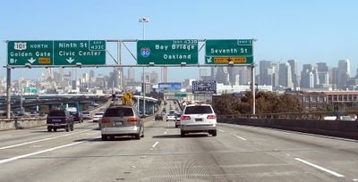
Interstate 80 in California, Major interstate highway in northern California, US
Interstate 80 in California is a major federal highway running from the Bay Area through the Central Valley to the Nevada border. It crosses the San Francisco-Oakland Bay Bridge, passes through Sacramento, and then climbs through several mountain passes in the Sierra Nevada.
The highway officially opened on July 1, 1964, replacing US Route 40 as the main link between the Pacific coast and the eastern United States. Its alignment follows in part the historic Emigrant Trail and the first transcontinental railroad route through the Sierra Nevada.
The route serves as the main corridor for commuters traveling between San Francisco and the state capital Sacramento, while its mountain section attracts weekend skiers and travelers heading to Nevada. Local stories about snowstorms and pass crossings form part of everyday conversation among residents in the high country.
Real-time road conditions and alerts are available by calling Caltrans at 1-800-427-7623 or checking the QuickMap service online. During winter months, chain requirements in the mountain section are common, so checking conditions before traveling is advisable.
At Donner Summit, the interstate reaches an elevation of 7239 feet (2206 m) westbound and 7227 feet (2203 m) eastbound, making it one of the highest interstate sections in the country. This section closely follows the path of the Donner Party of 1846, whose dramatic winter story is recounted at a museum near the pass.
The community of curious travelers
AroundUs brings together thousands of curated places, local tips, and hidden gems, enriched daily by 60,000 contributors worldwide.