Enable Location

We need your location to show you interesting places around you

Discover nearby places

Find interesting locations and hidden gems around you

Precise directions

Get accurate directions and distances to places

Your location is never shared with other users. It's only used when you tap the location button.

Ellis Lake

Log in to your account

Start exploring — it's free

Trusted by 62,386 travelers worldwide

Continue with Google
Continue with Apple
or

We will send you a code to connect

By continuing, you accept our Terms and Conditions and our Privacy Policy

Check your inbox

We've sent a pincode in your inbox. Please enter the code below.

Ellis Lake

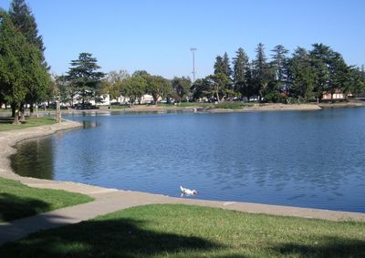
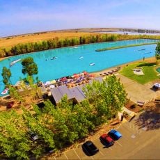
Ellis Lake, Man-made lake

Ellis Lake is a man-made reservoir in downtown Marysville with walking trails circling the water and picnic areas along the shore. The roughly 1.2-mile path passes small islands in the lake, including one with a gazebo that visitors can view from the banks.

The site changed from a swampy Feather River spillway into the current lake in the 1930s, finished by 1939. A landscape designer and local visionary W. T. Ellis worked to transform it into the community gathering place it remains today.

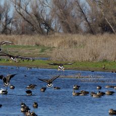
The lake is woven into daily life in Marysville, drawing families and locals seeking outdoor moments. Ducks, geese, and other birds are permanent residents that visitors observe and feed along the walking paths.

Parking is readily available and benches line the walking route for rest and observation. Visit during clear weather when the park feels quiet and birds are most active along the water.

A woman's car was found at the lake bottom in 2002 after disappearing decades earlier in the 1980s, adding to local lore. A modern lighting system on one of the islands displays 37 colors and illuminates the water from dusk until midnight.

The community of curious travelers

AroundUs brings together thousands of curated places, local tips, and hidden gems, enriched daily by 60,000 contributors worldwide.

Start exploring
Location
GPS coordinates
39.14778,-121.58722
Latest update
February 7, 2026 11:40
Around this place
South Yuba River State Park
United States of America

South Yuba River State Park

37.5 km
Bridgeport Covered Bridge
United States of America

Bridgeport Covered Bridge

37.5 km
Bok Kai Temple
United States of America

Bok Kai Temple

1.4 km
Englebright Lake
United States of America

Englebright Lake

29.2 km
Camp Far West Reservoir
United States of America

Camp Far West Reservoir

25.9 km
Colusa National Wildlife Refuge
United States of America

Colusa National Wildlife Refuge

39.4 km
Sutter National Wildlife Refuge
United States of America

Sutter National Wildlife Refuge

16.3 km
Fremont Weir Wildlife Area
United States of America

Fremont Weir Wildlife Area

44.6 km
Oroville Chinese Temple
United States of America

Oroville Chinese Temple

40.8 km
North Star House
United States of America

North Star House

44.4 km
Englebright Dam
United States of America

Englebright Dam

29.3 km
Old Bidwell Bar Bridge
United States of America

Old Bidwell Bar Bridge

44.9 km
Community Memorial Museum of Sutter County
United States of America

Community Memorial Museum of Sutter County

4.2 km
Live Oak Historic Commercial District
United States of America

Live Oak Historic Commercial District

15.5 km
Yuba City Astronomical Observatory
United States of America

Yuba City Astronomical Observatory

5.5 km
Grand Island Shrine
United States of America

Grand Island Shrine

30.3 km
Hart Building
United States of America

Hart Building

935 m
Wake Island Water Park
United States of America

Wake Island Water Park

44.7 km
Collins Lake Beach
United States of America

Collins Lake Beach

30.8 km
Packard Library
United States of America

Packard Library

909 m
Colusa County Courthouse
United States of America

Colusa County Courthouse

37.1 km
Wheatland Masonic Temple
United States of America

Wheatland Masonic Temple

20.9 km
Marysville Historic Commercial District
United States of America

Marysville Historic Commercial District

1.1 km
Oroville Carnegie Library
United States of America

Oroville Carnegie Library

40.7 km
West Butte Schoolhouse
United States of America

West Butte Schoolhouse

25.5 km
Oroville Chinese Temple
United States of America

Oroville Chinese Temple

40.8 km
Oroville State Theatre
United States of America

Oroville State Theatre

40.7 km
Yuba County Library
United States of America

Yuba County Library

1.1 km
Show the full map
« Ellis Lake - Man-made lake » is provided by Around Us (aroundus.com). Images and texts are derived from Wikimedia project under a Creative Commons license. You are allowed to copy, distribute, and modify copies of this page, under the conditions set by the license, as long as this note is clearly visible.

Discover hidden gems everywhere you go!

From secret cafés to breathtaking viewpoints, skip the crowded tourist spots and find places that match your style. Our app makes it easy with voice search, smart filtering, route optimization, and insider tips from travelers worldwide. Download now for the complete mobile experience.

Around Us App Screenshot

A unique approach to discovering new places

Le Figaro

All the places worth exploring

France Info

A tailor-made excursion in just a few clicks

20 Minutes

Around Us
Travel Guide & Maps
Download

Send to your phone

QR Code
1

Open the camera app on your mobile.

2

Point at the QR code with your camera. A notification will appear.

3

Tap the notification to open the link.