Enable Location

We need your location to show you interesting places around you

Discover nearby places

Find interesting locations and hidden gems around you

Precise directions

Get accurate directions and distances to places

Your location is never shared with other users. It's only used when you tap the location button.

Sutter National Wildlife Refuge

Log in to your account

Start exploring — it's free

Trusted by 63,015 travelers worldwide

Continue with Google
Continue with Apple
or

We will send you a code to connect

By continuing, you accept our Terms and Conditions and our Privacy Policy

Check your inbox

We've sent a pincode in your inbox. Please enter the code below.

Sutter National Wildlife Refuge
Discussion Reviews 1 Photos
3.9k Popularity

Sutter National Wildlife Refuge, Wildlife refuge in Sutter County, United States.

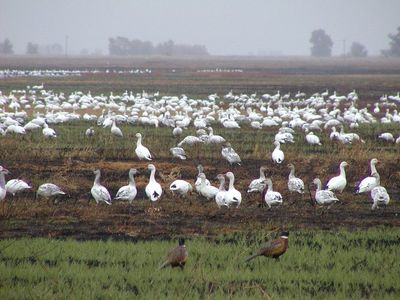
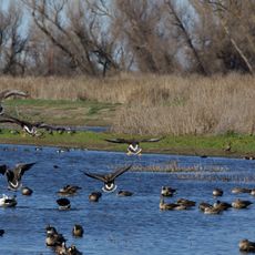
The Sutter National Wildlife Refuge is a protected area in Sutter County containing wetlands, riparian corridors, and grasslands spread across the Sacramento Valley. The site spans over 2,500 acres and links different habitats that support vast numbers of migratory birds.

The refuge was established in 1945 by the U.S. Fish and Wildlife Service as part of a broader conservation network in the Sacramento Valley. It grew from the need to protect bird populations and preserve wetlands for future generations.

The refuge serves as a learning space where visitors can observe how wetlands support wildlife and understand conservation efforts firsthand. People come here to connect with nature and see endangered species in their natural environment.

The site is open year-round for bird watching, photography, and hiking, with additional hunting activities during specific seasons. Visitors should bring weather-appropriate clothing and binoculars, and keep to marked paths to avoid disturbing wildlife.

The area floods annually through the Sutter Bypass, temporarily creating massive feeding grounds for migrating ducks and geese passing through the region. These inundations are unpredictable and turn parts of the refuge into shallow lakes for weeks at a time.

The community of curious travelers

AroundUs brings together thousands of curated places, local tips, and hidden gems, enriched daily by 60,000 contributors worldwide.

Start exploring
Location
Inception
1945
Part of
Sacramento National Wildlife Refuge Complex
GPS coordinates
39.08290,-121.75600
Latest update
December 11, 2025 18:04
Around this place
Woodland Opera House
United States of America

Woodland Opera House

45.1 km
Bok Kai Temple
United States of America

Bok Kai Temple

15.7 km
Englebright Lake
United States of America

Englebright Lake

45.4 km
Camp Far West Reservoir
United States of America

Camp Far West Reservoir

38.3 km
Delevan National Wildlife Refuge
United States of America

Delevan National Wildlife Refuge

39.5 km
Colusa National Wildlife Refuge
United States of America

Colusa National Wildlife Refuge

26.1 km
Ellis Lake
United States of America

Ellis Lake

16.3 km
Fremont Weir Wildlife Area
United States of America

Fremont Weir Wildlife Area

38.2 km
Englebright Dam
United States of America

Englebright Dam

45.5 km
Woodland Public Library
United States of America

Woodland Public Library

45 km
Hotel Woodland
United States of America

Hotel Woodland

45.2 km
Yolo County Courthouse
United States of America

Yolo County Courthouse

44.9 km
Sacramento Valley Museum
United States of America

Sacramento Valley Museum

35.9 km
Community Memorial Museum of Sutter County
United States of America

Community Memorial Museum of Sutter County

12.6 km
Downtown Woodland Historic District
United States of America

Downtown Woodland Historic District

45.1 km
Yolo Branch Library
United States of America

Yolo Branch Library

39.2 km
Live Oak Historic Commercial District
United States of America

Live Oak Historic Commercial District

22.9 km
Griffith Mansion
United States of America

Griffith Mansion

39.5 km
Yuba City Astronomical Observatory
United States of America

Yuba City Astronomical Observatory

11.1 km
Grand Island Shrine
United States of America

Grand Island Shrine

16 km
Porter Building
United States of America

Porter Building

45.1 km
Hart Building
United States of America

Hart Building

15.8 km
R. H. Beamer House
United States of America

R. H. Beamer House

44.4 km
Packard Library
United States of America

Packard Library

15.9 km
I.O.O.F. Building
United States of America

I.O.O.F. Building

45.1 km
Colusa County Courthouse
United States of America

Colusa County Courthouse

26.3 km
Marysville Historic Commercial District
United States of America

Marysville Historic Commercial District

15.7 km
Yuba County Library
United States of America

Yuba County Library

15.8 km
Show the full map
Reviews
Share your experience

No review yet

Discussions
Start a discussion...

No discussion yet

« Sutter National Wildlife Refuge - Wildlife refuge in Sutter County, United States » is provided by Around Us (aroundus.com). Images and texts are derived from Wikimedia project under a Creative Commons license. You are allowed to copy, distribute, and modify copies of this page, under the conditions set by the license, as long as this note is clearly visible.

Discover hidden gems everywhere you go!

From secret cafés to breathtaking viewpoints, skip the crowded tourist spots and find places that match your style. Our app makes it easy with voice search, smart filtering, route optimization, and insider tips from travelers worldwide. Download now for the complete mobile experience.

Around Us App Screenshot

A unique approach to discovering new places

Le Figaro

All the places worth exploring

France Info

A tailor-made excursion in just a few clicks

20 Minutes

Around Us
Travel Guide & Maps
Download

Send to your phone

QR Code
1

Open the camera app on your mobile.

2

Point at the QR code with your camera. A notification will appear.

3

Tap the notification to open the link.