Enable Location

We need your location to show you interesting places around you

Discover nearby places

Find interesting locations and hidden gems around you

Precise directions

Get accurate directions and distances to places

Your location is never shared with other users. It's only used when you tap the location button.

Colusa National Wildlife Refuge

Log in to your account

Start exploring — it's free

Trusted by 63,695 travelers worldwide

Continue with Google
Continue with Apple
or

We will send you a code to connect

By continuing, you accept our Terms and Conditions and our Privacy Policy

Check your inbox

We've sent a pincode in your inbox. Please enter the code below.

Colusa National Wildlife Refuge
Discussion Reviews 1 Photos
4.1k Popularity

Colusa National Wildlife Refuge, National wildlife refuge in Colusa County, United States

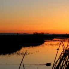
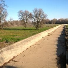
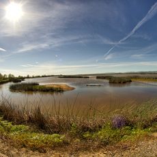
Colusa National Wildlife Refuge is a protected area with wetlands, grasslands, and riparian woods in the Sacramento Valley in northern California. The refuge offers maintained trails, observation platforms, and driving routes for visitors to explore.

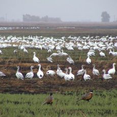
This refuge was established in 1945 as part of a network of protected lands in the Sacramento region. It was created to preserve important habitats for migrating bird species.

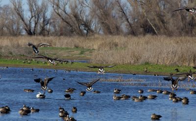
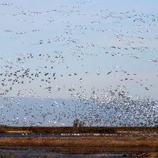
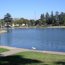
The refuge is a place where people come to watch waterfowl living in their natural habitats and understand how wetlands support wildlife. School groups and bird watchers regularly visit to experience these ecosystems firsthand.

The best time to visit is from September through March when most migrating birds are present. Visitors should arrive early in the morning to see the highest bird activity.

During winter months enormous flocks of waterfowl gather here as many species make a stopover during their migration. This makes the area one of the most important resting grounds for migrating birds across California.

The community of curious travelers

AroundUs brings together thousands of curated places, local tips, and hidden gems, enriched daily by 60,000 contributors worldwide.

Start exploring
Location
Inception
1945
Part of
Sacramento National Wildlife Refuge Complex
GPS coordinates
39.15740,-122.04300
Latest update
December 11, 2025 11:07
Around this place
Berryessa Snow Mountain National Monument
United States of America

Berryessa Snow Mountain National Monument

44.2 km
Sacramento National Wildlife Refuge Complex
United States of America

Sacramento National Wildlife Refuge Complex

32.8 km
Anderson Marsh State Historic Park
United States of America

Anderson Marsh State Historic Park

57.4 km
Bok Kai Temple
United States of America

Bok Kai Temple

39.5 km
Delevan National Wildlife Refuge
United States of America

Delevan National Wildlife Refuge

18.4 km
Sutter National Wildlife Refuge
United States of America

Sutter National Wildlife Refuge

26.1 km
Ellis Lake
United States of America

Ellis Lake

39.4 km
Fremont Weir Wildlife Area
United States of America

Fremont Weir Wildlife Area

56.7 km
Oroville Chinese Temple
United States of America

Oroville Chinese Temple

57.4 km
Blue Ridge Berryessa Natural Area
United States of America

Blue Ridge Berryessa Natural Area

54.9 km
Cache Creek Wilderness
United States of America

Cache Creek Wilderness

48.1 km
East Park Dam
United States of America

East Park Dam

46.4 km
Sacramento Valley Museum
United States of America

Sacramento Valley Museum

10.3 km
Zim Zim Falls
United States of America

Zim Zim Falls

48.3 km
Community Memorial Museum of Sutter County
United States of America

Community Memorial Museum of Sutter County

35.2 km
Yolo Branch Library
United States of America

Yolo Branch Library

51.4 km
Live Oak Historic Commercial District
United States of America

Live Oak Historic Commercial District

35.5 km
Griffith Mansion
United States of America

Griffith Mansion

51.8 km
Yuba City Astronomical Observatory
United States of America

Yuba City Astronomical Observatory

35.6 km
Grand Island Shrine
United States of America

Grand Island Shrine

10.3 km
Hart Building
United States of America

Hart Building

39.3 km
Packard Library
United States of America

Packard Library

39.4 km
Colusa County Courthouse
United States of America

Colusa County Courthouse

7 km
Marysville Historic Commercial District
United States of America

Marysville Historic Commercial District

39.3 km
Oroville Chinese Temple
United States of America

Oroville Chinese Temple

57.3 km
Bayliss Carnegie Library
United States of America

Bayliss Carnegie Library

47.4 km
Yuba County Library
United States of America

Yuba County Library

39.4 km
Sacramento National Wildlife Refuge
United States of America

Sacramento National Wildlife Refuge

30 km
Show the full map
Reviews
Share your experience

No review yet

Discussions
Start a discussion...

No discussion yet

« Colusa National Wildlife Refuge - National wildlife refuge in Colusa County, United States » is provided by Around Us (aroundus.com). Images and texts are derived from Wikimedia project under a Creative Commons license. You are allowed to copy, distribute, and modify copies of this page, under the conditions set by the license, as long as this note is clearly visible.

Discover hidden gems everywhere you go!

From secret cafés to breathtaking viewpoints, skip the crowded tourist spots and find places that match your style. Our app makes it easy with voice search, smart filtering, route optimization, and insider tips from travelers worldwide. Download now for the complete mobile experience.

Around Us App Screenshot

A unique approach to discovering new places

Le Figaro

All the places worth exploring

France Info

A tailor-made excursion in just a few clicks

20 Minutes

Around Us
Travel Guide & Maps
Download

Send to your phone

QR Code
1

Open the camera app on your mobile.

2

Point at the QR code with your camera. A notification will appear.

3

Tap the notification to open the link.